

Carthay Center
You are here
Carthay Circle
1922–1944, Curlett and Beelman, planners; Cook and Hall, landscape architects. Roughly bounded by La Cienega Blvd., Wilshire Blvd., Fairfax Ave., and Pico Blvd.
-
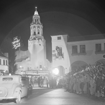 1937 premiere of "The Life of Emile Zola" (Courtesy of the Los Angeles Times Photographic Archive, Department of Special Collections, Charles E. Young Research Library, UCLA)
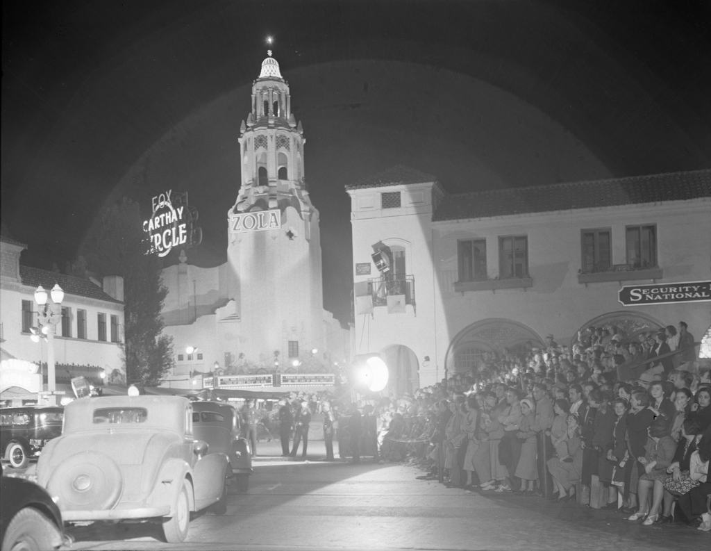
Like other early-twentieth-century planned communities in Southern California that were designed to address population growth, Carthay Circle featured innovative approaches to planning such as the provision of public facilities, a focus on recreation, and denser housing patterns. In 1922, J. Harvey McCarthy, who had previously planned and developed the Fremont Park Place Area, set out to create a community and commercial center that rivaled the recently developed Miracle Mile by A.W. Ross, located east of McCarthy’s proposed development. Carthay Center, as it was originally called, featured a central shopping center surrounded by Spanish Colonial Revival houses. Architects Aleck Curlett and Claud Beelman created a master plan for the 136-acre site in 1924, in collaboration with landscape architects David Cook and George Hall. Sandwiched by existing development (Beverly Hills is to the west) and diagonally bisected by San Vicente Boulevard, the overall plan of Carthay Circle constituted a collision of different grids adhering to the bounding boulevards. Carthay Circle was the first subdivision in Los Angeles to bury its utilities, removing unsightly telephone and electric wires.
Although most of the area was zoned for one-story, single-family residences, the plan included land for a theater, shopping center, public elementary school, and a small church. The first major construction was the centrally located Carthay Circle Theatre (from which the development ultimately took its name), completed in 1926. Designed by A. Dwight Gibbs in the Spanish Baroque style, the building included arches at the base and a lighted tower, complete with a large neon sign. Its auditorium was circular, with an innovative lighting system designed by Claude D. Seaman. The theater became known for its film premieres, including Walt Disney’s first animated feature-length film, Snow White and the Seven Dwarfs (1937), as well as Gone with the Wind (1939), bringing fame to the theater and surrounding development. The theater was demolished in 1969; on its former site are two office buildings separated by a small park.
Alongside the theater, McCarthy built an elementary school, designed by Horatio W. Bishop and Carleton M. Winslow in 1926. In order to spur development and the sale of lots, McCarthy formed the Carthay Center Holding Corporation to engage in the development of community improvements including roads and sidewalks, streetlights, and underground utilities. Additionally, Carthay Circle is unique in its creation of six pedestrian pathways that cut through the large blocks, allowing residents to traverse the neighborhood away from street traffic.
The strict provisions in the deeds, stipulating that owners must be white and that houses must not have flat roofs, were lauded by architects and planners at the time. A jury including Sumner Hunt, John Prince, Myron Hunt, Emil T. Mische, and president of the City Planning Commission of Los Angeles, James Langston, judged Carthay Circle to be one of the best developments in Southern California, stating that “the areas are excellently arranged so the protection to the ultimate resident-owners against depreciating and antagonistic occupation, by a different standard than initially started, is well controlled.”
McCarthy proceeded to hire Bishop, a prominent Boston architect, to coordinate a number of architects in the design of the individual residences. Many of the houses were designed by Irving J. Gill while he was under the employ of Bishop. Although the Spanish Colonial Revival style dominated, as was the case in other neighborhoods like Leimert Park, other designs were also employed, including English, Tudor, French Norman, and Monterey styles.
In 1937, Gregory Ain was tasked with squeezing four town house units onto a narrow and deep lot in Carthay Circle just south of San Vicente Boulevard. The Dunsmuir Flats were placed end-to-end and staggered to allow each to receive abundant natural light. Private patios connected to a shared garden landscape on the south side that extended from the street to the back of the lot. The flats kicked off a ten-year series of designs for low-cost housing.
In 1998, the community was officially changed to Carthay Circle and adopted as a Historic Preservation Overlay Zone. As a result, most of the original development remains intact.
References
“Carthay Circle History.” Carthay Circle Neighborhood Association. Accessed July 19, 2017. http://www.carthaycircle.org/.
Gebhard, David, and Robert Winter. An Architectural Guidebook to Los Angeles. Salt Lake City, UT: Gibbs Smith, 2003.
Hise, Greg. Magnetic Los Angeles: Planning the Twentieth-Century Metropolis. Baltimore: Johns Hopkins University Press, 1997.
Olsberg, Nicholas. “Open World: California Architects and the Modern Home.” In Living in a Modern Way: California Design 1930-1965, edited by Wendy Kaplan. Cambridge: MIT Press, 2011.
Wallach, Ruth. Los Angeles Residential Architecture: Modernism Meets Eclecticism. Charleston, SC: History Press, 2015.
Wallach, Ruth. Miracle Mile in Los Angeles: History and Architecture. Charleston, SC: History Press, 2013.
Writing Credits
Coordinator:
Emily Bills
If SAH Archipedia has been useful to you, please consider supporting it.
SAH Archipedia tells the story of the United States through its buildings, landscapes, and cities. This freely available resource empowers the public with authoritative knowledge that deepens their understanding and appreciation of the built environment. But the Society of Architectural Historians, which created SAH Archipedia with University of Virginia Press, needs your support to maintain the high-caliber research, writing, photography, cartography, editing, design, and programming that make SAH Archipedia a trusted online resource available to all who value the history of place, heritage tourism, and learning.