

Pasadena Freeway
You are here
Arroyo Seco Parkway


1938–1940; 1953 extension; 2010 improvements. Between Los Angeles and Pasadena.
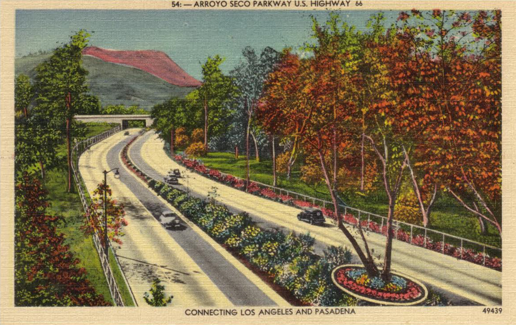
The Arroyo Seco Parkway is known as the first freeway in the western United States. It is an eight-mile-long connection between Los Angeles and Pasadena, running along a mostly dry riverbed (which gives the parkway its name). It crosses the neighborhoods of Chinatown, Elysian Park, Highland Park, and South Pasadena, and grants access to Dodger Stadium. The majority of the road system, with its main tunnels and bridges, opened in 1940.
The City of Pasadena was incorporated in 1883 and rapidly developed into the preferred winter residence for wealthy industrialists from the East Coast, especially once the first transcontinental railroad opened. It spurred the development of new neighborhoods and a business district. Pasadena also became increasingly popular as a residential alternative for Los Angeles citizens, which made road and transit connections between the cities necessary.
Before the construction of the Arroyo Secco Parkway, several bridges were already built and are still in use today: the York Boulevard Bridge was erected in 1912; the Avenue 26 Bridge in 1925; and the Avenue 60 Bridge in 1926. The area of the Arroyo Seco was also the location of a planned commuter cycleway in 1897, which was only partially constructed as an elevated, wooden bikeway that opened in 1900. In the first decades of the twentieth century, several plans were formulated to create a new connection along the riverbed for the increasing amount of car users. Part of the first steps of development in the 1930s was the construction of four Art Deco tunnels at the western end of the project in Elysian Park.
The official construction started on March 22, 1938 under the leadership of district chief engineer Spencer V. Cortelyou and design engineer A. D. Griffin. It was originally planned as a parkway, in the tradition of its east coast predecessors, which were designed as a pleasurable drive through beautiful scenery. It was ultimately designed according to the principles of a freeway, not a parkway, as it had to accommodate a large amount of traffic. It is a prime example of the transition from recreational parkways to purely functional freeways, representing an important stage in the development of American transportation engineering. The Arroyo Seco retained some features of the parkway, specifically the use of large amounts of native plants along its path—approximately ten thousand plants comprising a total of forty-seven species. White wooden railings flanked the on- and off-ramps and Arts and Crafts–style composite rubble masonry walls were used in several parts of the parkway.
The freeway was originally designed with two 12-foot lanes and one 10-foot shoulder in each direction, but by 1939 the shoulders were transformed into additional travel lanes. By the 1940s, many new freeways were constructed around Los Angeles, connecting the city with the surrounding areas. The center of the newly developed freeway system was a four-level interchange just north of downtown Los Angeles; it was the first stacked interchange in the world. It was completed in 1949, but the Arroyo Seco Freeway extension was not connected until 1953.
The freeway was designed for a top speed of 45 miles per hour, which was adequate at the time of construction, but it was increased in the latter half of the century to 55 miles. The resulting entrances and exits have no acceleration or deceleration lane, which makes it difficult to navigate with today’s cars; the recommended speed on these on and off ramps is 5 miles per hour.
In 2010, the median, which was originally a 4-foot planter filled with shrubs and replaced in 1962 with steel guardrails, was upgraded with new concrete barriers, in order to provide more safety. Caltrans also installed new lighting and decorative low walls along the shoulders. At that time the name was also changed back from Pasadena Freeway to its original Arroyo Seco Parkway.
References
Fisher, Jay. “Shabby Road: The Ills and Charms of California’s First Freeway.” New York Times, August 15, 2008.
Gruen, J. Philip, and Portia Lee, “Arroyo Seco Parkway,” Los Angeles County, California. Historic American Engineering Record, 1999. Prints and Photographs Division, Library of Congress (HAER No. CA-265).
Pool, Bob. “Pasadena Freeway getting a new look and a new name.” Los Angeles Times, June 25, 1010.
Writing Credits
Coordinator:
Emily Bills
If SAH Archipedia has been useful to you, please consider supporting it.
SAH Archipedia tells the story of the United States through its buildings, landscapes, and cities. This freely available resource empowers the public with authoritative knowledge that deepens their understanding and appreciation of the built environment. But the Society of Architectural Historians, which created SAH Archipedia with University of Virginia Press, needs your support to maintain the high-caliber research, writing, photography, cartography, editing, design, and programming that make SAH Archipedia a trusted online resource available to all who value the history of place, heritage tourism, and learning.