


Hargreaves and Associates, in collaboration with the environmental artists Peter Richards and Michael Oppenheimer, created Byxbee Park in Palo Alto in 1990–1991 to remediate a former landfill and to accommodate the recreational interests of local joggers, walkers, and birdwatchers. The park covers approximately 30 acres of a landfill that had only been closed a few years earlier and is located adjacent to a tidal creek, a sewage treatment plant, and an active landfill on the South Shore of San Francisco Bay. It lies approximately 2.5 miles east of Stanford University’s campus in Palo Alto. It is surrounded by remnants of marshland crossed by high-voltage transmission lines and lies underneath the flight path of small planes that land and take off at Palo Alto’s municipal airport to the northwest of the park. The park is accessible from Embarcadero Road and from the South Bay trail system.
To turn the landfill into publicly accessible parkland, it was capped with one foot of impenetrable clay and covered with two feet of earth. To protect the cap and prevent toxic substances from leaching into the bay, the designers created a park without trees and artificial irrigation. They adopted a sculptural approach that was generated by the site’s environmental conditions, including the wind and shallow soil, as well as its land-use history and the aerial view. Ground modeling and all sculptural interventions, such as the thirty-foot-high installation Wind Wave and the field of regularly spaced wooden telephone poles, provide visual and spatial interesting and captivating phenomenological experiences on the ground.
Wind Wave consists of two vertical poles with several vertical ropes hanging from a single rope suspended between the poles. Visible from afar, the art work functions as a landmark as well as a large wind chime that registers the wind through the movement of the hanging ropes and the sounds created in the process.
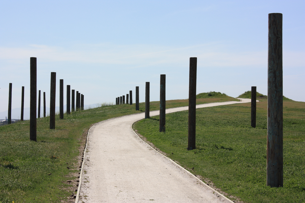
The grid of 72 truncated telephone poles visually connects the site to the larger landscape in which utility poles cross the Bay and appear along the horizon. Built on sloping terrain so that the top of all 72 poles reached the same height and create an even datum, the artists conceived of the poles as markers of soil decomposition and settlement over time.
Teardrop-shaped hillocks along the site’s ridgeline recall the middens of the Ohlone people, natives of the region. They were designed to change wind patterns and catch seeds, thus enabling the establishment of spontaneous vegetation on site.
Other interventions were designed not only for park visitors but also for pilots on the approach path to Palo Alto airport. To enhance this aerial perspective, a row of standard, precast concrete highway barriers is positioned on one of the slopes below the flight path to form an aeronautical symbol typically found on the blast pads at the beginning of airport runways. On the ground, the concrete barriers slow down runoff, diminishing the amount of polluted water running into the bay and creating humid micro biotopes. Other environmental processes made visible on the site include the continual flame that burns the methane gas produced by the disintegration of the fill underground and the underlying bed of white gravel. The keyhole shape of the gravel bed is only perceptible from the air. Its orientation takes into account the main direction of planes approaching the nearby runways to land. Even if pilots cannot easily comprehend the visual metaphor suggesting they are peering through a keyhole into the underground of decomposing trash, the keyhole, like the concrete barriers, provides pilots with a distinct landmark for orientation. Overall, the park design attempts to keep the memory of the site’s previous use as a landfill alive while directing its development towards new configurations.
After two decades of subsidence on the site due to decomposition and consolidation of the buried refuse and the compaction and dewatering of the underlying bay muds, the City of Palo Alto undertook necessary repairs and design changes in 2012–2013. Most of the hillocks were leveled, the oyster-shell paths and keyhole buried, many weirs filled, and a hedgerow was removed. Nevertheless, the park remains a precedent and model for other disturbed sites even as it continues to be modified. Today, the park forms part of the Palo Alto Baylands Nature Preserve.
References
Lee, Lydia. “The Dismemberment of Byxbee Park.” Landscape Architecture Magazine, October 29, 2013.
Beardsley, John. “Entropy and the New Landscapes.” In Process Architecture 128: Hargreaves, Landscape Works. Edited by Steve Hanson, 14-25. Tokyo: Process Architecture Co., 1996.
Engler, Mira. Designing America’s Waste Landscapes. Baltimore: Johns Hopkins University Press, 2004.
Rainey, Reuben M. “Environmental Ethics and Park Design: A Case Study of Byxbee Park.” Journal of Garden History 14, no. 1 (1994): 171-178.