

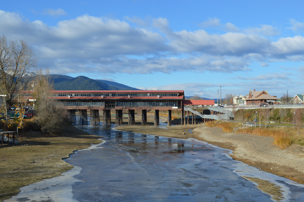
Cedar Street Bridge
You are here
Cedar Street Bridge Public Market


c. 1893–c. 1926, L.D. Farmin and A.P Gillies; 1983–2005 reconstructed, Scott Glickenhaus and Jonathan Stoumen. 334 N. 1st Ave. and Cedar St.


The enclosed public market that now occupies the Cedar Street Bridge has its origins in the first crude footbridge built across Sand Creek circa 1893. For nearly a century, one bridge after another has connected Sandpoint’s commercial core with its economic lifeline, the Northern Pacific Railroad, each one paralleling Sandpoint’s evolution from squatter settlement, to railroad and mill town, to resort town.
The commanding geography that gave Sandpoint its name created challenges and opportunities for early settlers. The Northern Pacific Railroad laid tracks for a transcontinental route across a flood-prone, narrow spit of land separating Sand Creek and Lake Pende Oreille with no intention of establishing a town in such a tenuous foothold. In 1883, squatters nonetheless set up a small settlement along each side of the railroad tracks, though the geographic constraints, spring flooding, and a reputation for rowdiness inhibited permanent development. Eventually events conspired to relocate the fledgling town across Sand Creek: in 1892, the Great Northern Railway completed a competing transcontinental route one mile to the west across Sand Creek; in 1894, a cataclysmic spring flood forced the Northern Pacific to berm up its tracks by ten feet, thus dividing the lower-lying squatter settlement in half. L.D. Farmin, a Great Northern employee and homesteader, envisioned a permanent town on the west (opposite) side of Sand Creek where he and his wife, Ella, owned 160 acres. Their land, strategically located between the two transcontinental lines, offered higher ground and ample room for growth. In 1898, Farmin platted the townsite’s first phase and successfully lured businesses and settlers from the creek’s east side. The relocated town needed foot and wagon bridges across Sand Creek to maintain a vital connection to the Northern Pacific depot and freight lines.
The first Cedar Street Bridge was a low-lying wooden pedestrian bridge that was inadequate for spring floods. Once migration across Sand Creek became inevitable, Kootenai County built a permanent wagon bridge, but it too was prone to flood damage. When the financially strapped county turned to the private sector for a replacement, local businessman and politician Ignatz Weil offered to fund the construction in order to site the new bridge closer to his own commercial enterprises. Weil’s new bridge featured a small brothel and saloon at mid-span, setting a community precedent for erecting buildings on Sand Creek crossings. Farmin advocated for a bridge to be rebuilt on the former Cedar Street Bridge site because it afforded direct access between the Northern Pacific depot and the heart of Sandpoint’s new commercial district. Unable to secure public funding, Farmin fronted the $1,590 required to construct a high-lying replacement bridge to span 400 feet across Sand Creek. In 1903, Farmin engaged A.P. Gillies to design and construct the new Cedar Street Bridge according to specifications for a 16-foot-wide wagon lane alongside a 6-foot-wide pedestrian walkway.
As transportation systems evolved, the Cedar Street Bridge was reconstructed several times to accommodate changing infrastructure needs. In the late 1920s, the bridge was rebuilt with heavy timbers to handle automobile and pedestrian crossings and it became a popular destination for community recreation. Over time, supporting wooden pilings and timber structural elements deteriorated and in 1971 the city condemned the bridge as a public hazard. By then, the nearby Bridge Street Bridge had also fallen into disrepair. Lacking funds to restore both bridges, the Sandpoint city government deemed the Bridge Street crossing more worthy of public investment. This decision was motivated by a shift in the economic priorities toward investment in tourism. Bridge Street served as a direct connection between the tourist destinations downtown and the Sandpoint City Beach. In addition, there was less of a need for a crossing at Cedar Street since passenger rail service at the Northern Pacific depot had declined.
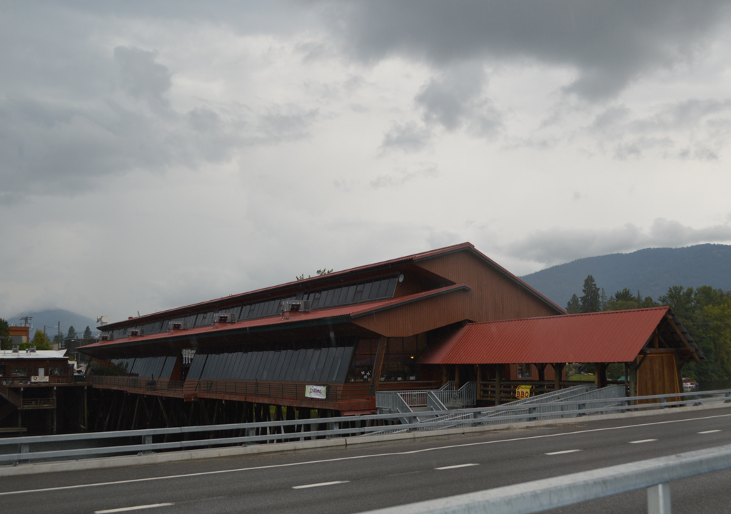
But the Cedar Street Bridge was still considered a local landmark, though it remained in a state of preservation by neglect for a decade until developer Scott Glickenhaus recognized its potential for adaptive use as a tourist destination. While the city contemplated the bridge’s demolition, Glickenhaus planned for its restoration into a marketplace modeled after Ponte Vecchio in Florence, Italy. Glickenhaus leased the bridge from the city in 1982 for one dollar annually and posted a $17,500 cash performance bond to ensure that the bridge would be properly reconstructed. While the transaction was not without legal controversy, Glickenhaus’s vision to develop the bridge as a one of the few overwater marketplaces in the world prevailed. Glickenhaus commissioned California architect Jonathan Stoumen to design a retail building on top of a reconstructed bridge within the public right of way. To maintain a direct connection from the depot to downtown for Amtrak passengers, the facility included an integrated exterior walkway along its southern facade.
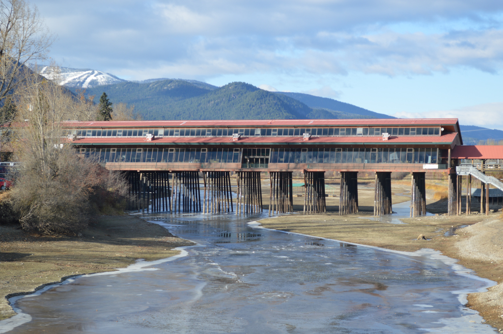
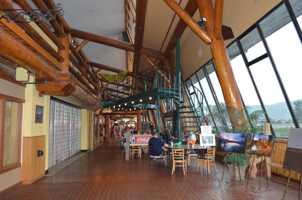
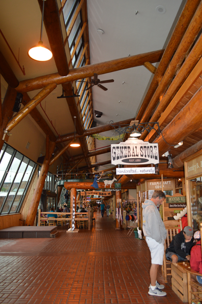
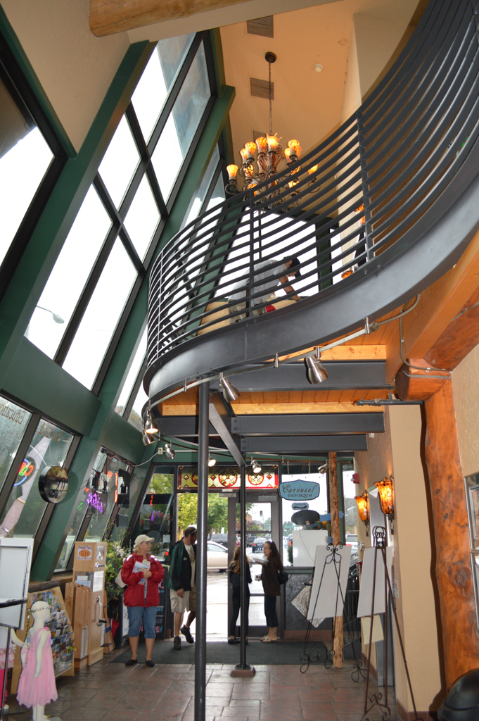
Stoumen’s retail building derives aesthetic inspiration from New England covered bridges and the vernacular of northwest lodges and programmatic inspiration from the medieval Ponte Vecchio and contemporary festival marketplaces. The building’s exposed structural system consists of two-foot-diameter old growth tamarack logs, which were harvested from a grove of standing dead timber. Each log was hand peeled and notched in Hamilton, Montana, numbered for onsite assembly, and hoisted into place using cranes to form the marketplace’s 35-foot exposed ceiling. The foundation for the new bridge is supported by pressure-treated wood pilings that were driven 45 feet into the creek bed to insure protection against flooding. The marketplace building also exemplifies late-twentieth-century attitudes toward green design. Because the bridge crosses Sand Creek along an east-west axis, Stoumen was able to optimize integrated passive solar features: glazing on the south side is angled at 19 degrees to maximize the long-angled winter sun; the building’s concrete flooring acts as thermal mass in the winter; and during summer months the building is cooled using a combination of cross ventilation, stack ventilation, and cooler air that circulates from underneath the bridge.
In 1982, an enclosed marketplace was constructed on the palimpsest of community bridges that had spanned Sand Creek for nearly one hundred years. Contemporary Sandpoint’s citizenry and visitors celebrate the historic spanning of Sand Creek via an iconic marketplace bridge and community center.
At the grand opening in May 1983, the marketplace bridge was fully occupied by an assortment of local artisans, vendors, and small retail shops. The building’s novelty and festive atmosphere became a prime tourist attraction. Coldwater Creek, now a national company, began as a small retail operation on the bridge before expanding in 1995 into the entire building and remodeling the interior. In 2005, Coldwater Creek moved its operations to a historic building across the street, leaving the bridge facility vacant. Glickenhaus sold the Cedar Street Bridge building to local realtors who invested $1.25 million to restore it as a public marketplace and tourist destination. This occurred just as a four-lane bypass paralleling the railroad tracks was completed. The 1916 depot, the last in a sequence built by the Northern Pacific Railroad on the east side of Sand Creek, marks the site of the original squatter settlement. Though the depot’s historic connection to downtown via a crossing at Cedar Street has been permanently severed, the Cedar Street Bridge Public Market serves as an icon for community memory and place-making.
References
“Cedar Street Bridge: A Span across Sandpoint's History.” http://cedarstreetbridge.com.
Glickenhaus, Scott. Interview by Alena N. Horowitz. Sandpoint, ID, October 22, 2014.
Glickenhaus, Scott. “Project book for Cedar Street Bridge, 1980-1982.” Personal Collection.
Gunter, David. “The Bridge is back: Old world charm, small town appeal.” BonnerBIZ Bonner County’s Business Source, January 2008.
Gunter, David. “Cedar Street Public Market returns to its retail roots.” BonnerBIZ Bonner County’s Business Source, January 2008.
Horowitz, Alena N. “The Cedar Street Bridge: Connecting the people of Sandpoint throughout history.” Seminar Paper, University of Idaho, November 2014.
McClure, W. “Sustainable Town-making and Transformations in the Intermountain West” Unpublished manuscript, last modified June 3, 2015. Microsoft Word file.
McClure, W. “Railroad Towns.” Encyclopedia of Community: Shared Places, Shared Meanings, from the Village to Virtual World. Vol. 3. Berkshire Publishing LTD, 2003.
McClure, Wendy. “Sustaining inherited morphology in the adaptation of railroad era towns for recreation economies: A case of Sandpoint, Idaho.” Paper presented at the Annual National Conference of the Association of Collegiate Schools of Planning, Salt Lake City, Utah, October 13-16, 2011.
Pietsch, Gary L. “Bridges Over Sand Creek.” [Photographs] Bonner County History Museum. Accessed October 22, 2014. .
Sandpoint Historic Preservation Commission. “History of the City of Sandpoint.” The City of Sandpoint. http://www.cityofsandpoint.com/.
Snedden, Evelyn. “The History of Sandpoint.” In Beautiful Bonner: The History of Bonner County, Idaho,edited by Marilyn Cork .Dallas, TX: Curtis Media Corporation, 1991.
Stoumen, Jonathan. “The Cedar St. Bridge.” Jonathan Stoumen Architect. Accessed October 22, 2014. http://www.stoumen.com/stoumen.com/Cedar_St.html.
Writing Credits
Coordinator:
Anne L. Marshall
Wendy R. McClure
Phillip G. Mead
D. Nels Reese
If SAH Archipedia has been useful to you, please consider supporting it.
SAH Archipedia tells the story of the United States through its buildings, landscapes, and cities. This freely available resource empowers the public with authoritative knowledge that deepens their understanding and appreciation of the built environment. But the Society of Architectural Historians, which created SAH Archipedia with University of Virginia Press, needs your support to maintain the high-caliber research, writing, photography, cartography, editing, design, and programming that make SAH Archipedia a trusted online resource available to all who value the history of place, heritage tourism, and learning.