

Nez Perce National Historical Park
You are here
Fort Lapwai Officers’ Quarters


1879–1883, U. S. Army. C St. and Phinney Dr.
The officers’ quarters is one of only three buildings remaining from Fort Lapwai, a fort established in 1862 to protect Nez Perce people from miners trespassing on the Nez Perce Reservation after gold was discovered in 1860 along a tributary of the Clearwater River.
For thousands of years, Nez Perce people, who call themselves Nimiipuu, migrated seasonally following food sources, but returned each year to established villages along the Clearwater, Lower Snake, and Lower Salmon rivers and their tributaries. By the mid-1800s, however, as increasing numbers of European Americans came into Nimiipuu lands and competed for resources, conflict erupted. Consequently, Nez Perce people entered into a treaty in 1855 that established the Nez Perce Reservation on approximately 7.5 million acres spread across portions of what are today the states of Idaho, Washington, and Oregon. Significantly, the treaty required the Nez Perces to cede 5 million acres of their traditional homeland to the U.S. government, effectively opening it up to white settlement. Not only did the US government fail to live up to the agreed terms of the treaty, but after gold was discovered on the reservation, white miners ignored treaty terms and swarmed the reservation in 1861. The following year, in response to the alarm sounded by the Indian agent, a company of volunteers led by Major J. S. Rinearson established Camp Lapwai, later Fort Lapwai, along Lapwai Creek six miles south of the Indian Agency.
The U.S. government also responded by reducing the size of the reservation. In May 1863 the Department of the Interior held a council at Lapwai council grounds that led to the Treaty of 1863, the so-called “Thief Treaty,” whose purpose was to reduce the size of the reservation to exclude mining areas and the town of Lewiston. The treaty reduced the original reservation by ninety percent to 750,000 acres, all in Idaho Territory. Some Nez Perce people were unwilling to cede additional land and refused to sign the treaty.
Among them was a band of non-treaty Nez Perces living in the Wallowa Valley of Oregon who were unwilling to leave their homeland and move to the smaller reservation in Idaho Territory. At an 1876 meeting at the Lapwai agency church, General Oliver O. Howard urged non-treaty people to move onto the reservation, but their leader, Chief Joseph, refused to give up his homeland. In May of the following year, Howard and Indian Agent John Monteith met Joseph and non-treaty Nez Perces in council on the parade ground at Fort Lapwai and issued an ultimatum: move to the reservation within thirty days or face consequences. A month later, in the event known as the Nez Perce War, Chief Joseph led his band on a 1,170-mile retreat before surrendering to the U.S. Army forty miles south of the Canadian border.
At the outset of the war, the fort became a gathering place for Nez Perce and European-American people concerned for their safety as conflict erupted. Subsequently, Fort Lapwai became the regimental headquarters for the duration of the war. Prisoners of war were held in the fort’s guardhouse and wounded were cared for in its hospital. After Chief Joseph surrendered in October 1877, Fort Lapwai’s strategic importance decreased and the fort was decommissioned in 1884.
Fort Lapwai consisted of a series of individual buildings lining the perimeter of a rectangular parade ground, all surrounded by a fence. Volunteer troops and citizen craftsmen built most of the fort’s structures between 1862 and1864. Since little timber grew on or adjacent to the fort, it was transported to the site by mule and wagon from a forest a few miles to the south and cut into lumber at a sawmill acquired in 1862. By the beginning of 1863, company quarters were finished and officers’ quarters nearly enclosed. The two barracks, one for infantry and another for cavalry lined the east side of the parade ground facing two duplex officers’ quarters along the west side. The guard house was along the north end. Other buildings completed in 1863 included the bakery, quartermaster storehouse, commissary storehouse, hospital, adjutant’s office, laundresses’ quarters, and cavalry and quartermaster stables.
By the 1870s, although the original buildings had deteriorated considerably, requests for repairs were denied repeatedly. Also denied were requests to build additional quarters for officers and their families. Not only did the four sets of quarters in the two existing duplexes contain less space than army regulations stipulated, they were often occupied by more than four officers. In 1878, the overcrowding was extreme, as eighteen commissioned officers, including four families, occupied fifteen rooms, six of which were too small and low to meet army standards. To remedy this situation, permission was finally granted to construct a third, duplex officers’ quarters.
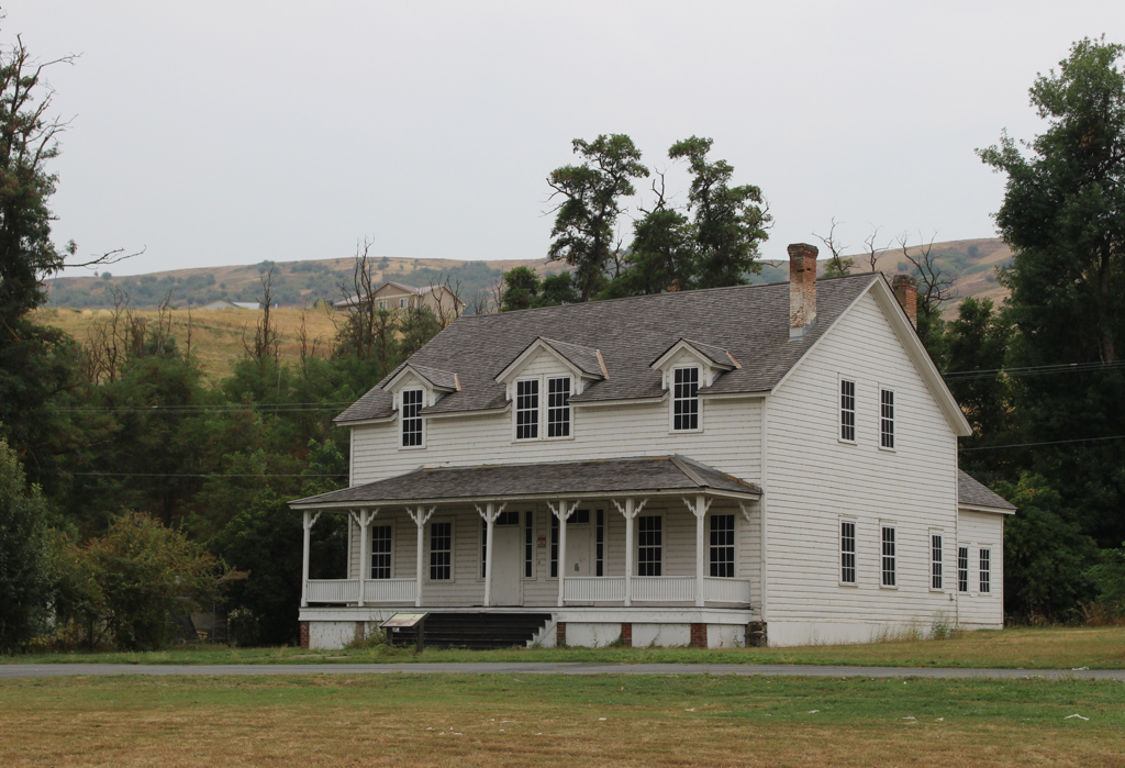
The new building was located at the southwest corner of the parade ground, aligned with the other two duplex officers’ quarters. The back portion of the building, a kitchen and woodshed on each side, was built in 1879, but construction on the front rooms of the duplex did not begin until 1883. The building was occupied by January 1, 1884 but it was only occupied for seven months as the fort was abandoned in August. This is the only surviving building of officers’ row.
The officers’ quarters is a symmetrical, two-story, wood-frame building designed to house two families. A hip-roofed veranda spans the east-facing clapboard facade; the jigsawed knee bracing from the wood posts supporting the veranda roof is the only ornament on the otherwise serviceable exterior. Six-over-six double-hung windows admit light through the front and side walls. Dormer windows hint that spaces on the second floor are quite low. From the veranda, adjacent twin entrance doors lead into the two residences. Each has a hall, parlor, dining room, kitchen, and woodshed on the first floor and a straight stair leading to the second floor, which contains three low-ceilinged bedrooms and four closets tucked under the eaves in each residence. Although drawings show a fireplace in each parlor and dining room and a shared chimney above the kitchens, the chimney from the southern parlor has been removed.
After it was decommissioned in 1884, Fort Lapwai was transferred to the Office of Indian Affairs, which administered a boarding school on the former fort grounds. The officers’ quarters was converted to a civilian residential duplex in the early 1900s to house teachers at the school. After the Nez Perce National Historical Park was established in 1965, the park entered into a cooperative agreement to provide technical assistance to maintain the officers’ quarters and install and maintain an interpretive sign. Although the building is unoccupied, its exterior presence facing Fort Lapwai’s parade ground allows visitors to get some sense of the former military presence on the land. Yet the interior of the officers’ quarters has potential for use too, and it is one of several key buildings that the Nez Perce Tribe intends to repurpose once funding becomes available.
References
Burroughs, Daniel F., Alfred C. Kuehl, John A Hussey, and Erwin N. Thompson. Feasibility Report: Nez Perce Country National Historic Sites, Idaho. National Park Service, U.S. Department of the Interior, Western Regional Office, 1964.
Thompson, Erwin N. Fort Lapwai, Nez Perce National Historical Park[historic resource study]. Denver Service Center, Historic Preservation Team, National Park Service, U.S. Department of the Interior, Denver, CO, 1973.
Writing Credits
Coordinator:
Anne L. Marshall
Wendy R. McClure
Phillip G. Mead
D. Nels Reese
If SAH Archipedia has been useful to you, please consider supporting it.
SAH Archipedia tells the story of the United States through its buildings, landscapes, and cities. This freely available resource empowers the public with authoritative knowledge that deepens their understanding and appreciation of the built environment. But the Society of Architectural Historians, which created SAH Archipedia with University of Virginia Press, needs your support to maintain the high-caliber research, writing, photography, cartography, editing, design, and programming that make SAH Archipedia a trusted online resource available to all who value the history of place, heritage tourism, and learning.