


The Spalding Visitor Center of the Nez Perce National Historical Park was built to serve as the headquarters for a national park that is unusual in several ways. Unlike parks that focus on protecting and interpreting natural phenomena or specific historic episodes, the aim of the Nez Perce National Historical Park is to preserve and protect resources documenting history of the Nez Perce people and their relationship to the natural world. The park is not a single, contiguous, federally owned area but instead comprises multiple public and privately owned sites. In this park architectural design is used to represent Nez Perce culture, to accommodate activities that promote understanding between Nez Perce people and others, and to link 38 isolated sites spread across Idaho, Oregon, Washington, and Montana.
Nez Perce culture is a living culture that has adapted and changed over the years in response to interaction with other people and changing resources and opportunities. Today, although many Nez Perce people live on or near the Idaho reservation, some live in urban environments or on other reservations. Ancestors of Nez Perce people, who call themselves Nimiipuu, have lived along the Clearwater, lower Snake, and lower Salmon rivers and their tributaries for more than 14,000 years. For at least 5,000 years, they have lived in villages, first in semi-subterranean pit houses, and later in long lodges and tipis. When Lewis and Clark entered Nimiipuu territory in 1805, more than a hundred permanent villages housed a total population of approximately 12,000. Through interaction with European Americans, Nimiipuu lives changed dramatically. It is the long continuum of Nimiipuu history that the Nez Perce National Historical Park seeks to represent.
The park was created through the efforts of two different groups. In the early 1920s, white residents of the area, led by the Daughters of the American Revolution (DAR), sought to commemorate the location of the 1838 mission established by Presbyterians Henry and Eliza Spalding. The DAR lobbied the governor to create Spalding State Park in 1936, and formed a Spalding Museum Foundation in 1953 to lobby for a museum and later for a national park. The Nez Perce Tribe, whose dominant concern in 1960 was underemployment, sought to stimulate economic development through cultural tourism. In 1961 the Nez Perce Tribal Executive Committee (NPTEC) established the Nez Perce Tribal Development Committee whose tourism subcommittee joined forces with the DAR, government agencies, and legislators to develop a proposal to create a national park. On May 15, 1965, Public Law 89-19 established Nez Perce National Historical Park as a unit of the national park system and authorized $1.8 million for construction, restoration work, and other improvements for the entire park.
When the park’s first superintendent, Robert L. Burns, arrived three months later, he established the park’s temporary headquarters in the historic Watson’s Store, which the Tribe had purchased with the intent of incorporating it into the new national park. The next superintendent, Jack Williams, moved into the renovated Blue Lantern Motel, which served as a temporary administration building, ranger quarters, and visitor center. Although the park’s masterplan had identified a site for a permanent visitor center in 1968, it would be more than a dozen years before it was finally built.
Funding was delayed repeatedly beginning in the early 1970s when President Nixon removed construction funds from National Park Service (NPS) budgets. By 1973, the limited funding that was available was directed towards sites associated with the American Bicentennial. Only in 1976 was Superintendent Robert L. Morris, with help from his regional director, able to persuade Congress to raise development spending for the park to $4.1 million, enough to build the visitor center. NPS broke ground in the fall of 1979; park staff moved into the building in February 1981; and the Spalding Visitor Center opened to the public in June 1983.
Well in advance of funding, representatives from the Nez Perce Tribe and NPS began discussing the visitor center’s design. The design team from NPS’s Denver Service Center included Richard J. Kusek, architect; Geoffrey Swan, landscape architect; and James Buckel, civil engineer. They collaborated with members of NPTEC, including Richard A. Halfmoon, Allen Moody, and Wilfred Scott to develop the visitor center design. As the headquarters for the entire Nez Perce National Historical Park, the building needed to accommodate multiple purposes including administration, information, interpretation, maintenance, and protection of the park. It also needed to represent the Nez Perce people and their culture. Designers suggested that a bold exterior form would communicate the Nez Perce identity of the building. At first they suggested a tall, conical building in the form of a tipi. Nez Perce leaders rejected the design because they felt that, while the building did resemble a common historic housing type still occasionally in use, it did not represent the Nez Perce as a living culture and did not reflect their relationship to the land. Designers then proposed a design generated from triangular geometry found in Nez Perce beadwork and similar in form to an arrowhead.
In a series of documents written in 1973, designers articulated their guiding concepts and principles. They argued that site conditions, such as the two highways bounding the site and the V-shaped canyon sculpted by nature, suggested the use of earthshaping or earthen berms as an important aspect of the design. Similarly, because the ancestral Nez Perce dwelling was the pit house, a design “of-the-earth” seemed more appropriate than a building placed on the land. Not only did designers aim for a building that represented what they saw as the past, present, and future of the Nez Perce culture, they also optimistically envisioned a utopian architecture that might “provoke impulses, raise questions, and force a dialogue” as an alternative to confrontation between Nez Perce people and European Americans. The designers advocated for a building that was focused on accommodation rather than confrontation and that was in harmony with Mother Nature. They believed the visitor center should incorporate multi-sensory participatory activities in interrelated indoor and outdoor spaces with the elements of earth, sky, fire, and water. Materials were equally important, and they recommended natural materials and multiple textures, patterns, and colors. Finally, in terms of composition they argued for the use of a triangular grid, rather than a square one, and an open plan rather than a closed one.
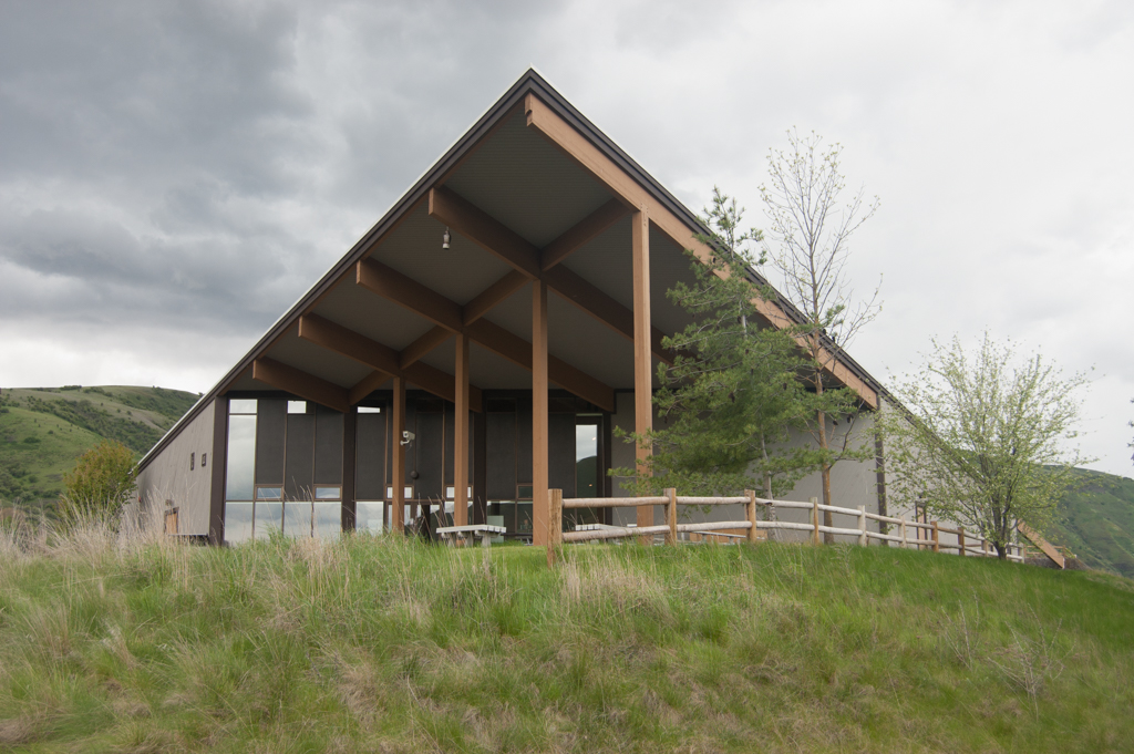
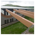
The comprehensive design presented and approved in October 1973 was rigorously geometrical and featured “earthshaping.” The original site plan shows a triangular building, a triangular entry terrace, a circular dance plaza, and a circular drop-off drive integrating angled bus parking spaces that appear to have been positioned by centrifugal force. A cardboard model and elevations show the building embedded in the landscape. This is achieved by framing the central entrance with angular berms reaching up toward the low edge of the roof. From here the gently pitched, triangular shed roof rises up to the northeast, pointing up the Clearwater Canyon. On the northwest side of the entrance, the angular berm rising in the same plane as the roof—but held back from the building to allow windows—is connected visually with angled, glue-laminated beams in the same plane. On the southeast side, the berm rises up to the wall and then wraps around the building’s corner, separating outdoor areas from the “visual and aural pollution” of the highway.
The floor plan of the approved design is an equilateral triangle subdivided into four identical equilateral triangles. The entrance leads through a small vestibule to a point of the central triangular space, which contains a multi-level lobby and multipurpose space. From here, a glass wall affords views out to the second triangular space, a large terrace sheltered by the apex of the roof. The third triangular space is subdivided into an auditorium and restrooms, and the fourth is subdivided into an exhibition space and offices including a partial basement level below.
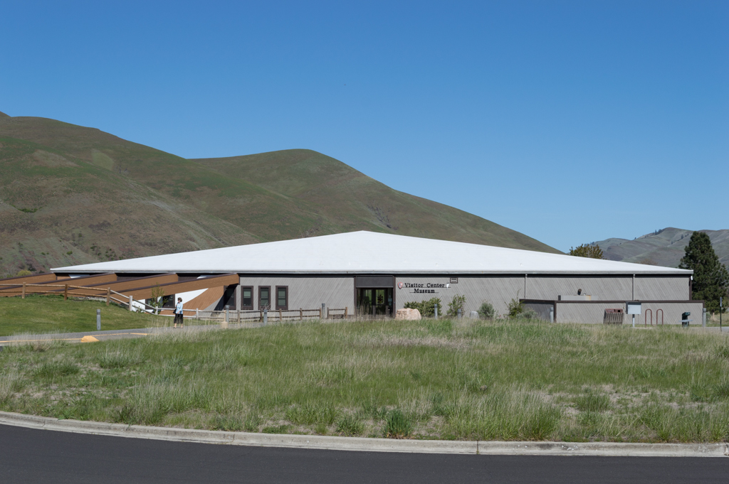
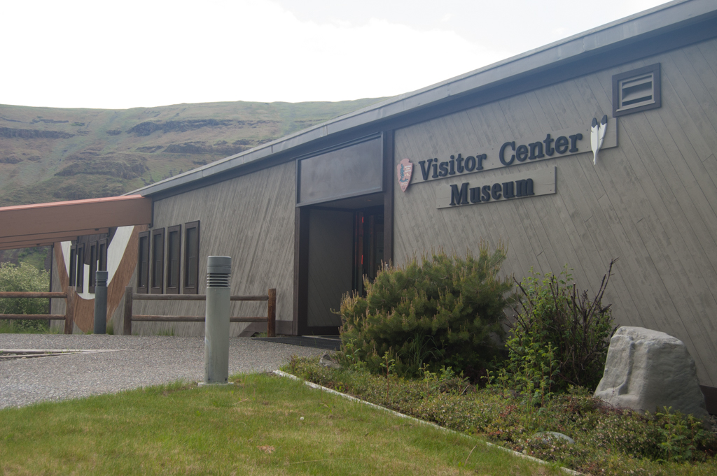
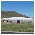
As built, the visitor center does not include everything that designers had envisioned, but the essential features are present. Key to the success of the design is its location and integration of the building with the landscape. The visitor center stands dramatically at the crest of a bluff above the Clearwater River where the raised prow of the roof points up the canyon as the earth slopes away. Not only does this location allow a dramatic relationship with a spectacular landscape and view of the historic Spalding site below, but it also avoids disturbing the historic landscape and allows the building to be highly visible and accessible to visitors traveling along U.S. Highway 95. The site design retains the circular drop-off drive, triangular entry terrace, and beam-connected berm to the northwest of the entrance. The as built floor plan is similar to that of the final design with the exception of the central space, which is now all on one level and no longer triangular. Nonetheless, with its information desk, a bookstore, and displays that include a mural, canoes, and touchable objects, the room performs well as a dynamic, interactive, multipurpose space that offers a dramatic view through a glass wall to the terrace and expansive Clearwater Canyon.
Because the Spalding Visitor Center is intended to communicate the connection the Nez Perce people have with the natural world, Nez Perce consultants and designers chose to use natural materials, predominantly wood. Most visible are exposed glue-laminated wood columns and beams, tongue-and-groove roof decking whose underside is exposed as ceilings, and diagonal tongue-and-groove exterior siding. The modernity of the visitor center design is intended to represent the Nez Perce as modern, contemporary, forward-looking people. This was the skeptical modernism of the 1970s that eschewed minimalist formalism in favor of a more inclusive, complex architecture that was ready to embrace the natural world, express materiality, and accommodate human inhabitants and their particular cultural and social activities.
The earthen berms, triangular form, natural materials, and modernism, which here work in concert to embody the Nez Perce people, are repeated at other sites in the park, where they create aesthetic and symbolic coherence across the National Historical Park as a whole. One such example is the White Bird Battlefield interpretive shelter, whose triangular roof points out towards the battlefield below but also connects the site back to the park headquarters and visitor center at Spalding.
References
Applegate, Robert, Jeffrey A Johnson, Sarah Casper, and Tabitha Erdey. Finding Aid: Nez Perce National Historical Park Resource Management Records. National Park Service. 2011. http://www.cfc.umt.edu/cesu/Reports/NPS/WSU/2011/11_12McCoy_NEPE_archives_%20finding%20aid_rpt.pdf.
Catton, Ted. “Chapter Two: Administrative Development.” In Nez Perce National Historical Park Administrative History. National Park Service. September 1996.
Design Philosophy Outline: Spalding Visitor Center, Nez Perce National Historical Park, Idaho. 1973. National Park Service, Nez Perce National Historical Park; Nez Perce NHP Resource Management Records, Box 3, Folder 9.
Kusek, R. J. Design Analysis: Nez Perce Visitor Center, Spalding, Idaho. July 31, 1973. National Park Service, Nez Perce National Historical Park; Nez Perce NHP Resource Management Records, Box 3, Folder 9.
National Park Service. A Master Plan for Nez Perce National Historical Park, Idaho. National Park Service. June 1968. http://www.nps.gov/parkhistory/online_books/nepe/master_plan/index.html.
National Park Service. Strategic Plan for Nez Perce National Historical Park and Big Hole National Battlefield. October 17, 2007. http://www.nps.gov/nepe/learn/management/upload/StratPlan_2008_2012.pdf.
National Park Service Denver Service Center. Construction Drawings: Spalding Headquarters Development [half-size drawing set]. May 1, 1979. Nez Perce National Historical Park; Nez Perce NHP Resource Management Records, Cab 1, Drawer 8, Folder 2.
National Park Service Denver Service Center. Development Concept Plan – Spalding Site, Nez Perce. October 1973. Nez Perce National Historical Park; Nez Perce NHP Resource Management Records, Cab 1, Drawer 1, Folder 1.
National Park Service Denver Service Center. Nez Perce Comprehensive Design October 10-29, 1973. Nez Perce National Historical Park; Nez Perce NHP Resource Management Records, Cab 1, Drawer 8, Folder 2.
National Park Service Denver Service Center. Planning and Design Directive: Visitor Center and Maintenance Building Development, Spalding Headquarters, Nez Perce National Historical Park. February 21, 1973. Nez Perce National Historical Park; Nez Perce NHP Resource Management Records, Box 3, Folder 9.
National Park Service Pacific West Region. Nez Perce National Historical Park Museum Management Plan. 2005. http://www.nps.gov/parkhistory/online_books/nepe/nepe_mmp.pdf.
Outline of Construction Materials, Finishes and Equipment, Spalding Headquarters Development, Nez Perce National Historical Park. n.d. [1976 or later]. National Park Service, Nez Perce National Historical Park; Nez Perce NHP Resource Management Records, Box 3, Folder 9.
Planting: Visitor Center and Maintenance Area, Nez Perce National Historical Park. n.d. [c. 1973]. National Park Service, Nez Perce National Historical Park; Nez Perce NHP Resource Management Records, Box 3, Folder 9.