Conceived as an urban revitalization plan by Brooke H. Duncan (1887–1950), a civil servant who became city planning director, this project centralized the city’s government, which had been housed in several scattered buildings. The seven-square-block site on eleven acres, a “blighted” and crowded African American neighborhood, was selected because of several factors: the land could be acquired cheaply; the plan would clear a section of slums considered too close to an expanding downtown business sector; traffic circulation could be expanded with the construction of Loyola Avenue; and abandoned railroad tracks could be used for new expressways. Instant urban improvement was the goal. The state and city buildings, constructed mostly of glass and beige limestone, with the clean lines and smooth surfaces popular in the 1950s, are placed—also typically for the 1950s—around an asymmetrically shaped green space (Duncan Plaza) and approached by diagonal pathways. The buildings include City Hall (1956; OR95), designed by Goldstein, Parham and Labouisse, with Favrot, Reed, Mathes and Bergman. The same firms, with the addition of August Perez and Associates, produced the State Supreme Court and the State Office Building, both dating from 1958 and demolished post–Hurricane Katrina, and the Civil Court (1959). The New Orleans Public Library (OR96) of 1958 anchors the downtown side of the complex.
Although several of these civic buildings were undistinguished, their symbolic value was great, demonstrating the city’s desire to show a progressive face. However, the modern design provided the grounds for one of the critiques aimed at the complex: namely, that it made no effort to fit in with traditional New Orleans architecture—an unpopular move in this city. Others, including Mayor deLesseps “Chep” Morrison, described the project as a “dazzling complex” with “glistening” buildings. Duncan Plaza has been relandscaped several times, each without aesthetic success or public approval, if measured by use. In 1986, it was refurbished with a pavilion by architect Arthur Q. Davis, based on a slave hut from Melrose Plantation in Natchitoches. Another redesign is expected in 2018.
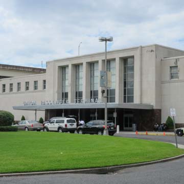
One block upriver from this complex and separated by the Hyatt Hotel are the fourteen-story Federal Office Building (1961, Freret and Wolf; August Perez and Associates; Mathes, Bergman and Associates) and the Union Passenger Terminal (UPT) of 1954 by Wogan and Bernard, with Jules K. de la Vergne and August Perez and Associates, which replaced the Louis Sullivan–designed station (the UPT consolidated into this new building the city’s several train stations). The terminal’s best features are the four brilliantly colored interior fresco murals, each measuring more than 60 × 8 feet, completed in 1954 by Conrad Albrizio (1894–1973), a social commentary on the history of Louisiana as depicted in four different time periods. The murals were restored in 2010.


