


Whether or not its geographic location in Cambridge was truly central, Central Square was a hub for commercial activity and transportation connections at the turn of the twentieth century. (It continues to be an important neighborhood for business and bus lines.) The area’s first horsecar line ran from Central to Bowdoin squares. Populated by business, industry, and its workers, Central Square was urbanized by the end of the nineteenth century, with such urbanization fueled in part by the ability for workers to reside in Cambridge and commute to jobs in Boston.
Fewer than ten years following the opening of Boston’s subway, planners and residents determined rapid transit (elevated or underground) across the Charles River to be crucial. As this extension to Cambridge was being considered, there was serious debate about the nature of the line and the number of stations. For some, the priority was express service through much of urban Cambridge: the swift delivery of residents in the suburban reaches beyond Harvard Square to Boston’s center and back home again. For others, however, multiple stops within Cambridge were critical. Even those suburbanites advocating fewer stations, though, identified Central Square as the preferred location for a station between Harvard Square and the Charles River. Not only was Central Square Cambridge’s commercial center, it also provided connections to existing streetcar lines and, thus, to streetcar suburbs like Brookline and Newton.
In 1907, the Charles River crossing—known as the Longfellow Bridge—was completed. The rapid transit crossing along its center, however, was not put to use until 1912, when the Cambridge section of the Cambridge-Dorchester line first opened—the first extension phase of what is today known as the Red Line. Ultimately, the Cambridge-Dorchester line would provide two stations between Harvard Square and the river: Kendall/MIT Station and Central Station.
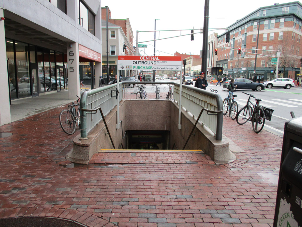
Central Station’s primary subway structures are portals, openings carved into the sidewalks that provide stair access to down to the platforms; they are delineated by half-walls and marked by an MBTA standard graphic sign on iron posts. The inbound portal is located on the south side of Massachusetts Avenue, midway down the block between Western Avenue and Pearl Street. Half-walls with a pink granite base and light green-painted rails define the entrance/exit on two sides of the long rectangular sidewalk cutout. A sign rises above each stair on iron posts, topped by decorative iron work, also light green-painted. The layout allows passengers approaching from either direction to descend easily, with one set of stairs facing roughly west and one facing roughly east. Down one flight, the stairs meet at a wider stairwell perpendicular to the first flight, which brings the passenger down another level to the fare gates and platform. The outbound portal is located on the north side of Massachusetts Avenue at the corner of Prospect Street. One set of stairs, on which a descending passenger faces east, is defined on three sides by iron rails in a pink granite base; the Central Station sign hovers above the portal on iron posts.
Central Station was modernized in 1986, a renovation that included cosmetic upgrades (such as the installation of art works) but also the substantial extension of station platforms in order to accommodate longer trains and a greater volume of passengers. The modernization also included construction of two secondary subway structures for the inbound platform. The first is a lozenge-shaped structure with copper roof and glass walls on three sides that shelters an ascending escalator; the second is a square structure with hipped copper roof and glass walls on four sides that contains an elevator.
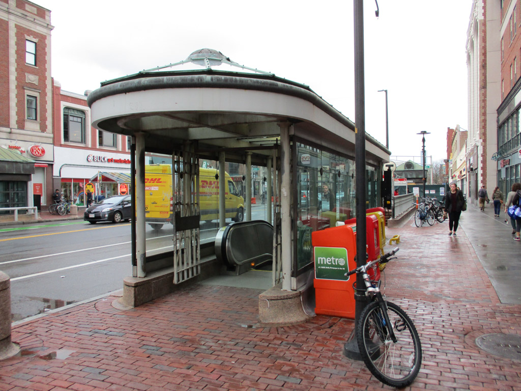
Secondary subway structures for the outbound platform are located on the north side of Massachusetts Avenue on the stretch of sidewalk between Prospect and Essex streets. A subway portal on the corner of Massachusetts and Essex is defined by the pink granite and painted iron railing half-walls on three sides, with two flights of stairs facing west for descending passengers. Other secondary subway structures are twins to those across the street: a lozenge-shaped escalator shelter and a small, square elevator house. Additional MBTA structures in the neighborhood include bus shelters, one located on either side of the street. These open structures feature colored-glass roofs.
Central Station’s subway portals take up relatively little space on the commercial corridor, where most lots have long been filled by two- to five-story mixed-use structures with first-floor shop fronts largely characterized by large, high windows. The buildings are predominantly brick, which is typical for Boston and its surrounding areas. While the Central Square subway structures themselves are not made of brick, they reflect the materiality of the neighborhood in their decorative painted ironwork, a nod to the articulated and painted iron surrounds of street- and upper-level windows.
Down two flights of stairs, inbound and outbound platforms are located on a single level, separated by the rails for both routes and, in the center, a white-painted arcade wall. Between the wall’s arches, one can view the passengers waiting to travel in the opposite direction. Where each arch meets, a white ceramic tile is mounted, featuring a molded depiction of an object or artifact. This collection of tiles, Circle Square by Dennis Storrs and Dennis Cunningham, is part of the Arts on the Line program. Its presence is not immediately obvious; however, its references to the neighborhood’s heritage aim to orient the passenger-in-waiting, and the tiles add visual texture to the station.
The platform walls are clad in off-white subway tile. At regular intervals recessions are built into the walls, which provide seating and also create frames for wall murals. Artist Elizabeth Mapelli used colorful fused-glass tiles to create a backdrop for the benches—another Arts on the Line work titled Various. These interior artworks, in combination with the standard MBTA graphic murals, echo the varied materiality of the building stock and the historic and contemporary character of Central Square. Its minimal aboveground structures defer to the vibrancy and volume of everyday sidewalk activity and its legacy of multimodal transit.
References
“Central Square Final Report 2013.” Cambridge Community Development Department. Accessed January 15, 2018. http://www.cambridgema.gov/.
Cheney, Frank. Boston’s Red Line: Bridging the Charles from Alewife to Braintree. Charleston, SC: Arcadia Publishing, 2002.
Cheney, Frank, and Anthony M. Sammarco. Trolleys Under the Hub. Dover, NH: Arcadia Publishing, 1997.
Cudahy, Brian J. Change at Park Street Under: The Story of Boston’s Subways. Brattleboro, VT: Stephen Greene Press, 1976.
“Map 08: South of Central Square.” Cambridge Arts Council, City of Cambridge. Last modified 2002. Accessed January 6, 2018. http://www2.cambridgema.gov/.
Massachusetts Transportation Library. Massachusetts Highway Commission. Annual Report – Massachusetts Bay Transportation Authority 1984. Boston: Massachusetts Highway Commission, 1984.
Massachusetts Transportation Library. Massachusetts Highway Commission. Annual Report – Massachusetts Bay Transportation Authority 1986. Boston: Massachusetts Highway Commission, 1986.
Most, Doug. The Race Underground. New York: St. Martin’s Press, 2014.
O’Connell, James. The Hub’s Metropolis: Greater Boston’s Development from Railroad Suburbs to Smart Growth. Cambridge: MIT Press, 2013.
Sanborn, George M. “A Chronicle of the Boston Transit System.” Massachusetts Institute of Technology. Accessed January 15, 2018. http://web.mit.edu/.