

Kendall Station; Cambridge Center/MIT Station
Kendall/MIT Station


1908–1912; 1985 renovation, Ellenzweig Moore and Associates. 283-325 Main St.


The historic and contemporary subway structures of Kendall/MIT Station reflect the necessity of the stop as an access point to this industrial Cambridge neighborhood. Opened in 1912 as part of the first extension phase of the Cambridge-Dorchester Line (now known as the Red Line), the original station shepherded workers to a grittier Kendall. In the twenty-first century, Kendall remains an area with more workplaces than residences, and the station is a commuter gateway.
Kendall/MIT Station, along with Charles, Central, and Harvard stations, comprised the early 1900s Cambridge Tunnel extension, which expanded upon the original Tremont Street Subway and connected Boston to Cambridge across the Charles River. The station was originally known as Kendall, and later incorporated Massachusetts Institute of Technology (MIT) into its name in the late 1970s. When it opened, the station was a multimodal stop accommodating street-level trolley travel as well as underground rapid transit. Above the subway station at Kendall, a curved trolley transfer station included a combination station shelter (an outdoor, sheltered waiting space) and a fully enclosed head house. The one-story brick head house had tall multi-light windows and entrance/exit doors, and was nestled between Kendall Square structures. The roof’s line curved in response to the street that defined the edges of the site and the trolley tracks that informed its design and function.
In 1985, the station was modernized as part of an ongoing phased effort by the MBTA to make existing stations standardized, accessible, more efficient, and more attractive. Kendall’s modernization was additionally supported by the Cambridge Redevelopment Authority, as part of its Cambridge Center Urban Initiative (Cambridge Center being another name for the Kendall neighborhood). As with any MBTA modernization, measures were taken to upgrade both the interior and exterior, including new head house design and construction, subway platform extension, accessibility, graphic murals, public art, and general cosmetic maintenance and improvements.
Today, Kendall/MIT station has two primary entrances/exits, one for the inbound route and one for the outbound. The primary inbound subway structure is located on the south side of Main Street and is a stand-alone head house, a one-story Postmodern box clad in pink granite. A glass triangular prism runs the length of both the north-south axis and the east-west axis of the head house’s roof. The north-south prism extends over the doors on either side of the structure, creating a shallow gable-roofed eave.
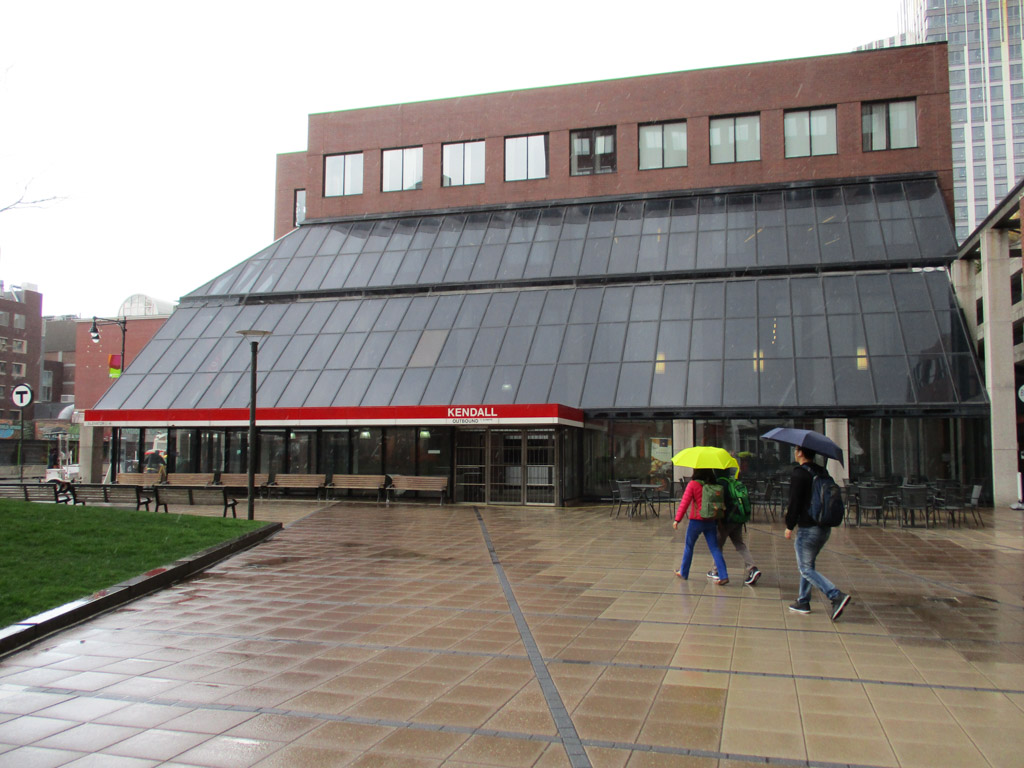
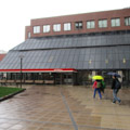
The primary outbound subway structure is located on the north side of Main Street and is an integrated head house. The MBTA entrance/exit is incorporated into a hulking complex, Kendall Center, which includes a hotel (designed by Moshe Safdie and Associates), an MIT-Harvard bookstore (the COOP), the Microsoft New England Research and Development (NERD) Center, other private business and office spaces, and restaurants. Kendall Center is a mass of right angles clad in red brick veneer. The Kendall/MIT station metal roof starts three stories up and slopes down in two angled surfaces, forming a sort of half-gambrel roof. This shelter creates a multistory outdoor corridor through which pedestrians can access other parts of the complex; additionally, it creates an outdoor shelter, which harkens back to the historic multimodal structure, where passengers would wait for the trolley at the surface level. (Today, there is no trolley running through Kendall; however, an MBTA bus stop and multiple private shuttle stops are nearby.)
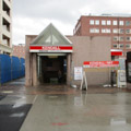
In addition to the primary inbound and outbound structures, Kendall Station also includes subway portals for each direction. The secondary inbound structure, located on Main Street, about one block east from the primary structure, features a standardized graphic sign sitting one-story high on rectangular dark steel columns above a rectangular stair entrance carved into the sidewalk. The portal is enclosed on three sides by granite half-walls. Half of the portal entry is sheltered by a gently arched granite roof that rests on top of the half-walls. The secondary outbound portal is similarly marked by a one-story-high graphic sign, this one mounted on thinner, brushed steel columns and enclosed on three sides by pink granite half-walls and no roof.
For both primary entrances, passengers descend two flights of stairs to reach the platforms, which are separated by the rails and an arcade wall. On either side, standard white subway tile clads the wall, with a solid stripe of uninterrupted red Plexiglas and a solid stripe of white Plexiglas with the station name and directional cues running toward the top of the tiled wall.
These stripes, in addition to serving as wayfinding, also frame the graphic murals that became standard in modernized and new MBTA stations. Relating the underground station to the heritage of the neighborhood above, the Kendall/MIT graphic murals consist of a timeline (comprising text and black-and-white images) of the history of the neighborhood as an industrial center for Cambridge, of MIT as an institution, and of the technological and scientific advancements that took place at or in relation to the school.
In addition to the visual interest of the graphic murals, passengers waiting on the platform can also enjoy the most unique Arts on the Line piece in Boston’s subway system: an interactive musical artwork, The Kendall Band – Kepler, Pythagoras, Galileo by Paul Matisse.
While the nature of the neighborhood’s workplaces has changed since the early twentieth century—today computing and biotech companies are the industries at play—the Kendall/MIT Station remains a portal for commuters. Its interior treatments speak more explicitly to this; still, Kendall’s subway architecture—occupying as little aboveground space as possible, especially its primary outbound structure—speaks to the seriousness of work taking place in the neighborhood, requiring built resources that integrate easily into the existing urban fabric and also leave room for future development as industry progresses.
References
Cheney, Frank. Boston’s Red Line: Bridging the Charles from Alewife to Braintree. Charleston, SC: Arcadia Publishing, 2002.
Cheney, Frank, and Anthony M. Sammarco. Trolleys Under the Hub. Dover, NH: Arcadia Publishing, 1997.
Cudahy, Brian J. Change at Park Street Under: The Story of Boston’s Subways. Brattleboro, VT: Stephen Greene Press, 1976.
“Tour the Art. Fact Sheet: Arts on the Line.” Cambridge Arts Council, City of Cambridge. Accessed January 6, 2018. http://www2.cambridgema.gov/.
Massachusetts Highway Commission. Annual Report – Massachusetts Bay Transportation Authority 1984. Boston: Massachusetts Highway Commission, 1984.
Massachusetts Highway Commission. Annual Report – Massachusetts Bay Transportation Authority 1985. Boston: Massachusetts Highway Commission, 1985.
Massachusetts Highway Commission. Annual Report – Massachusetts Bay Transportation Authority 1985. Boston: Massachusetts Highway Commission, 1986.
Most, Doug. The Race Underground. New York: St. Martin’s Press, 2014.
O’Connell, James. The Hub’s Metropolis: Greater Boston’s Development from Railroad Suburbs to Smart Growth. Cambridge: MIT Press, 2013.
Sanborn, George M. “A Chronicle of the Boston Transit System.” Massachusetts Institute of Technology. Accessed January 15, 2018. http://web.mit.edu/.
Simha, O. Robert. MIT Campus Planning, 1960-2000: An Annotated Chronology. Cambridge: MIT Press, 2001.
Sullivan, Charles M. “Draft Landmark Designation Study Report Kendall Square Landmark Group: Kendall Square Building, 238 Main St. J. L. Hammett (Rebecca’s) Building, 264 Main St. Suffolk Engraving (MIT Press) Building, 292 Main St.” Cambridge Historical Commission. Accessed February 18, 2018. https://www.cambridgema.gov/.
Writing Credits
If SAH Archipedia has been useful to you, please consider supporting it.
SAH Archipedia tells the story of the United States through its buildings, landscapes, and cities. This freely available resource empowers the public with authoritative knowledge that deepens their understanding and appreciation of the built environment. But the Society of Architectural Historians, which created SAH Archipedia with University of Virginia Press, needs your support to maintain the high-caliber research, writing, photography, cartography, editing, design, and programming that make SAH Archipedia a trusted online resource available to all who value the history of place, heritage tourism, and learning.