


Boston boasts the first subway system in the United States. Familiarly known as the T, it made its first short run (under one mile) in September 1897. Significantly, it has continued operation since, and is one of the few legacy subway systems in the country. Its predecessors in Boston—other modes of transportation like the omnibus, horsecar, electric streetcar, and elevated rail—moved people en masse but relied on available surface area and the city’s existing maze of streets.
Boston’s below-grade subway offered rapid transit as well as relief from traffic congestion and built visual clutter. Taking rapid transit underground meant another way to travel without interfering with existing aboveground means. Plus, investing in a subway system rather than an elevated railway system guaranteed a reduction in multistory structures and infrastructure for trains that might obscure business entrances and residents’ views, and introduce more noise pollution.
The resolution to move rapid transit underground necessitated clear visual indicators of subway stops at surface level. Certain aboveground concerns likely influenced approaches to station entrance/exit design that valued subtlety and integration into the neighborhood built environment. Generally, concerns expressed by business owners who faced disruption from temporary rapid transit construction processes or more permanent built structures may have informed approaches to the system as a whole and how aboveground markers of that system looked.
More specifically, the location selected for the first stretch of subway, and its associated structures, set a precedent for respectful, site-specific design. Built under the edges of the Boston Common, the run of track elicited excitement but also controversy. The Common was—and remains—one of the oldest public spaces in Boston, a nearly sacred shared amenity, historically a grazing and a gathering place. For some, using the temporarily destructive cut-and-cover method of subway construction, even on the periphery of the Common, was an outrageous act. The stately, temple-like head houses located at today’s Park Street and Tremont stations acted as some salve for the now well-healed wound. The sturdy one-story structures made of granite block, roughly one bay by three bays, stand as reassuring and respectful entryways. Square pilasters define their doors, and, toward the metal roof, dentils and clerestory-like windows add an understated level of embellishment, appropriate to the nation’s historic first span of subway track and in deference to the even more historic Boston Common.
This architectural specificity to station site—or, more broadly, neighborhood—has rippled outward from the late-nineteenth-century Park Street and Tremont stations to effect the dozens of stations that followed. Heterogeneity characterizes the architecture throughout the system. Since its inception, the T has responded to the nature of the city’s neighborhoods. To say that Boston is a city of neighborhoods is nothing new, nor does it make Boston unique. However, recognizing that the T is informed by neighborhood character in both its routes and its structures makes for a clearer understanding of the system’s architectural variety and its interior treatments.
Just as much as the first subway structure designs set a precedent, responding to physical context and fabric, the first station locations, perhaps unavoidably, also set a precedent. From the end of the nineteenth century to present day, subway station placement has been determined by the locations of commercial and industrial centers, and by residential nodes. Prior to the creation of the T, other modes of transportation carried those who could afford to settle outside of the city—in streetcar suburbs and other distinctly residential areas—to and from the commercial center. The T continued this service, with stations established to deliver people to the places in which they worked, shopped, and lived.
Today’s Red Line, originally known as the Cambridge-Dorchester Line, has expanded in multiple phases, fueled by growing residential populations (commuters) as well as growing industry and job markets. (This applies to all of the MBTA Lines: Green, Orange, Blue, and Silver.) The first extension phase took place in the 1910s, moving across the Charles River to an increasingly urban Cambridge, with denser and more industrial development closer to the river and more residential and agricultural areas farther west. The second extension phase took place in the 1920s, and could be called the Ashmont extension, terminating in Ashmont, serving residential neighborhoods in the south of the city and beyond. New Red Line stations were not added during the Depression or World War II, nor were they added in the immediate postwar decades, as more people were looking to settle outside of the city, and heavy investment in highway construction (versus public transportation) made suburban life easier and more appealing.
The third Red Line extension phase, known as the South Shore extension and the Braintree branch, also serves neighborhoods in the south of Boston proper and farther afield. These stations were not built until the 1970s and 1980s, following the creation of today’s management entity, the Massachusetts Bay Transportation Authority (MBTA). The original subway structures and those of the first two extensions were heterogeneous, focusing more on responding to their site than creating a systemwide architectural identity. With the South Shore extension, however, there was some coherence between the stations, which were all located in less dense suburban-urban centers and which took Brutalist architectural cues.
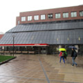
The final significant extension phase to date has been the Northwest Extension or the Alewife Extension. Completed in the mid-1980s, it expanded service to Alewife Station, the northern Red Line terminal that includes a parking garage with over 2,500 spaces. The architectural treatment of the Northwest Extension stations is varied; however, Porter Station suggests continued interest in a systemwide architectural identity, with its soaring form in glass, steel, and granite asserting itself as much as the massive forms of the South Shore Extension structures.
In 1964, the Massachusetts Bay Transportation Authority (MBTA) was created, consolidating the management efforts of the T and creating master plans for extending and improving service and, by extension, subway facilities. A certain uniformity of a smaller scale was established and systematically implemented in phases: local architecture firm Cambridge Seven Associates created a standard for graphic identity across all MBTA rapid transit (including buses) and the MBTA developed a modernization program for existing stations, encompassing aesthetic, accessibility, and other physical upgrades. This program comprised two different tracks: a smaller program consisting of cosmetic improvements, and a full modernization program, which did not necessarily require new construction or total renovation, but did consist of some sort of capital project, largely accessibility upgrades and platform extensions to accommodate new or additional rolling stock.
Even as the newly formed MBTA made plans for a more cohesive T, heterogeneity persisted, and was even enforced. A component of the new standards was the graphic wall mural, installed at new and modernized stations. These two-dimensional interior art pieces celebrate the specificity of the station’s neighborhood with photographs, illustrations, and text depicting the area’s heritage, orienting riders with visual cues more explicit than architectural form and style.
During the MBTA’s tenure, one-off artworks were also installed in some stations. The Arts on the Line program was begun in the 1980s for the Red Line specifically, and administered through the city of Cambridge. This program consisted of commissioning station-specific pieces of art, especially in connection with the new facilities of the Harvard-Alewife extension of the 1980s and 1990s, and with modernized stations during that time.
Variety can also be found even among the T’s subway structure types. Three different entrance/exit facility types are found throughout the system, often with some combination of the four at a single stop. The station shelter, found at a surface (aboveground) station stop, is comparable to a bus shelter, with one to three walls and typically a shed roof. The majority of the Green Line stops west of Copley are surface stops with station shelters only.
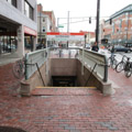
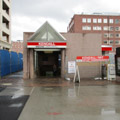
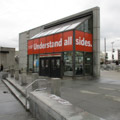
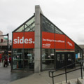
The subway portal is an entrance/exit with cuts into the existing sidewalk and stairs leading to a below-grade interior station; the only aboveground structure consists of posts, signs, and half-height walls or railings. This entrance/exit type is used at Central Station, in a neighborhood with sidewalks wide enough to accommodate a portal without interfering with foot traffic, but with too little street-level space to accommodate a full subway structure. The subway head house is an aboveground structure fully enclosed by walls, with interior space at street level (even if only a landing) and, typically, doors that may be closed to completely seal or make inaccessible the structure.
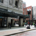
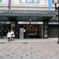
For some T stations, head houses or portals are integrated into existing buildings, either fully incorporated, as with the Downtown Crossing Station entrance in the ground floor of the former Filene’s Department Store (1911–1912, D.H. Burnham and Co.), or are additions to structures, new or existing, as with the Kendall/MIT entrance, part of Cambridge Center, a mixed-use complex that includes the Moshe Safdie–designed Boston Marriott Cambridge (1985), located between Main Street and Broadway in Cambridge.
While any line of the T would evidence the variety of Boston-area neighborhoods and, thus, subway structures, the Red Line is particularly well-positioned as a case study for investigating the Boston subway system. It encompasses the variety of neighborhood types, building typologies, architectural styles, materials, and graphics and arts treatments that illustrate the built resources of the T as a whole. Additionally, the Red Line includes the historic first stop of the T: Park Street Station, which intersects with three of the four other T lines (Green, Orange, and Silver); connects with other modes of transportation at the historic South Station, a node for train and bus travel; and, moving from Alewife at one end to Ashmont or Braintree at the other, it journeys from suburban to urban and back to suburban again.
Today, the Red Line comprises 21 heavy rail rapid transit stations, discounting a seven-stop surface-level line between Ashmont and Mattapan, on which the Mattapan Trolley operates. In a city of neighborhoods, within a transit system that serves a metropolitan region, it is no surprise that no true architectural identity for the Red Line has emerged. Rather, station architecture is rooted in neighborhood identity first, and the station’s original era second. Just as the streets of Boston are not arranged in grids, the T’s architecture is not uniform or prescribed. Its graphic standards are enough to signal a cohesive system. Beyond that, stations and their architecture may be varied and contextual—artifacts representing neighborhoods’ character and heritage, and the region’s historic development.
References
Boston Landmarks Commission: The Filene’s Complex: Study Report. Boston: City of Boston, 2006.
Cheney, Frank. Boston’s Red Line: Bridging the Charles from Alewife to Braintree. Charleston, SC: Arcadia Publishing, 2002.
Cheney, Frank, and Anthony M. Sammarco. Trolleys Under the Hub. Dover, NH: Arcadia Publishing, 1997.
Cudahy, Brian J. Change at Park Street Under: The Story of Boston’s Subways. Brattleboro, VT: Stephen Greene Press, 1976.
Holleran, Michael. Boston’s “Changeful Times”: Origins of Preservation and Planning in America. Baltimore: Johns Hopkins University Press, 1998.
Massachusetts Highway Commission. Annual Report – Massachusetts Bay Transportation Authority 1965. Boston: Massachusetts Highway Commission, 1965.
Massachusetts Highway Commission. Annual Report – Massachusetts Bay Transportation Authority 1966. Boston: Massachusetts Highway Commission, 1966.
Massachusetts Highway Commission. Annual Report – Massachusetts Bay Transportation Authority 1967. Boston: Massachusetts Highway Commission, 1967.
Massachusetts Highway Commission. Annual Report – Massachusetts Bay Transportation Authority 1968 - 1969. Boston: Massachusetts Highway Commission, 1968.
Massachusetts Highway Commission. Annual Report – Massachusetts Bay Transportation Authority 1970. Boston: Massachusetts Highway Commission, 1970.
Massachusetts Highway Commission. Annual Report – Massachusetts Bay Transportation Authority 1972. Boston: Massachusetts Highway Commission, 1972.
Massachusetts Highway Commission. Annual Report – Massachusetts Bay Transportation Authority 1973. Boston: Massachusetts Highway Commission, 1973.
Massachusetts Highway Commission. Annual Report – Massachusetts Bay Transportation Authority 1975. Boston: Massachusetts Highway Commission, 1975.
Most, Doug. The Race Underground. New York: St. Martin’s Press, 2014.
O’Connell, James. The Hub’s Metropolis: Greater Boston’s Development from Railroad Suburbs to Smart Growth. Cambridge: MIT Press, 2013.
Sanborn, George M. “A Chronicle of the Boston Transit System.” Massachusetts Institute of Technology. Accessed January 15, 2018. http://web.mit.edu/.
Writing Credits
If SAH Archipedia has been useful to you, please consider supporting it.
SAH Archipedia tells the story of the United States through its buildings, landscapes, and cities. This freely available resource empowers the public with authoritative knowledge that deepens their understanding and appreciation of the built environment. But the Society of Architectural Historians, which created SAH Archipedia with University of Virginia Press, needs your support to maintain the high-caliber research, writing, photography, cartography, editing, design, and programming that make SAH Archipedia a trusted online resource available to all who value the history of place, heritage tourism, and learning.