


The Village of Mariemont is a planned residential suburb on the east side of Cincinnati that landscape architect John Nolen designed in 1920–1921. Ground was broken in 1923; that same year the streets were graded and the community’s first building, a non-denominational church, was erected. Mary Muhlenberg Emery was the philanthropist and visionary who wanted to do more than improve the quality of housing; she wanted to build a new town that could become a model for community development. It would provide affordable rental housing, a variety of architect-designed houses, schools, parks, shops, streetcar transportation, and trees. The goal was to create a diverse and attractive community.
The widow of Cincinnati real estate and construction magnate Thomas J. Emery, Mary Emery provided the money to develop her ideal community, with John Nolen as her designer and Charles J. Livingood as her advisor. Nolen’s first plan, for a district of 253 acres, was presented to Emery in 1921 with a title that explained their intentions: “Mariemont, the New Town, Cincinnati District, Ohio: An Interpretation of Modern City Planning Principles applied to a Small Community to produce Local Happiness, a National Exemplar.” Between 1922 and 1925, Nolen expanded the plan to include the Indianview neighborhood on the east and the industrial Westover area on the west, for a total of 420 acres.
The main road cutting through the site of the new community was Wooster Pike (U.S. Route 50) and Nolen used this, along with the distinctive topography of a ravine and a high bluff overlooking the flood plain of the Little Miami River, as the starting points for the design. Following City Beautiful planning principles and the ideals of the Garden City movement, Nolen created a network of roads, parks, building locations, and lot lines that produced the feeling of a small but open community. With mostly cleared farmland as his canvas, he laid out a town square with east- and west-bound traffic lanes in the main road and four additional streets radiating from the square. Serving as Mariemont’s commercial center, the buildings in this part of the village included the inn, theater, and various shops.
Nolen’s landscaping included tree-lined streets and allotment gardens, but he put great emphasis on the creation of scenic vistas. The grandest vista is from the Miami Bluff Park concourse, which looks over the railroad tracks and bridges towards the Little Miami River and the village of Newtown in the distance. Other features included the “lich gate,” built on a path leading from Wooster Pike to the church and cemetery. This small shelter, typical of Norman-period English churches, set the tone for the English countryside flavor of Mariemont.
Northwest of the town center is the village’s most densely populated area, with a school, community church, a small shopping area, and town houses and apartment buildings. South of the square, on the diagonally radiating streets, there are two-story apartment buildings from which extend curving streets of single-family houses. At the edge of the hill, the Miami Bluff Greenspace is a swath of lawn with a stone wall and pergola overlooking the floodplain and the Little Miami River. Dogwood Park, with its carillon, ball fields, and swimming pool, is located southwest of the square. Amid these amenities are single-family detached houses.
While Mariemont was a planned community, Nolen’s scheme included no restrictions on the architectural styles that could be used for its buildings, which were designed by numerous nationally recognized architects from New York, Boston, and Philadelphia. These included designers especially known for their residential work, such as Grosvenor Atterbury, Richard B. Dana, Edmund B. Gilchrist, Lois L. Howe, Louis E. Jallade, Eleanor Manning, and Carl A. Ziegler. Mariemont also features the work of local architects, notably Charles A. Cellarius, who served as Mariemont’s resident architect, a position that gave him national exposure and an invitation to serve on the Committee for House Design at the 1931 President’s Conference on Home Building and Home Ownership.
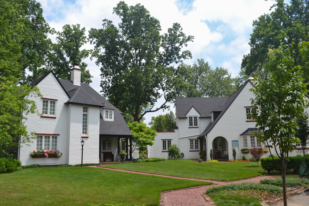
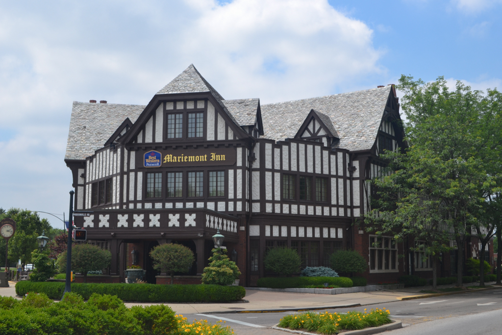
Today, there are over 1,000 architecturally distinctive buildings within the community, displaying styles ranging from Tudor Revival, Colonial Revival, Italian Renaissance Revival, to Bungalow/Craftsman and Art Deco. Reminiscent of a quaint Cotswold village many of the single and double houses feature stucco and half-timbering reflecting the design concepts of the Arts and Crafts movement. The main buildings on the north side of the square, including the V-shaped Mariemont Inn (1925–1929, Zettel and Rapp) and the movie theater with rows of shops on either side, are Tudor Revival. The carillon and community church are in the Norman-Gothic Revival style. The Recreation Center is in the Renaissance Revival style. The two schools on Wooster Pike are red brick in the Georgian Revival style.
In 1979, a 319-acre portion of the village was listed in the National Register of Historic Places. In 2007, a 525-acre area was designated a National Historic Landmark. This included the 80-acre flood plain that was part of the original land purchase and community plan, which designated it for industry and farming. The Village’s corporate boundary today encompasses about 650 acres, and Mariemont’s population in 2010 was 3,380.
Mariemont remains an outstanding example of an American garden suburb, based on English models and demonstrating a masterful integration of architecture, landscaping, and urban design.
References
Rogers, Millard F., Jr. John Nolen and Mariemont, Building a New Town in Ohio. Baltimore: John Hopkins University Press, 2001.
Rogers, Millard F., Jr., “Village of Mariemont,” Hamilton County, Ohio. National Historic Landmark Nomination, 2007. National Park Service, U.S. Department of the Interior, Washington, D.C.
Rybczynski, Witold. City Life. New York: Simon and Schuster, 1995.