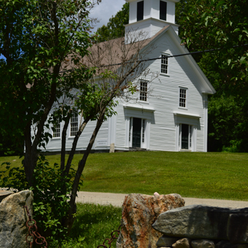
This white, wooden church at an upland crossroads is typical of mid-nineteenth-century churches built in the Green Mountains. It sits at an elevation of 1,800 feet in a stream valley of a tributary of the West River. Methodists commissioned the 30 × 40–foot building to attract a regular circuit rider, and by 1870 it had become a Union church with other denominations. The church has twin entrances on the gable end, a square two-stage belfry, and the eaves, corners, entrances, and belfry are trimmed with an entablature and paneled pilasters. Inside, the entry “porch” area accesses the sanctuary through a pair of doorways and has dual side stairs that lead to the balcony. The sanctuary contains row-seating pews and the pulpit is at the north end. The setting of the simple church is dramatic, as it is ringed with mountains on the west, east, and south.
District No. 2 School, in a style similar to the church, originally stood at a crossroads to the east but was moved around 1980 to a lot facing the church. To the north is a cemetery dating from 1800, and to the south across the road is a farmhouse that is a good example of the notable five-bay-front houses with steeply pitched roofs found in the upper West River Valley in the Landgrove and Weston vicinity. Provided the clearings remain and the stream valley fields continue to be hayed, the church forms the centerpiece of a Vermont mountain town landscape appearing much as it had just before the Civil War.


