

-
 (Photograph by Rich Freitas)
 -
 (Photograph by Rich Freitas)
 -
 (Photograph by Rich Freitas)


Mill Creek Canyon Earthworks is a pioneering stormwater management design overlaid on a public park just east of downtown Kent. Herbert Bayer’s artful landforms shape the floodplain ravine into a stormwater detention facility while revealing the site’s hydrological forces. The two-and-a-half-acre site sits in the northeast corner of the larger 107-acre Mill Creek Canyon Earthworks Park and functions as the park’s entrance. The park was dedicated on September 4, 1982.
The City of Kent was inspired by the King County Arts Commission’s 1978 announcement of a symposium, “Earthworks: Land Reclamation as Sculpture,” in which artists were invited to propose solutions for reclaiming publicly owned sites that had been damaged by mining operations. Faced with the problem of constant flooding from Mill Creek due to silt and debris from development above the future Earthworks site, the City asked the jury to recommend an artist who might be able to assist them. The jury selected Bauhaus master Herbert Bayer.
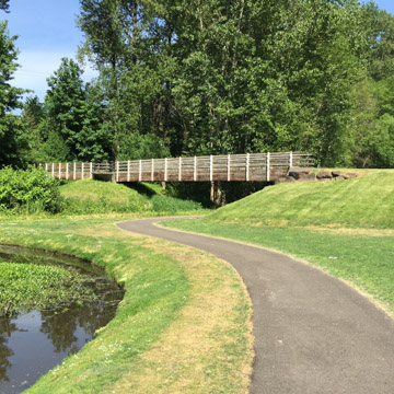
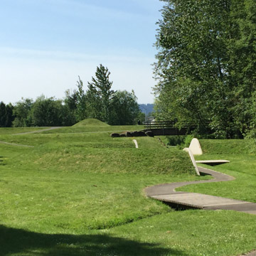
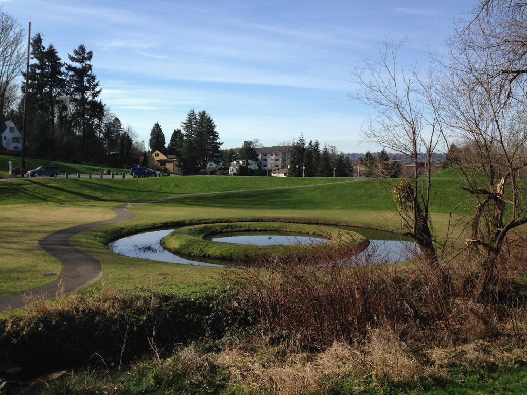
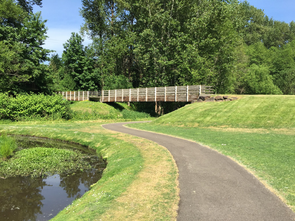
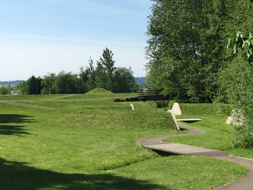
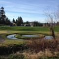
Bayer created a large earthen berm that serves as a dam to detain water during storm events and prevent flooding. A 30-inch pipe allows the creek to bypass the dam during normal conditions and provides an uninterrupted channel for coho salmon. On top of the berm is a conical mound measuring 46 feet in diameter. At the berm’s western base is an additional oval mound with a footprint of 40 by 70 feet. The design’s three primary earthworks are east of the dam and upstream of the creek. Closest to the dam is a circular pond, 90 feet in diameter, with a grass-covered floating ring. During floods the grass ring is consumed and then revealed as the waters rise and recede. Beyond the pond is another conical mound topped with a viewing platform. The conical mound and a second, smaller berm support a wooden bridge approximately 10 to 12 feet above the ground. The bridge spans the detention basin formed by the dam, the smaller berm, and the canyon wall to the north. The third element is a 100-foot-diameter ring-shaped mound. Five feet high, the grass-covered mound is dissected by both the creek and a pedestrian path. Its sides are capped with concrete retaining walls where the two openings have been cut through.
The site is primarily covered in turf grass. Native vegetation, mainly alder trees and understory growth, buffers the canyon’s north and south boundaries. Single rows of poplar trees were planted to the west of each of these stands. Flood water is diverted upstream from the earthworks to a sediment pond on the eastern edge of the site. The pond is not part of Bayer’s design but he channeled water from it through a portion of the site before it rejoins Mill Creek along the canyon’s north side. An emergency spillway located on the northeast side of the dam handles flood waters that exceed eight feet by sending water to the city infrastructure. Otherwise water detained in the basin is reabsorbed by the landscape.
Visitors who enter the site from the parking lot can survey the individual earthworks from the top of the dam. After descending into the basin, the features reveal themselves as one progresses through the park. Bayer’s use of basin and mound, form and void, hidden and revealed shape the visitor experience while forming the basis of the site’s green infrastructure. The relationship of the earthworks to the flood waters’ rise and fall further contribute to the public’s experience of the site. The site’s primary circulation route is a 6-foot-wide asphalt path that winds east-west through and around the earthworks. Bayer did not design the path or other park furnishings but provided input on their materials.
Bayer taught both typography and graphic design during his tenure at the Bauhaus. He immigrated to the United States in 1938 and established a successful practice in New York that included graphic design and exhibition design. Bayer is not regarded as an environmental artist but his work in Aspen for the Aspen Institute in the 1950s is regarded as an early precedent for the land art movement. His proposal for the Kent site was featured along with seven other artists during the King County Arts Commission’s symposium in 1979 and was one of only two designs, along with Robert Morris’s Untitled (Johnson Pit No. 30), that were built.
A restroom facility designed by Jones and Jones was added in 1985. The design was approved by Bayer shortly before his death and boasts the city’s first green roof. The roof also provides a viewing platform over the park. In 2006, the Washington State Department of Ecology notified the city that the park had to meet the requirements for a 10,000-year flood event instead of the 100-year event for which it was designed. To meet the new requirements, the dam was elevated two feet in 2008. The site received a $70,000 grant from the National Trust for Historic Preservation in 2010 to support a two-year restoration.
Mill Creek Canyon Earthworks was nominated for local landmark status by the Kent Arts Commission and was designated the city’s first landmark in 2008. The site was deemed significant enough that the eligibility rule requiring properties to be forty years or older was waived.
References
Baird, C. Timothy. “A Composed Legacy.” Landscape Architecture 93, no. 3 (March 2003): 71-75, 89.
Beardsley, John. Earthworks and Beyond. New York: Abbeville Press, 2006.
Hunter, Steve. “Earthworks Park the subject of… earthwork.” Kent Reporter, July 19, 2008. Accessed July 31, 2016.
King County Archives. “King County Earthworks: Land Reclamation as Sculpture.” Accessed July 31, 2016. http://www.kingcounty.gov/.
Maryman, Brice. “Mill Creek Canyon Earthworks.” City of Kent Landmarks Commission Landmark Registration Form, March 25, 2008. King County Historic Preservation Office, Seattle, Washington.