Port Gamble, established in 1853 in the midst of the nation’s greatest reserve of old growth timber, was one of the earliest and most important lumber-producing centers of the Puget Sound region. In fact, the town and the associated mill were at the forefront of the development of the Pacific Northwest’s timber industry and international trade during the second half of the nineteenth century. The mill is no longer extant, but the town remains, and although some buildings have been lost, the town’s vernacular residential architecture and its institutions still serve as tangible reminders of the early settlement and its once-thriving economy. Of all the communities in the Puget Sound region founded and built prior to the appearance of the transcontinental railroads in the 1880s, none remains as unaltered as Port Gamble.
Establishing the town’s economic prosperity did not happen overnight. In July 1853, Captain William C. Talbot of Pope and Talbot, a San Francisco–based firm operating in Washington as the Puget Mill Company, arrived in Puget Sound to search for a good sawmill site. Talbot and his partners—Andrew J. Pope, Charles Foster, and Captain Josiah P. Keller—all belonged to families that had logged and built ships in Maine since the American Revolution. Talbot decided to situate the mill and the associated town on a small yet heavily forested peninsula on the west side of Port Gamble Bay, five miles from the mouth of Hood Canal. The site was strategic: Talbot knew that the Hood Canal opened into Admiralty Inlet, and thence into the Strait of Juan de Fuca and eventually into the Pacific Ocean. Port Gamble Bay, about two-and-a-half miles long and three-quarters of a mile wide, with an average depth of thirty feet, was well-suited to shipping. Its location near the northern end of Puget Sound significantly shortened the trip to port for sailing vessels.
In September 1853, Captain Keller arrived at Port Gamble in a schooner loaded with machinery for the new steam-powered sawmill. A week later the muley saw and mill were in operation. Improved machinery was installed in January 1854. The mill, bunkhouse, cookhouse, and general store were soon joined by wharves, dwellings, and shops—all owned by the company. In 1858, a second mill was erected, along with a new mill dock and a new merchandise wharf. Everything was clustered on a sand spit at the base of the bluff on the west side of the bay.
The community remained entirely on the spit for about five years, which facilitated the transportation of timber to and from the mill and afforded the new settlement some protection from Indian raids. The settlers were attacked in 1858, but held their own until the arrival of the steam sloop USS Massachusetts. Twenty-six natives and one sailor, Gustavus Englebrecht, were killed in that encounter. Englebrecht was the first person to be buried in the cemetery on the bluff. Peace between whites and Indians on the Puget Sound was established shortly thereafter.
By 1858, the Puget Mill Company began attracting families to Port Gamble after developing a town on the land at the top of the bluff that had been opened up by logging along the west side of the bay. That year, resident manager Josiah Keller platted a portion of this land and established the framework for the town: a gridded street system anchored by Rainier Avenue, which ran north and south along the top of the bluff. The mill site was accessed from the north end of this street, where the commercial center now stands. The layout included all the lots along and between Rainier Avenue and the next street to the west, Olympic Avenue.
The new residential neighborhood included both housing built by the company and structures built by employees on company property. The Masonic lodge (1871–1872) and St. Paul’s Episcopal Church (1879) were also constructed at this time. A schoolhouse (c. 1872, no longer extant) was built at the southernmost end of Rainier Avenue. At some point, distinctive landscaping was added, including trees along Rainier Avenue that are said to have been transplanted from East Machias, Maine.
The wharves, the mills, the original commercial center, and most of the housing for unmarried men remained concentrated on the spit below, thus separating the new residential district from the laborers, sailors, Chinese contract workers, and S’Klallam Indians who worked at the mill or passed through the town.
In 1874, the Puget Mill Company was reorganized and its capitalization increased, and by the following year the company was the largest holder of timberlands in Washington Territory. The company purchased the Utsaladdy sawmill on Camano Island in 1877 and the Port Ludlow sawmill in 1878.
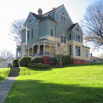
Before the railroads arrived in the Puget Sound region, Port Gamble’s white population consisted primarily of natives from Maine, other parts of New England, and Britain. However, during the 1880s and 1890s the company hired a growing number of non-British European immigrants, including Scandinavians, Germans, Swiss, Slovaks, and Greeks. Beginning in 1890, the company built cottages to house these and other workers in a new district on the other side of the second-growth forest to the west and south of the original plat, and more elaborate dwellings were built in the older residential district. This had the effect of grouping families along socio-economic lines in a pattern seen in many company towns. This second phase of development was formalized by a new plat in 1892. The two neighborhoods remained distinct, and can be readily identified today due to their physical separation and the differences in their housing stock.
Early in the twentieth century, the company freed space for the mill’s expansion by relocating the commercial district to the top of the bluff where it could still be easily seen from the wharves below. Its new location at the north end of Rainier Avenue allowed it to visually dominate the mill site and the community in typical company-town fashion. Buildings completed in this period include the Community Hall (1906), a large General Store (1916), the Puget Hotel (1903, destroyed), and the Puget Hotel Annex (1907, destroyed). The hotel’s stable, built in 1906–1907, remains.
The mill was closed for six to eight months in 1909 as the region struggled to recover from the nationwide financial panic of 1907. In 1925, the Charles R. McCormick Company of Delaware acquired the Puget Mill Company, and in 1926 the mill and docks were rebuilt, increasing production capacity. However, within a few years both the supply of timber and the demand for milled lumber were decreasing. The McCormick Company failed in 1935, and in April 1938, the Pope and Talbot Lumber Company was incorporated to take over the former McCormick properties. In 1940 the firm was again reorganized under the name of Pope and Talbot, Inc. In December 1985, Pope and Talbot, Inc. was reorganized a third time. Major properties were transferred to another entity, Pope Resources, Inc., which took over the Port Gamble mill and town site as well as 78,000 acres of timber and a resort and residential development at nearby Port Ludlow. In 1985, both the town and the mill were leased back to Pope and Talbot, Inc.
After 142 years of nearly continuous operation, the mill was closed on November 30, 1995. It was dismantled the following year and the wharves removed. After closing, the mill site was used for log sorting, chipping, materials handling, and as a marine research facility. In July 2015, work began on a cleanup project to remove pollutants from wood waste and creosote pilings that were released into the bay during the nearly 150 years of the mill’s operation.
When the mill closed, Pope and Talbot’s lease on the town expired. Pope Resources, Inc., assumed responsibility for maintaining the property, including its buildings, common areas, and the cemetery. It continues to manage the property through its subsidiaries: Olympic Property Group and Olympic Resource Management. The commercial buildings and houses are leased, so that the town is once again filled with residents and thriving businesses. By the early twenty-first century, Port Gamble had become a tourist attraction and a popular destination for special events, particularly weddings.
Most of Port Gamble’s commercial and institutional buildings express the commercial vernacular typical of early-twentieth-century buildings around the Puget Sound. The earliest extant non-residential structure is Franklin Lodge #5 (the Masonic Hall), built in 1871–1872 on Rainier Avenue near where the general store now stands; it was moved across the street in 1907 and remodeled to suit its new site. St. Paul’s Church was built shortly afterward, in 1879, possibly from standard plans for Protestant churches. The large Pope and Talbot Office and General Store building (the fifth incarnation of the store) was built in 1916 with a two-part facade typical of large stores of the period. The Automotive Repair and Service Station (c. 1920) was the last new structure to be built by the company at Port Gamble. The mill company hired two of the region’s most prominent architectural firms to design the most important structures. The Puget Hotel was designed by Boone and Corner. The Community Hall and the Puget Hotel Annex were both designed by Bebb and Mendel.
Although the housing typologies found in Port Gamble were common throughout the United States with the expansion of the railroads between 1850 and 1890, they appeared well before the arrival of the railroads in western Washington—possibly because water transportation allowed easy access to waterfront mills and milled lumber was therefore readily available. This made for the rapid diffusion of the associated typologies into the region. Even after transcontinental railroads began to serve the area in the 1880s, Port Gamble relied primarily upon its well-developed waterborne transportation system but remained isolated from the rapid growth that physically impacted other Puget Sound communities.
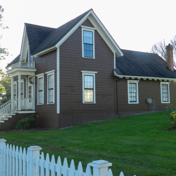
Among the oldest remaining collections of houses in Port Gamble are several structures erected by employees with the company’s support. These include examples of the gable-front house, such the M.S. Drew House and the Captain D.B. Jackson House, and the gable-front-and-wing house, such as the Captain William Gove House—all built between 1870 and 1873. These two typologies developed from New England folk housing traditions, and the frequency of their occurrence at Port Gamble has led many writers to characterize the town as a transplanted New England village. The vernacular housing also includes the town’s earliest extant residence, the James A. Thompson House (1859), an I-house structure based on a typology from the Midwest. There are also side-gabled and pyramidal massed-plan structures; the New York House is an example of the latter.
Later residences include examples of late Victorian–era architecture, such as the Shingle Style Walker-Ames house (1888–1889) and several houses on the west side of town that incorporate the hipped-roof-with-cross-gables roof configuration usually associated with the Queen Anne Style. Popular housing types that emerged in the early twentieth century, such as the bungalow and four-square house, are also in evidence. Many of these are among the two dozen houses barged from another mill town, Port Ludlow, in the 1920s and 1930s.
Modern growth has scarcely intruded upon Port Gamble or the extensive undeveloped lands that surrounds it. Although State Highway 104, a moderately traveled two-lane road, now bisects the community, for the most part, the existing town reflects the plats of 1858 and 1892. Eighty-three of the eighty-five remaining structures stand on their historic sites. The exceptions are the Masonic Lodge, moved to its current site in 1907, and the fire station (now a retail space), moved to its present location in 1976.
The town’s buildings appear much as they have for decades except that many are painted livelier colors, shutters have been added to some of the houses, and several structures exhibit non-historic signage. Lots where buildings were removed remain vacant, and there is no modern infill construction. The Columbus Day Storm of 1962 damaged the Puget Hotel beyond repair and the structure was demolished. The dismantling of the mill in 1996 and the removal of the community school and numerous dwellings since the mid-1950s are significant losses, but the number and variety of surviving architectural resources provide a clear picture of the town’s historic plan and how it evolved and functioned.
References
Eakins, Jan M., “Pope and Talbot Mill Site,” Kitsap County, Washington. Historic American Engineering Record, 1997. Prints and Photographs Division, Library of Congress (HAER No. WA-136).
Eells, Reverend Myron. History of the Congregational Association of Oregon and Washington Territory. Portland, OR: Publishing House of Himes the Printer, 1881.
Gervais, Leon. History of Franklin Lodge No. 5. Poulsbo, WA: unknown, c. 1974.
McKithan, Cecil N., “Port Gamble Historic District,” Kitsap County, Washington. National Register of Historic Places Inventory-Nomination Form, 1977. National Park Service, U.S. Department of the Interior, Washington, D.C.
Ochsner, Jeffrey Karl, ed. Shaping Seattle Architecture: A Historical Guide to the Architects.Seattle: University of Washington Press, 1994.
“Project Information” and “History.” Port Gamble Bay Cleanup Project. Accessed July 17, 2017. www.portgamblebaycleanup.com.
“Walking Tour of Historic Port Gamble: A National Historic Landmark Since 1966.” Port Gamble, Washington: Olympic Property Group, n. d.
Wilma, David. “Port Gamble – Thumbnail History.” Essay 5505. HistoryLink.org: The Free Online Encyclopedia of Washington State History, August 7, 2003. Accessed January 5, 2016. www.historylink.org.
Wilma, David. “Port Gamble Tour.” Essay 7025. HistoryLink.org: The Free Online Encyclopedia of Washington State History, July 29, 2004. Accessed January 5, 2016. www.historylink.org.


