


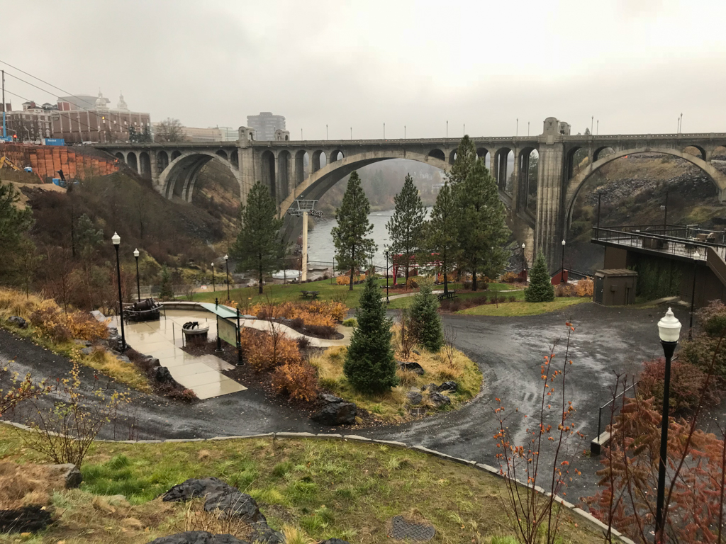
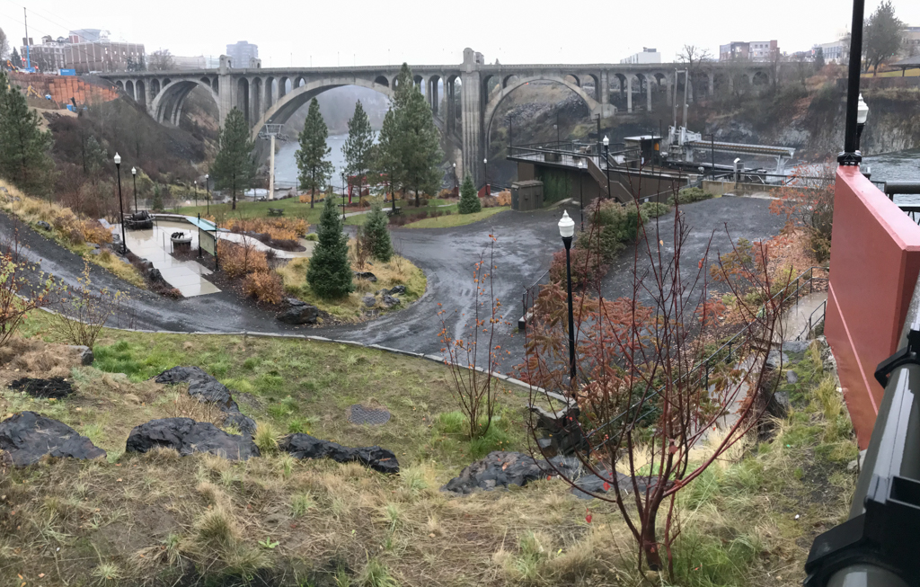


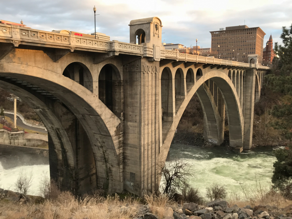
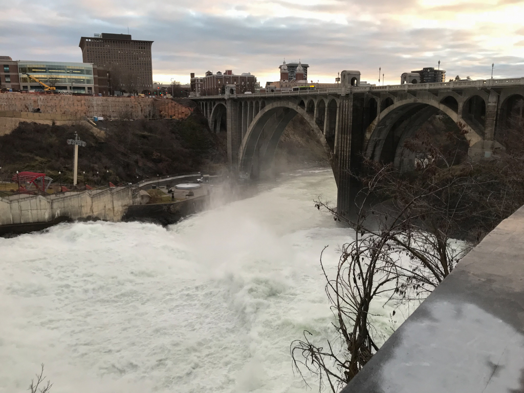


Perched high above Spokane Falls, the massive, two-ribbed, multiple concrete arch Monroe Street Bridge signals Spokane’s growth during the early twentieth century and remains one of the city’s most recognizable landmarks. Although it carries motorized traffic across the Spokane River, the bridge also represents the city’s ongoing transition from its industrial roots to its environmental present. Today, the bridge provides an excellent vantage point from which to view the impressive—albeit altered—Spokane Falls, and to otherwise encounter the “natural” environment in the midst of the largest city of the inland Pacific Northwest.
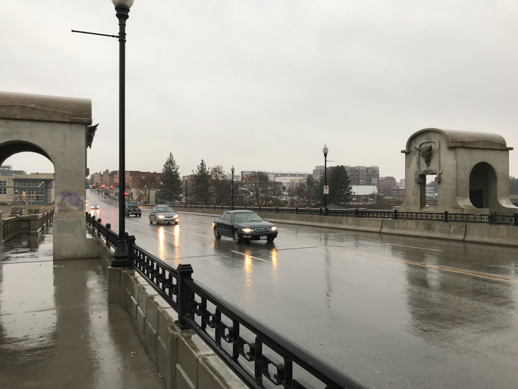
The Monroe Street Bridge, when completed in 1911, was the largest concrete arch bridge in the United States, and the third largest in the world. It was designed by Spokane city engineers with a double streetcar track, and its superstructure features architectural details by the firm of Kirtland Cutter and Karl Malmgren. The 784-foot bridge substructure was constructed with a 281-foot long, 71-foot wide, and 136-foot-high central arch flanked by two 120-foot-long arches. It was the third of three bridges to span the Spokane River at this crucial downtown location connecting north and south Spokane, and it was an engineering and industrial achievement.
The first span was a wooden bridge built by the Spokane Cable Railway in 1889, although it lasted only one year before catching fire in 1890. A steel bridge, complete with overhead wires for streetcars and pedestrian lighting, was quickly erected as a replacement. Noted in part for its visit by actress Sarah Bernhardt, the steel bridge was notorious for its frequent vibrations and was declared unsafe by the National Good Roads Association in 1905. Following the successful completion of the nearby concrete ribbed-arch Washington Street Bridge in 1908 (now demolished), Spokane city engineers planned a concrete replacement for the ailing steel bridge at Monroe Street.
Construction of a new Monroe Street Bridge began in 1909 and its grand opening was celebrated on November 23, 1911 at a ceremony attended by over 3,000 residents. Although cables and steel from the older bridge were reused in the new bridge, concrete was the predominant material. Engineer John Chester Ralston was the lead designer for the bridge, and he was assisted by Morton McCarthy, J.F. Greene, and P.F. Kennedy. This group worked together to design the 1,100-foot-long Latah Creek Bridge on Sunset Avenue in Spokane, and McCarthy later designed the ill-fated Tacoma-Narrows Bridge that collapsed in 1940.
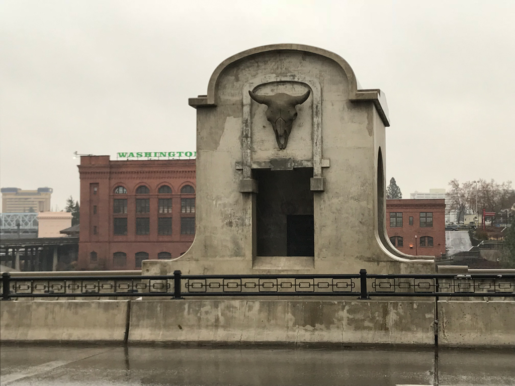
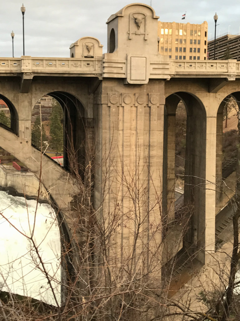
Cutter and Malmgren designed the superstructure, including the ornamentation on the pedestrian walkway and guardrails. The firm ornamented the bridge with eight lifesize bas-relief concrete bison skulls modeled from real bison skulls, two on each pedestrian overlook. These were intended to symbolize the power of the bridge and the earlier “Wild West” history of the Spokane area prior to European-American settlement. The architects also designed a chain motif on the guardrail to symbolize Spokane’s industrial might and to offer pedestrians a feeling of continuity as they traversed the bridge.
Four pedestrian overlooks were included as part of the original roadway design, providing views of Spokane Falls and of the Cutter-designed Washington Water Power Building (1909), which generated its power from the falls. Pedestrians could simultaneously admire the dramatic natural drama of the falls and the public works that were busy transforming the raw force of the water into electricity for the growing city. Shortly after the bridge’s completion, however the Union Pacific Railroad erected a steel viaduct diagonally above its north end in 1914, disturbing its otherwise pristine appearance. Despite the views to the falls and Cutter and Malmgren’s bison heads suggesting a picturesque view of the West, the Monroe Street Bridge instead presented a mostly industrial guise in its early years.
Aside from periodic roadwork and the removal of the electric streetcar infrastructure in 1934 to create four lanes of traffic, the bridge, together with the Union Pacific Railroad steel viaduct, remained mostly unaltered for 62 years. In 1973, however, the viaduct was removed in preparation for Spokane’s world’s fair; its removal was part of a larger civic environmental agenda concomitant with the clearance of an island in the Spokane River previously dominated by railroad tracks, warehouses, and machine shops. Following this project, the overlooks provided by Cutter and Malmgren could once again direct viewers to those elements suggesting Spokane’s renewed focus on the natural environment; namely, to the falls and Riverfront Park—the latter created on the island following the exposition. In 1976, the bridge was added to the National Register of Historic Places.
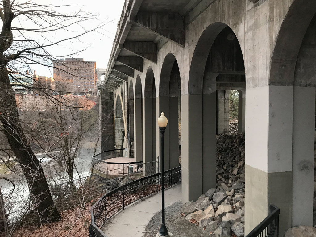
Yet by the 1990s the Monroe Street Bridge was suffering from extensive roadway deterioration, and in January 2003 it was closed while Spokane city officials debated whether it would be restored or replaced. The city opted for an $18 million restoration plan and chose David Evans and Associates to reconstruct the bridge superstructure. Cast-in-place concrete construction was used to maintain the original design and appearance, while the deck structure, spandrel arches, columns of the three principal arch spans, and the existing arch ribs were replaced. The original four pedestrian overlooks and bison heads were recreated based upon digital renderings, and concrete casts were created to replicate the original bison head forms. The construction lasted nearly three years and the bridge reopened to the public in September 2005.
From its earliest years, the Monroe Street Bridge has been featured on postcards and other materials promoting the city of Spokane, even when the bridge presented a more “industrial” appearance. The removal of the railroad viaduct in preparation for Expo ’74, however, began a transformation of the bridge’s—and the city’s—symbolism from an industrial focus to that of the natural environment. While the bridge continues to serve as a transportation link between downtown and North Spokane, it remains an iconic Spokane attraction for its graceful, concrete arches and its dramatic setting above the Spokane River with its views to the Spokane Falls and downtown Spokane.
References
Arksey, Laura. “Spokane’s Third Monroe Street Bridge, the Historic Concrete-Arch Bridge, Opens on November 23, 1911.” HistoryLink.org: The Free Online Encyclopedia of Washington State History, March 2, 2006. Accessed July 3, 2017. www.historylink.org.
Garrett, Patsey M., “Monroe Street Bridge,” Spokane County, Washington. National Register of Historic Places Inventory–Nomination Form, 1975. National Park Service, U.S. Department of the Interior, Washington, D.C.
Matthews, Henry C. Kirtland Cutter: Architect in the Land of Promise. Seattle: University of Washington Press: 1998.
Holstine, Craig, and Richard Hobbs. Spanning Washington: Historic Highway Bridges of the Evergreen State.Pullman: Washington State University Press, 2015.