


With the success of the Erie Canal in New York, other states began looking at canal construction as a way to develop much needed transportation routes. The Chesapeake and Ohio Canal (C&O) was one such early-nineteenth-century canal planned to connect Washington, D.C., with Pittsburgh, Pennsylvania. Although not fully realized, the 184.5-mile canal extended from Georgetown, Washington, D.C., to Cumberland, Maryland, paralleling the Potomac River. The C&O Canal remains a testament to early American engineering and its towpath and right of way are still in use as a recreational corridor managed by the National Park Service.
The Potomac River Valley had been identified in the late eighteenth century as a viable transportation corridor. George Washington envisioned a canal as a way to transform the District of Columbia into a major commercial center. Although the Potomac Canal Company, chartered in 1784 and first led by Washington, made some navigational improvements, like a bypass canal around Great Falls, Maryland, work ceased by 1816. Renewed interest in developing a canal along the Potomac led to formal establishment of the Chesapeake and Ohio Canal Company in June 1828, with construction beginning the following month. The company hired a number of men who had gained experience in canal design and construction through their work on the Erie Canal, including James Geddes, Nathan Roberts, Benjamin Wright, and John Martineau. Other engineers who contributed to the canal design were Charles Ellet Jr., Thomas F. Purcell, Alfred Cruger, and Charles Fisk. The project was divided into sections contracted to various companies. Difficulties in obtaining rights-of-way, litigation, and labor shortages, as well as the difficult terrain in the western part of the canal route slowed work, but by 1839, 134 miles had been completed. Financial difficulties stopped work until 1846 when the last 50-mile section was started, which included the Paw Paw Tunnel, a 3,118-foot engineering feat. The canal officially opened on October 10, 1850, but by then it had already been superseded by the Baltimore and Ohio Railroad (B&O). Nevertheless, the canal was profitable for brief periods in the nineteenth century as it was used to transport goods, lime, stone, and coal from western Maryland to Washington, D.C.
Flooding in 1889 almost caused the canal company to cease operations as it lacked the necessary funds to repair the significant damage. The B&O Railroad, as mortgage holder, financed the repair work to keep its competitor, the Western Maryland Railroad, from purchasing the canal. A 1924 flood again caused severe damage; the Canal Towage Company, which then operated the canal, repaired the lower end where power was produced, but the rest of the route was abandoned. In 1938, the U.S. Government purchased the canal from the B&O for $2 million. The Chesapeake and Ohio Canal National Historical Park was established in 1971, and the canal was listed in the National Register in 1979.
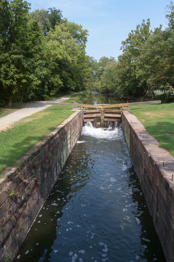
The C&O Canal consisted of the canal prism with a berm on one side to provide a stable slope and a towpath on the other for the horse or mule to pull the boat along the canal. To overcome the 610-foot difference in elevation between Georgetown and Cumberland, seventy-four lift locks were needed to raise or lower boats. On the C&O Canal, the locks typically had masonry chambers, except for the later ones that were composite, and wooden miter gates. The locks were generally 100 feet long, 15 feet wide, and 16 feet deep, with lifts ranging from six to ten feet. Four generations of locks have been identified along the canal. The first design, dating to 1828, can be seen in locks 1-27, where the upper miter gates were located in the breast wall outside the lock chamber. These locks used culverts fitted with wickets to water the chamber.
The second generation dates from 1830 when the design was modified so that the upper miter gates were located within the lock chamber. Because of problems with debris clogging the culverts in the 1828 design, the wickets were part of the gate. The third generation of locks (numbered 58-71) was built along a 26-mile stretch from Fifteen Mile Creek to Oldtown following a plan by Ellwood Morris, Principal Assistant Engineer. His plan for composite locks was based on the locks built along the Chenango Canal in New York State; the locks used rubble for the chamber walls (for economical reasons and because of a lack of viable stone in the area) and were faced with timber to protect boats from damage. Finally, from 1876–1883, company president Arthur Poe Gorman decided that the canal’s locks needed to be enlarged to make the company competitive. Although he wanted all seventy-four locks extended by 10 feet, only locks 25 through 32 were actually altered.
Specifications were developed for the various structures required along the canal route, which resulted in a unified style characterized by the use of masonry arches (generally Seneca red sandstone in the vicinity of locks 8-27 and limestone and granite elsewhere). In addition, the lockhouses in which the lock tenders and their families resided followed a general design plan developed by John Martineau and based on those built along the Erie Canal. The simple lockhouses were 18 x 30-foot, one-and-one-half-story structures with basements. They were initially built of stone, but amended specifications in 1836 allowed for the use of brick.
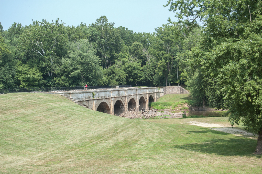
Eleven aqueducts were required to carry the canal over major creeks supplying the Potomac River. In keeping with the rest of the canal, these were masonry arch structures. In addition, 200 culverts were built along the route for directing water from creeks and streams under the canal, as well as for roads. The culverts were also generally masonry arch structures.
To compensate for variations in water level throughout the canal, seven diversion dams were constructed to impound water, which was then fed into the main canal prism through feeder canals equipped with guard locks. Three river locks were also built to allow boats to enter the canal at various points along the route: Goose Creek, Shenandoah River, and Shepherdstown. In addition, three streams were used as feeders: Rocky Run, Great Falls, and Tuscarora. In spite of its rapid obsolescence with the rise of railroad transportation, the Chesapeake and Ohio Canal was a highly significant engineering accomplishment of first half of the nineteenth century.
References
Kapsch, Robert J. Canals. New York: W. W. Norton & Company, 2004.
Kyrtle, Elizabeth. Home on the Canal. Baltimore: Johns Hopkins University Press, 1996.
Maddex, Lee R. “Chesapeake & Ohio Canal, Conococheague Aqueduct.” HAER No. MD-123, Historic American Engineering Record, 1996. Prints and Photographs Division, Library of Congress, Washington, D.C.
Unrau, Harlan D. Historic Structure Report, The Lockhouses, Historical Data. Denver, CO: Denver Service Center, Historic Preservation Team, National Park Service, U.S. Department of the Interior, May 1978.
Unrau, Harlan D. Historic Resource Study: Chesapeake & Ohio Canal. Prepared by Karen M. Gray. U.S. Department of Interior, National Park Service, Chesapeake & Ohio Canal National Historical Park, Hagerstown, Maryland, August 2007.