


One of the nation’s largest institutions of higher education, the University of Minnesota, Twin Cities comprises essentially three campuses: two in Minneapolis (an East Bank and a West Bank, each straddling the Mississippi River) and a predominantly agricultural campus approximately two miles away in St. Paul. The mostly urban land-grant university includes two historic districts on its East Bank, yet retains a general sense of openness—not only at the St. Paul campus, adjacent to the state fairgrounds, but on its East Bank campus with the broad, central Northrup Mall and its views to, and over, the Mississippi River. As with nearly all land-grant institutions established following the original Morrill Act of 1862, however, the University of Minnesota was also the recipient of formerly Indigenous land. In fact, nearly 95,000 acres of land forcibly ceded in 1851 by the Dakota—a substantial slice of the single-biggest Indigenous land cession, portions of which ultimately secured endowments for some thirty-five land-grant colleges—was used to establish the land upon which the campus sits.
The University of Minnesota, Twin Cities was technically established that same year, in 1851, as a preparatory school along the Mississippi River in the vicinity of St. Anthony Falls approximately one mile north of the current East Bank site. The school would move to the East Bank in 1857, but it closed in 1859 due to financial difficulties. In 1868, however, Minneapolis business leader (and later University of Minnesota regent and governor) John Sargent Pillsbury persuaded the state legislature to pass the University Reorganization Act. This ensured that the University of Minnesota would be the beneficiary of the money set aside from the Morrill Act—provided it would facilitate teaching and research in agriculture, mechanic arts, and military science, along with arts and sciences.
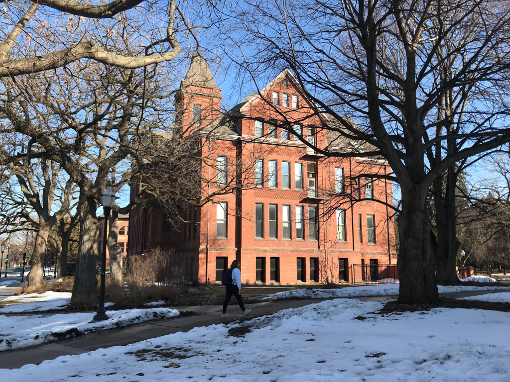
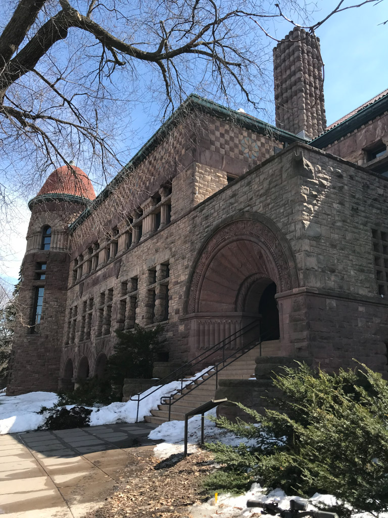
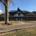
The first building for the new land-grant college was Old Main, completed in 1875 but destroyed by fire in 1904. By the early twentieth century, however, the campus built environment had taken shape under the tenure of President Cyrus Northrup (1884–1911) on and around the “Knoll,” a sloping landscaping between 14th and 15th avenues and south of University Avenue. An eclectic set of thirteen surviving buildings from a nearly twenty-year period spanning the turn of the last century today comprises the Old Campus historic district. Most of those buildings, several of which involved the work of architect LeRoy S. Buffington, featured the revival fashions of the day: the Richardsonian Romanesque Pillsbury Hall, the Renaissance Revival Wulling Hall, the Greek Revival Burton Hall, and the Jacobethan Revival Folwell Hall. The Queen Anne Eddy Hall was erected as the Mechanic Arts Building in 1886 and was the first home for engineering—part of the original land-grant mission and the oldest surviving building on today’s campus.
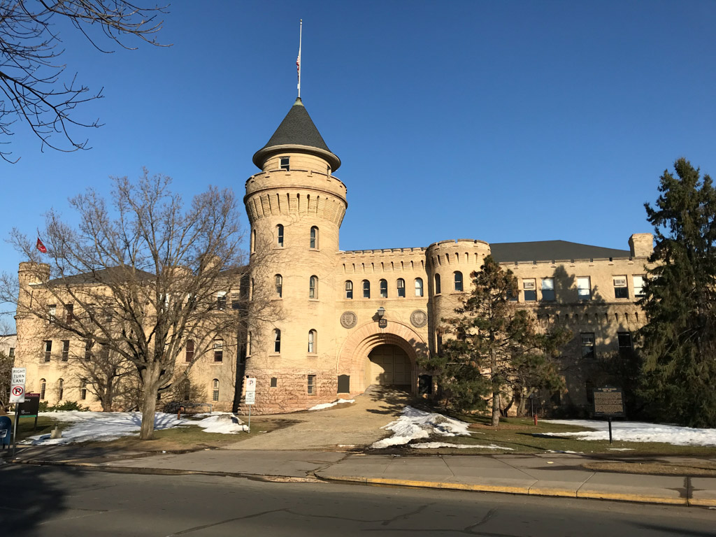
Perhaps the most imposing physical reminder of the university’s land-grant mission is the Armory (1896, Charles R. Aldrich), which stands today near the northern entrance to campus. Built to provide training in military tactics and to replace the massive Coliseum following its 1894 fire, the Normal Revival structure, with its alternating patterns of yellow brick, crenellations, Lombard bands, turrets, and conical turret, seems rather incongruous with the modern-day, cosmopolitan research institution. Yet training in military tactics was mandated in the original Morrill Act and the building blended with the eclectic architecture of campus in the late nineteenth and early twentieth centuries.
The Knoll itself found some definition under H.W.S. Cleveland’s 1892 plan for the university. Within that project, Cleveland suggested the Knoll might follow the principles of the picturesque, with winding pathways and trees spaced at irregular intervals. Such principles continued into the twentieth century, when Warren H. Manning’s 1905 plan, the “Traverse Survey of a Portion of Campus Along River Bank,” included a new road to bend with the curve of the Mississippi River. Together, the Cleveland and Manning plans provided a refined landscape for the University of Minnesota campus that distinguished it from the urban environment of Minneapolis.
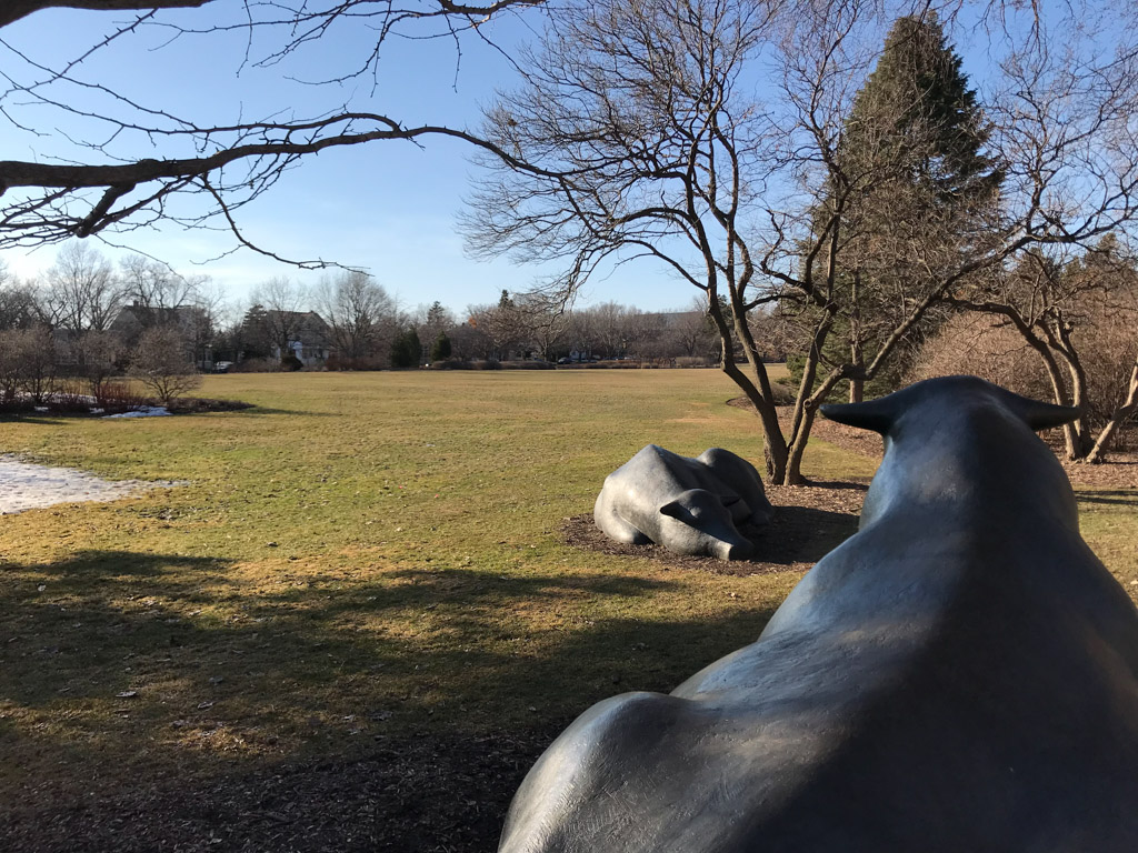
There was less apparent need to hire landscape architects to ameliorate the presumably less civilizing effects of urbanization on the St. Paul campus—at least not at first. The area where the campus would be constructed was already rural in 1862 when the university purchased what was the 155-acre Bass Farm in St. Anthony Park for the purposes of agricultural instruction and research. Originally called the University Farm, the St. Paul campus followed the passage of the 1887 Hatch Act and the granting of $15,000 for the university to conduct agricultural experiments, to which it later added instruction in forestry, home economics, and agricultural extension. The site, however, was not left unkempt. Campus horticulturist Samuel B. Green helped shape the landscape and its agricultural plots in the late nineteenth century, and by 1917, the St. Paul campus featured over thirty buildings. A 1930s master plan by Morell and Nichols, a landscape architecture firm already working on the East Bank campus, provided some definition to an existing meadow that would later become the “Lawn.”
Facing west along Eckles Avenue toward the Lawn today are three red brick and sandstone classical buildings built in the early 1920s: Coffey Hall (Administration), the Biosystems and Agricultural Engineering Building, and Haecker Hall (the Dairy Building). These buildings, together with the original McNeal Hall (Home Economics) to the north, created a stately, more formal physical visage for the agricultural college on its “beautifully wooded and rolling campus.” During the twentieth century, the university added the College of Veterinary Science (1947) and the College of Biological Sciences (1965). Consolidation of existing departments created the College of Food, Agriculture, and Natural Resource Sciences; the College of Education and Human Development; and the College of Design in 2006.
The university’s prevailing image at the turn of the twentieth century was not the St. Paul campus, however. Instead, it remained the collection of buildings scattered loosely about the Knoll on the East Bank—a suitable arrangement for a built environment seemingly close to the natural environment, but one deemed unworthy of the proper institutional gravitas for a major university. In 1907, the Board of Regents held a $1,000 competition for a new campus plan, won by nationally prominent architect Cass Gilbert. The plan envisioned a monumental, Beaux-Arts layout to the south of the Knoll, featuring a mall, oriented north and south, punctuated by a domed structure in the fashion of Daniel Burnham’s plan for the World’s Columbian Exposition and his subsequent plans for the cities of San Francisco, Cleveland, and Chicago (Burnham was a member of the board to select the winner of the competition). The drawings Gilbert provided extended the more than 1,000-foot-long and 275-foot-wide mall southward to the Mississippi River with a central plaza punctuated by a campanile, amphitheaters, diagonal pathways, terraces, and parterres and included provisions for a medical complex beyond the central axis. Gilbert’s plan formally resembled McKim, Mead and White’s Beaux-Arts plan for Columbia University yet was more ideologically linked to Thomas Jefferson’s U-shaped academical village at the University of Virginia, with its rotunda and classical pavilions facing an open expanse of wilderness. Yet the scale of Gilbert’s plan was vaster than either of them, and the planned buildings were larger.
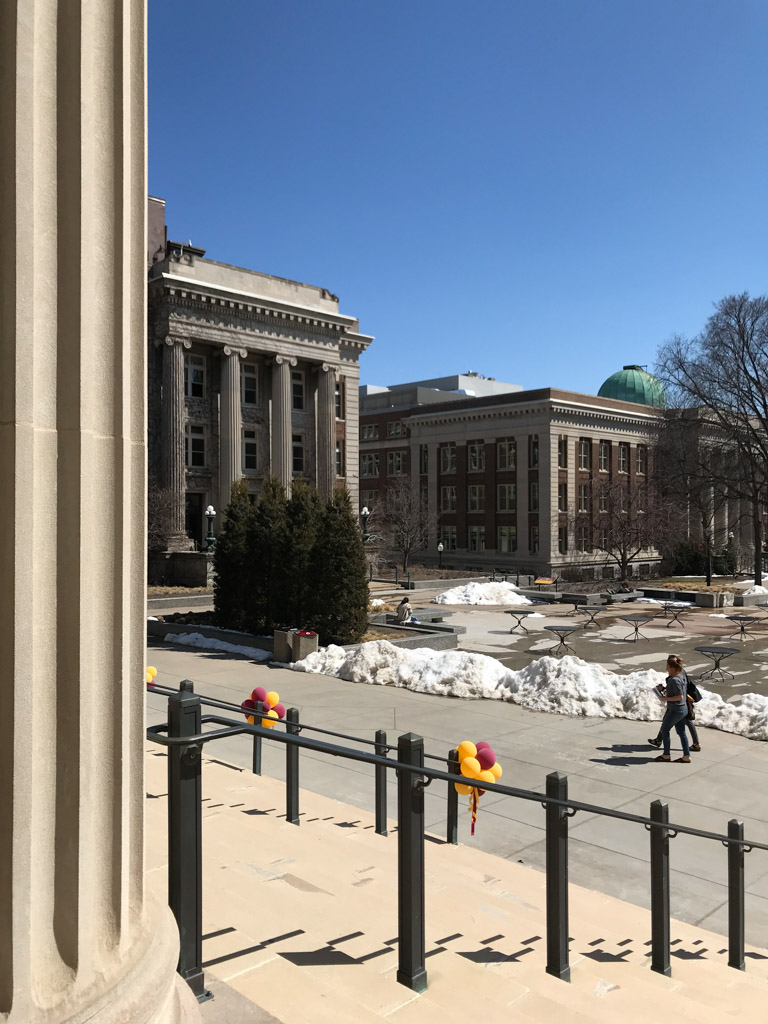
Gilbert’s drawings were long on romance and short on details, but they provided for this rising Midwestern land-grant institution something on the grandeur of Haussmann’s Paris. One rendering entered as part of the competition, for example, depicted figures strolling along a grand promenade with carriages and a single automobile, flanked by varied—yet ordered—three-to-four-story classical buildings on what appears to be a crisp early evening in late fall. Though Gilbert sought to preserve the existing Washington Avenue, which cut east-west through the southern portion of the East Bank campus and extended along a bridge leading to downtown Minneapolis, he eliminated a tangle of railroad tracks and existing agricultural research buildings. As with most grand plans at state-funded land-grant institutions, however, a variety of factors intervened to prevent its full completion. Yet subsequent years saw the development of the principal characteristics of Gilbert’s plan, including the main mall and the medical complex. Clarence H. Johnston was the architect responsible for the design of the principal buildings along what is now called the Northrop Mall.
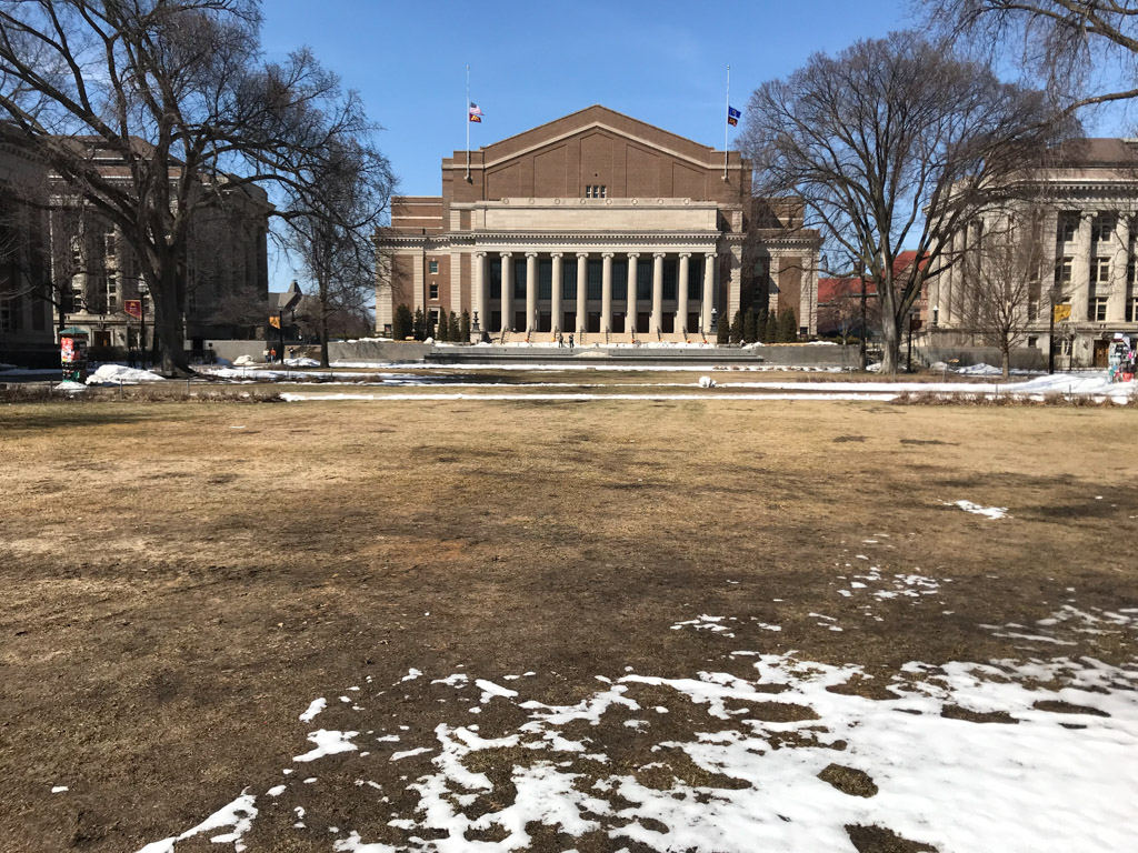
Most prominent of Johnston’s designs was that for the Cyrus Northrop Memorial Auditorium, completed in 1929. The five-story building at the head of the mall, with its massive brick pediment above an Ionic portico, fronts a 4,847-seat auditorium that served as the main performance space for the entire Twin Cities region for much of the twentieth century. An inscription on the building’s entablature announces the university’s aim to devote itself to instruction of the youth and “the welfare of the state”: a welfare that emerged along the Northrop Mall with a series of classical buildings completed between 1913 and 1940. Morrill Hall, built to house the university administration, is perhaps the most purely classical among them; completed in 1925, its facade bears a loose resemblance to the Temple of Athena Nike on the Athenian Acropolis—though executed in brick and limestone, not marble. Other buildings lining the mall combine classical stone porticos against mostly red brick facades; Smith Hall (1913) was the first to be completed, but of these, the most elaborate interior is that of the Walter Library (1923) with its Mankato limestone-clad vestibule, staircases, and reading room with octagonal coffers. These and other buildings were listed as part of a Northrop Mall Historic District in 2018.
Several other buildings erected following Gilbert’s plan expanded the campus beyond the mall: most notably a series of red brick, streamlined buildings for the medical campus (courses in medicine began on the East Bank in 1893) and new, low-lying dormitories with vaguely Colonial Revival features. All of these buildings were emerging to the southeast in a more grid-like pattern. The Streamlined Moderne Coffman Memorial Union, designed by Clarence H. Johnston, Jr. in 1940, was erected where Gilbert’s plan had called for an open plaza, terminating the Northrop Mall axis and blocking the view to the river.
Gilbert’s plan was symbolically scaled to the university’s future growth, though considerable development of campus had yet to happen. As with other public institutions around the country, enrollment skyrocketed in the post–World War II years, and new federal monies for research—particularly in the sciences and engineering—accompanied that growth. The expansion was characterized architecturally by the large, minimally ornamented buildings on the East Bank, including the fourteen-story Mayo Memorial Building (1954, Clarence H. Johnston, Jr.) and the seventeen-story, 268-foot concrete aggregate Malcom Moos Health Sciences Tower and adjoining Phillips-Wangensteen Building in the medical complex. Closer to the mall, the attachment of Murphy Hall to the rear of mall-facing Vincent Hall and its striking landscaped courtyard by Roger Martin was completed in 1968. Deeply and literally connected to the university’s land-grant mission and its connection to mining, the Civil Engineering Building, designed by BRW Architects and completed in 1982, is embedded 110 feet—seven stories—into the earth.
The post–World War II years at the University of Minnesota, Twin Cities were also visibly marked by the automobile. Beyond the emergence of multi-level parking structures around campus, the prevalence of cars on the roads surrounding the university spurred the conversion of Washington Avenue, which already bisected the East Bank, into a high-speed feeder road for the Washington Avenue Bridge and nearby interstate highways. This made for increasingly hazardous conditions for anyone attempting to cross between the northern and southern parts of the East Bank campus. Considerable architectural development, meanwhile, occurred across the river on the new West Bank campus—land for which the university began purchasing in the 1950s. By the 1960s, the West Bank included several facilities expanding the medical school and new, dedicated space for the Hubert H. Humphrey School of Public Affairs, the Carlson School of Management, and the University of Minnesota Law School. The Middlebrook Hall dormitory (1967, Griswold and Rauma) remains one of the more architecturally notable, or at least visible, buildings on that campus.
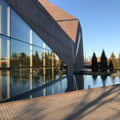
The late-twentieth-century architectural splash brought Frank Gehry to campus for the design of the Frederick R. Weisman Art Museum. Situated atop a bluff overlooking the Mississippi River and completed in 1993 (with an addition in 2011, also by Gehry), the building’s curved, river-facing, brushed stainless steel panels offered a thoroughly different image for the university—even if the mostly brick south and east facades were intended to blend with the existing campus fabric. Hiring well-known architects became more popular after Gehry’s museum was finished. In 2000, for example, Antoine Predock’s angled glass-and-stone McNamara Alumni Center opened on the site of the former Memorial Stadium at the northeastern edge of the East Bank campus. An addition to the alumni center, also designed by Predock, opened nine years later and coincided with the completion of the new, 50,000-plus capacity TCF Bank Stadium for Minnesota football across Oak Street Southeast to the east. In 2002, Steven Holl’s addition to the 1960 Thorshov and Cerny–designed building for the College of Design opened near the heart of campus.
Not all campus development in the early twenty-first century was focused around signature buildings. The transformation of Washington Avenue Southeast into a transit way for light rail, pedestrian, and bicycle access, for example, facilitated the walkability and safety of the campus when it was completed between 2011 and 2014. Yet the transportation corridor, which cuts in front of the Coffman Memorial Union, still provides something of a jarring incision in the university fabric. Multi-level parking structures and surface lots remain a dominant element of both the East and West banks of campus.
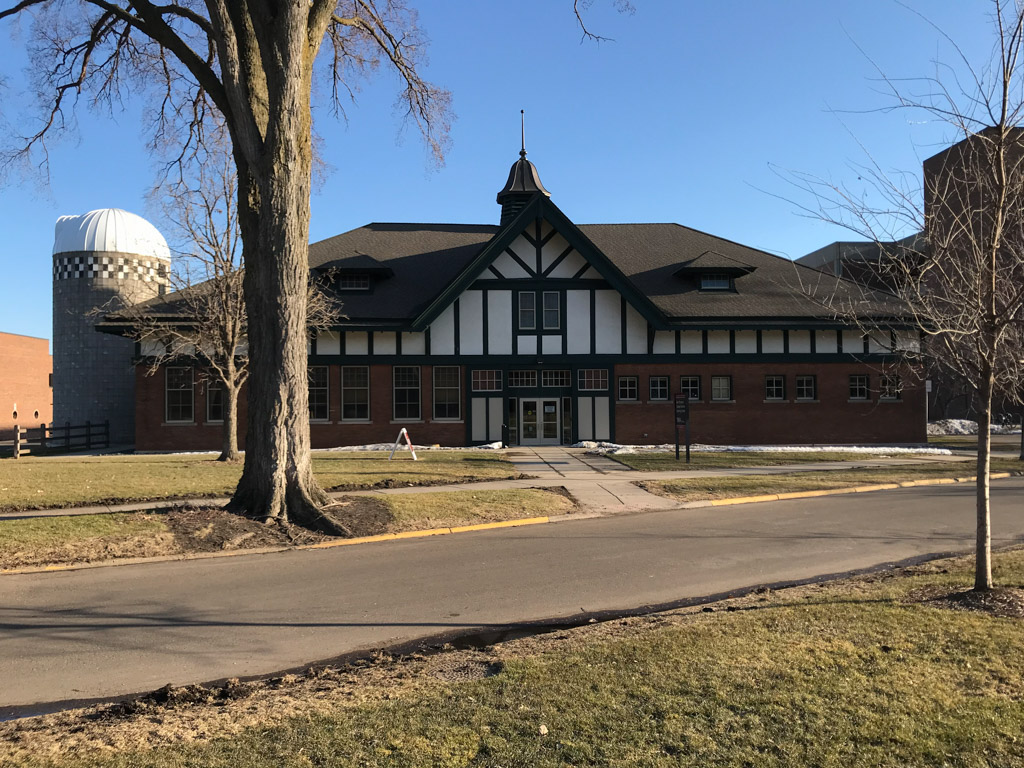
Development pressures have been less significant on the St. Paul campus, which has retained a rural, almost pastoral appearance despite the encroachment of Falcon Heights around it. Yet there has been some new construction since the early twentieth century, including a student center and a three-story addition with an open atrium to McNeil Hall for the College of Design (1975, Hodne Stageberg Partners). Perhaps better connected to the roots of the University Farm, however, was Miller Dunwoodie Architects’ conversion of a 1907 dairy cattle barn into a technology and alumni center for the College of Veterinary Medicine in 2007. The architects maintained the loosely Tudor Revival shell of the older barn while retaining the attached feed silo in a more environmentally-friendly building known today as the Ben Pomeroy Student-Alumni Learning Center. The exterior of the building does not immediately project an image of the high-tech, high-powered, twenty-first-century campus that the University of Minnesota, Twin Cities has become, but a repurposed barn on its agricultural campus is a fitting reminder of its land-grant heritage.
References
Federal Writers’ Project of the Works Project Administration. Minnesota: A State Guide, 1938. Reprint. The WPA Guide to Minnesota. St. Paul: Minnesota Historical Society, 1985.
Gebhard, David, and Tom Martinson. A Guide to the Architecture of Minnesota. Minneapolis: University of Minnesota Press, 1977.
Gray, James. Open Wide the Door: The Story of the University of Minnesota. New York: G.P. Putnam’s Sons, 1951.
Lee, Robert, and Tristan Ahtone. “Land-Grab Universities: Expropriated Indigenous Land is the Foundation of the Land-Grant University System.” High Country News (Paonia, CO), March 30, 2020.
Nathanson, Iric. “Land-Grant Exhibit Looks Back at 150 Years of U of M History.” MinnPost (Minneapolis, MN), September 10, 2012.
Neckar, Lance M. “Warren H. Manning and His Minnesota Clients: Developing a National Practice in a Landscape of Resources.” In Midwestern Landscape Architecture, ed. William H. Tischler. Urbana: University of Illinois Press, 2000.
Pille, Keith. “Frederick R. Weisman Art Museum,” [Minneapolis, Minnesota], SAH Archipedia, eds. Gabrielle Esperdy and Catherine Boland Erkkila. Charlottesville: University of Virginia Press, 2012–, http://sah-archipedia.org/buildings/MN-01-053-0002. Accessed June 4, 2020.
State Historic Preservation Office Staff. “University of Minnesota Old Campus Historic District.” Hennepin County, Minneapolis. National Register of Historic Places Registration Form, 1984. National Park Service, U.S. Department of the Interior, Washington, D.C.
“University of Minnesota Campus Plan.” Cass Gilbert Society. Accessed June 13, 2019. https://www.cassgilbertsociety.org/.
“University of Minnesota-Twin Cities.” Cultural Landscape Foundation. Accessed June 12, 2019. www.tclf.org.
Weber, Laura. “Cyrus Northrop Memorial Auditorium,” [Minneapolis, Minnesota], SAH Archipedia, eds. Gabrielle Esperdy and Catherine Boland Erkkila. Charlottesville: University of Virginia Press, 2012–, http://sah-archipedia.org/buildings/MN-01-053-0057. Accessed June 4, 2020.