Martin Luther King, Jr. Park
The Parade forms the eastern node of the landscape arc that serves as the spine of Olmsted and Calvert Vaux’s masterplan for Buffalo’s park and parkway system. First designed in 1871 and renamed for Martin Luther King, Jr. in 1977, The Parade sits on the city’s highest ground and was intended originally for military drills. It is distinct in Buffalo’s park system in that it displays two distinct phases of landscape design separated by a quarter century and envisioned by Olmsted and his successors.
The original design of the shallow L-shaped parcel featured a 20-acre parade ground in the west and a densely planted, circular grove in the east that functioned as a children’s playground. A perimeter drive encircled both, and all but the southern boundary of the park was screened from the surrounding neighborhood by planted trees. At the site’s southeastern corner was a gravel carriage concourse marking the entry of the Parade House, designed by Vaux in 1874. The two-story, Stick Style wooden building was largely open-air, like an elongated gazebo. With arcaded loggias from which spectators could watch events on the parade grounds, it also housed a restaurant and ballroom. It was destroyed by fire in 1877 and rebuilt, with a smaller footprint, by local architect Cyrus K. Porter.
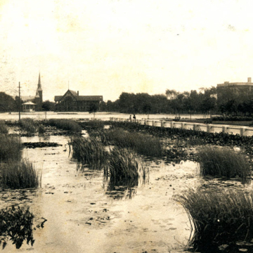
In 1895, with the Parade underutilized as a military training ground, Olmsted, Olmsted and Eliot (the successor firm to Olmsted and Vaux’s partnership) redesigned the 56-acre common. Now devoid of its military function, the Parade became an open space for the surrounding neighborhood thenceforth called Humboldt Park. The northern and southern portions of Fillmore Avenue, which had terminated at the Parade’s boundary, were joined in 1886, thereby dividing the park into east and west sections. The former parade grounds were transformed into a formal, elliptical water garden, in which radial allées led to tripartite water basins: a circular fountain in the west, and in the east a rectangular lily pond and a 500-foot-diameter wading pool. The children’s grove was converted into a densely canopied picnic ground, while thicker plantings of trees were added to the park’s perimeter. Also added at this time were flower gardens, a granite bandstand (1898) designed by Fred Harvey Loverin, and a gymnastics playground; the conservatory designed circa 1895 was not built until 1910. In 1904 Olmsted Brothers further amended the landscape plan, revising the southeastern portion where a small brick shelter was built on the site of Vaux’s Parade House and its replacement. The small shelter was designed by Robert A. Wallace in the manner of a Swiss chalet.
The park was altered in the 1920s without the guidance of the Olmsteds or the Board of Park Commissioners, which was eliminated after revisions to the Buffalo City Charter went into effect in 1916. A large brick casino was built between the lily pond and wading pool in 1926, and the Art Deco Buffalo Museum of Science, designed by Esenwein and Johnson in 1925, was erected just north of the elliptical water gardens. Four tennis courts were built north of the shelter; the bandstand was demolished in 1950; and an ice-skating rink replaced the lily pool in 1956. Basketball courts were later built on the site of the fountain, and the large wading pool was partially filled and turned into a much smaller spray pool. In 1992, a rectangular wading pool was built on the site of the former lily pond and ice-skating rink.
Originally, the Parade was connected to what is now Delaware Park by Humboldt Parkway, but the construction of the intrusive Kensington Expressway circa 1960 severed this connection, leaving the Parade isolated from the larger system.
References
Broderick, Stanton M. “Buffalo’s Olmsted Parks and Parkways System.” Olmsted in Buffalo. Accessed March 16, 2021. https://www.olmstedinbuffalo.com/.
Kowsky, Francis R., ed. The Best Planned City: The Olmsted Legacy in Buffalo. Buffalo: Burchfield Art Center, 1992.
Kowsky, Francis R. “Municipal Parks and City Planning: Frederic Law Olmsted’s Buffalo Park and Parkway System.” Journal of the Society of Architectural Historians 46 (March 1987): 49-64.
Rogers, Elizabeth Barlow. Landscape Design: A Cultural and Architectural History. Harry N. Abrams, Inc., 2001.
Ross, Claire L., “Olmsted Parks and Parkways Thematic Resources,” Erie County, New York. National Register of Historic Places Registration Form, 1982. National Park Service, U.S. Department of the Interior, Washington, D.C.
Writing Credits
If SAH Archipedia has been useful to you, please consider supporting it.
SAH Archipedia tells the story of the United States through its buildings, landscapes, and cities. This freely available resource empowers the public with authoritative knowledge that deepens their understanding and appreciation of the built environment. But the Society of Architectural Historians, which created SAH Archipedia with University of Virginia Press, needs your support to maintain the high-caliber research, writing, photography, cartography, editing, design, and programming that make SAH Archipedia a trusted online resource available to all who value the history of place, heritage tourism, and learning.


