


For more than two centuries, Public Square has been the physical and symbolic center of Cleveland and architectural landmarks line its perimeter. A reflection of the city’s status as a commercial and industrial center, Public Square has played an enduring role in the civic life of the community. During the nineteenth century, the area surrounding the square evolved from a residential neighborhood into a commercial district. By the end of the twentieth century, the three tallest skyscrapers in Cleveland fronted on Public Square.
Public Square has its origins in the Connecticut Land Company’s “Original Plan of the Town and Village of Cleaveland,” prepared in 1796 with surveying overseen by Moses Cleaveland. That plan described a 9.5-acre public square (now commonly referred to as ten acres) bisected by two wide streets, Superior (east-west) and Ontario (north-south), forming four equal-size quadrants. The Square was conceived as the green open space of a traditional New England town plan, intended to serve as a common grazing area and meeting place. During the early nineteenth century a few houses bordered the square, as the city’s fledgling commercial activity focused on the Cuyahoga River to the west and south of Public Square.
As Cleveland’s population grew more quickly with the completion of the Ohio and Erie Canal (1827–1832) and the arrival of railroads in the late 1840s, Public Square became a contested site. Competing community interests resulted in the so-called Fence War, which lasted for some fifteen years. Residents near the square clamored for park space in the expanding city and they advocated for replacing the 1830s scheme, in which each quadrant was fenced separately, with a single fence encircling the perimeter of all four quadrants. Under this “central park” plan Superior and Ontario streets would terminate at the edges of the Square and push all traffic to the perimeter road. Business interests strenuously objected, arguing that the proposed street closings would hinder the area’s commercial development. Though residents petitioned the City Council to consider the “central park” as early as 1852, only in 1857, after five years of discussion, did council finally vote to vacate Superior and Ontario streets. The grounds of Public Square were landscaped and enclosed by a white, double-rail fence. The square quickly became a popular recreation area, but opposition continued, especially from the commercial interests on Superior Street east of the Square. In 1867 the Municipal Court ruled that Superior had been dedicated as a continuous street, and both streets were reopened. The only surviving building from this period is the Romanesque Revival First Presbyterian Church (Old Stone Church), built in 1853–1855 by Heard and Porter.
By the mid-1870s, civic and commercial buildings ringed the Square, as it became a focal point for the city’s commerce and civic life. It had also emerged as a transportation hub, integral to Cleveland’s expanding streetcar network in the last decades of the nineteenth century. Community celebrations and remembrances were held at the Square, along with singular events such as Charles F. Brush’s first successful demonstration of electric streetlights on April 29, 1879. Burnham and Root’s Society for Savings Bank (1889–1890), a robust, medieval-inspired, ten-story structure clad in red sandstone, is a significant building from this period, which also saw the construction of the imposing Civil War memorial, the Soldiers’ and Sailors’ Monument (1894, Levi Scofield) occupying the southeast quadrant of the Square.
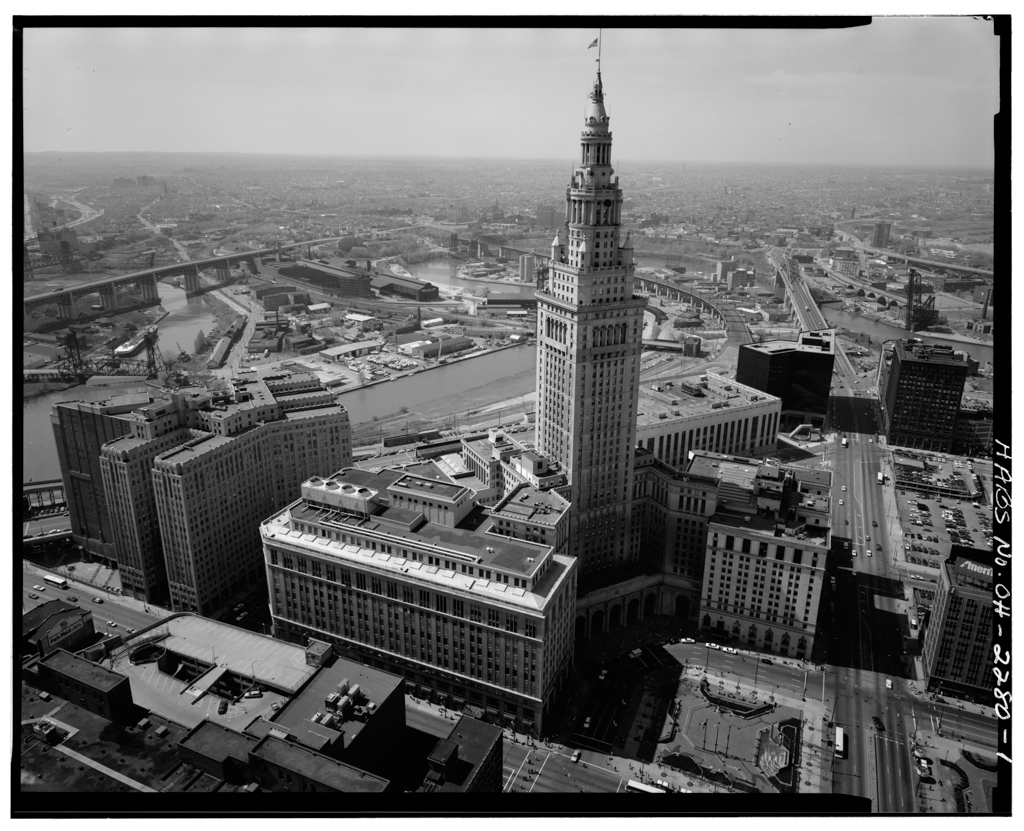
By the beginning of the twentieth century, retail establishments and office buildings dominated Public Square, growing in in size and height as the century progressed. The May Company Department Store, which came to Cleveland in 1899, expanded on the southeast edge of the square for the next decade, until in 1915 it erected a six-story, almost 600,000-square-foot building housing Ohio’s largest department store. Designed by the Chicago firm D.H. Burnham and Company, the white-glazed terra-cotta facade features fine neoclassical detailing accompanied with Chicago windows. Graham, Anderson, Probst and White, Burnham’s successor firm, added two stories in 1931, removing and reinstalling the original terra-cotta cornice on top of the expanded structure. They also designed the 52-story, limestone-clad Terminal Tower (1926–1930), which was the tallest building in the world outside New York City from 1930 until the 1950s. The mixed-use building, which wraps around Public Square’s southern corner, incorporated an existing hotel, a new department store, three office buildings, a post office, and a railroad station into its spatial and programmatic scheme. The next tall building in Public Square arrived only after World War II, when it became Cleveland’s first postwar International Style skyscraper; 55 Public Square (1956–1958, Carson and Lundin) sits on the eastern corner of the Square and is set back on its lot, allowing for a small pedestrian plaza.
After a period of stagnation and even decline in the 1970s, new tall buildings appeared on Public Square in the 1980s. In 1981, Standard Oil Company (SOHIO) announced plans to build the largest office tower in Cleveland, designed by Gyo Obata of Hellmuth, Obata and Kassabaum of St. Louis. Land clearance for this project brought the demolition of two landmarks facing the Square: Daniel Burnham’s Cuyahoga Building (1892) and the Williamson Building (1900) by George B. Post and Sons. Completed in 1985, the 45-story Standard Oil Building is 658 feet high. It was originally intended to be taller than the Terminal Tower, but city officials insisted on a reduced height in deference to the 1930 landmark. (It became the BP America Building after a 1989 corporate takeover; today it is known as 200 Public Square).
The massing of the building acknowledges the environment of Public Square, the irregular street network extending away from the Square, and Daniel Burnham’s Group Plan design of 1903. The building site fronts on the Square and extends eastward, spanning the block from Superior to Euclid avenues, which are not parallel streets. A trapezoidal, eight-story atrium containing retail and office space, along with a landscaped garden, is set back about 60 feet east of the roadway that encircles Public Square. The atrium is focused on Public Square, with flanking wings fronting Superior and Euclid avenues. The building addresses the north to south grade change by shifting the number of floors in each wing, resolving any visual disparity with the stepped design of the atrium roof and wing walls that present a unified design at the same elevation. The atrium also harmonizes with the general scale and massing of nearby buildings and the tower itself is aligned with the north-south axis of the Mall. The tower is situated more than 200 feet east of the Public Square roadway and along with. The atrium, it is folded inward toward the center, keeping the building’s perimeter parallel to both Superior and Euclid avenues.
Stylistically, the building is postmodern, showing more complex profiles and richer materiality than the sheer geometric shapes and glassy facades of the International Style. The exterior is fitted with more than 4,000 panels of red and mahogany granite, combined with bronze-tinted windows on three sides and clear glass on the north elevation. The tower walls, in addition to the fold at the center, are designed with a series of facets extending the building’s full height and culminating in a stepped profile that gestures to the Terminal Tower’s profile.
The next skyscraper erected on Public Square, now known as Key Tower and occupied by the Cleveland-based bank, remains the tallest office building in Ohio. Planned as Society Center, the building was announced in 1988 and completed in 1991. Cesar Pelli designed the 57-story, 947-foot-tall tower with the blessing of city officials who encouraged the company to build the tallest structure in Cleveland, in contrast to the 200 Public Square debate of the previous decade. Although his tower is taller than Terminal Tower, Pelli emphasized that he wanted the design to harmonize with Public Square’s other towers and to respect Root’s Society for Savings building, which the bank still occupied. Key Tower’s postmodern design evokes New York skyscrapers of the 1920s and 1930s: a tower with a series of setbacks gradually reducing the building’s mass, with a pyramidal top and tall spire. The site dimensions fortuitously placed Key Tower’s narrow profile facing Public Square, making it more visually compatible with Society for Savings and Terminal Tower.
Pelli’s scheme also deferred to Society for Savings in other ways. He minimized the presence of the connector between the two buildings by making it narrow, recessed from the facades, and sheathed in black materials. He also adjusted the facade through cladding and a modest setback at the tower’s second and fifth floors to echo changes at the same levels of Society for Savings. Finally, he placed a major setback on the tower at the same level as the Society for Savings’ roofline. Pelli also situated Key Tower several feet back from the facade line of Society for Savings, which also had the benefit of improving the visual connection between Public Square and Burnham’s Mall. While work was underway on the adjacent tower, the interiors of the old Burnham and Root building underwent renovation. Also part of the project was a 400-room hotel on the north side of the site, which is attached to Key Tower.
While the perimeter of Public Square was being transformed in the second half of the twentieth century, Cleveland was also debating changes to its interior. Some plans called for joining the square’s four quadrants into a single space or making two larger spaces; others wanted to change the hardscape and landscaping of the quadrants. By the first decades of the twenty-first century, a major reworking of Public Square finally gained broad support. Designed by James Corner Field Operations of New York, this project was completed in 2016. It replaced the quadrant layout with two large rectangles and removed Ontario Street, the north-south road through the square. Superior Avenue, oriented east-west, was narrowed and restricted for use by buses (which are rerouted for public events). The north rectangle, which receives more sun, includes a large lawn for events and a more informal area for picnics and casual meetings. The south rectangle is anchored by the Soldiers’ and Sailors’ Monument, a cafe that can become a beer garden in summer, and a reflecting pool that can be turned into a skating rink in winter. A curving promenade with colorful native plants and trees borders the square. The design is intended to prioritize pedestrians over vehicles, to increase connectivity among the buildings fronting the square, and to reinforce the importance of Public Square as the center of downtown Cleveland, just as envisioned in the 1796 survey.
References
Barron, James. “Focus: Cleveland; High-Rise Completes 1903 Plan.” New York Times, June 22, 1986.
Corner, James, and Alison Bick Hirsch. The landscape imagination: collected essays of James Corner, 1990-2010. New York: Princeton Architectural Press, 2014.
Daley, Tim, and Prasse, Richard T. “A Monument to Service: The Cuyahoga County Solders’ and Sailors’ Monument.” The Cleveland Civil War Roundtable. Accessed November 15, 2018 http://www.clevelandcivilwarroundtable.com/.
Deegan, Gregory G., and Toman, James A. The Heart of Cleveland: Public Square in the 20th Century. Cleveland: Cleveland Landmarks Press, Inc., 1999.
“History and Architecture.” Old Stone Church. Accessed November 15, 2018. http://www.oldstonechurch.org/.
Johannesen, Eric. Cleveland Architecture 1876-1976. Cleveland: The Western Reserve Historical Society, 1979.
Johannesen, Eric, “Cleveland Public Square,” Cuyahoga County, Ohio. National Register of Historic Places Inventory–Nomination Form, 1975. National Park Service, U.S. Department of the Interior, Washington, D.C.
Lake, D. J. Atlas of Cuyahoga County, Ohio. Philadelphia: Titus, Simmons and Titus, 1874.
Leedy, Walter C., Jr. “Cleveland’s Terminal Tower – The Van Sweringens’ Afterthought.” The Gamut8 (Winter 1983): 39-62.
Schweinfurth, Julius Adolphe papers. Archives and Special Collections, Northeastern University Libraries, Boston, Massachusetts.
Van Tassel, David D., and Grabowski, John J. “Fence War of Public Square.” Encyclopedia of Cleveland History. Accessed November 15, 2018. http://ech.case.edu.
Van Tassel, David D., and Grabowski, John J. “Public Square.” Encyclopedia of Cleveland History. Accessed November 15, 2018. http://ech.case.edu.
Van Tassel, David D., and Grabowski, John J. “Railroads.” Encyclopedia of Cleveland History. Accessed November 15, 2018. http://ech.case.edu.
Van Tassel, David D., and Grabowski, John J. “Soldiers and Sailors Monument.” Encyclopedia of Cleveland History. Accessed November 15, 2018. http://ech.case.edu.