

Adena Park
You are here
Mount Horeb Earthwork


500 BCE–300 CE; 1939 excavation, William S. Webb. 4470 Mt. Horeb Pike.
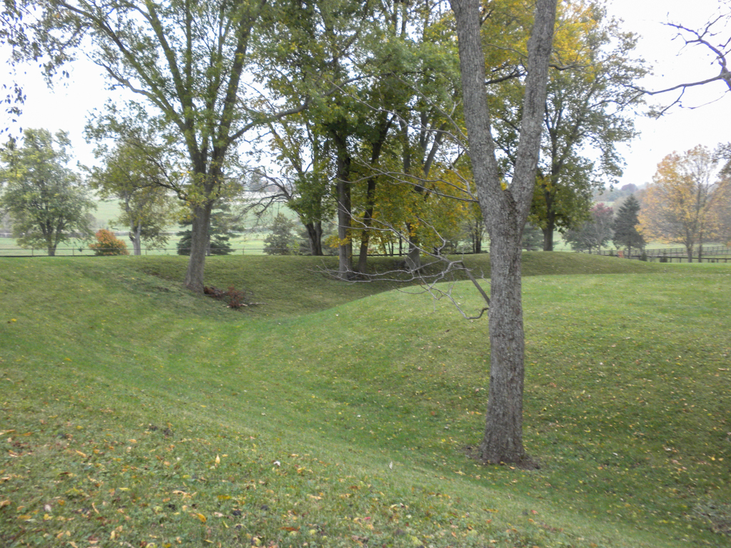
Kentucky’s oldest known inhabited site is a large circular earthwork, nestled deep in the Bluegrass Region, next to (but well above) North Elkhorn Creek. The Adena people built the Mount Horeb Earthwork during the Early and Middle Woodlands Period, between 500 BCE and 300 CE. Though the Adena people, who lived in the Ohio River Valley, were cultivators of crops, they were also hunter-gatherers and followed a fairly mobile lifestyle. While little is known about their spiritual beliefs, the structural evidence of Mount Horeb suggests that they worked collectively and gathered for ceremonial or communal events.
The Mount Horeb Earthwork is a henge, or interior circular area, bounded by a corresponding circular ditch and an enclosing circular embankment. The outer enclosure has a diameter of 300 feet. The embankment is 12-14 feet wide at its base. The 5-foot-high embankment berm was made from the excavated earth of the circular ditch. Baskets were likely used to transport the soil. The 45-foot-wide inner ditch is 8 feet deep. The inner platform circle is 105 feet in diameter. At the western side of the circle is a 33-foot-wide causeway leading hundreds of feet up from near the Elkhorn directly into the inner circle. Both the causeway and the central area represent unexcavated ground surface.
Archaeologist William S. Webb, working in 1939 under the auspices of the Works Progress Administration and the University of Kentucky, found evidence of a 100-foot-diameter paired post enclosure within the inner circle that is apparently earlier than the construction of the ditched embankment. The average diameter of the posts themselves was just under one foot. Whether or not saplings were woven between the paired posts, the enclosure must have looked like a circular standing screen rather than a solid, defensible wall. Regardless, it was clearly a demarcated space in which ceremonies or important events took place. Its repeated use as a ceremonial space is underscored by the fact that very few artifacts have been discovered at the site, presumably because the earthwork was cleaned of detritus after use.
The Mount Horeb Earthwork was first noted by Transylvania University scholar Constantine Samuel Rafinesque in 1820 and was recorded by Ephraim George Squier and Edwin Hamilton Davis in their 1848 Ancient Monuments of the Mississippi Valley: Comprising the Results of Extensive Original Survey and Explorations. Noting the non-defensive nature of such earthworks, Squier and Davis designated them as “sacred circles,” a term that persists in part because its ambiguity corresponds to our lack of understanding of the exact nature and purpose of the 259 prehistoric enclosures surviving in Kentucky.
Mount Horeb is one of several Adena earthworks in the immediate vicinity of a large deposit of the mineral barite near the North Elkhorn Creek. Barite, which turns white when pulverized, was traded by the Adena people and has been discovered in mortuary contexts. A smaller circular earthwork surrounding a squared interior platform lies just to the south of Mount Horeb. Although only a few feet high, the 95 x 82–foot Winchester Farm earthwork is visible from the earthen embankment of Mount Horeb. An Adena burial mound immediately to the west of Mount Horeb and the Winchester Farm mounds existed until at least the 1870s. Uphill to the southwest are the remains of a roughly oval shaped 25-acre earthwork known as the Peter Village enclosure, which was once surrounded by a wooden stockade consisting of more than four thousand posts. Because of its size the Peter Village enclosure is difficult to comprehend in person, but it is discernable on satellite imagery of the site. The Mount Horeb Earthwork at Adena Park is easily visible on Google Earth and is accessible with permission from University of Kentucky Campus Recreation.
References
Lewis, R. Barry. Kentucky Archaeology (Perspectives on Kentucky’s Past: Architecture, Archeology, and Landscape).Lexington, KY: Kentucky University Press, 1996.
Squier, Ephraim George, and Edwin Hamilton Davis. Ancient Monuments of the Mississippi Valley: Comprising the Results of Extensive Original Survey and Explorations.Washington, DC, 1848.
Writing Credits
Coordinator:
Cristina Carbone
If SAH Archipedia has been useful to you, please consider supporting it.
SAH Archipedia tells the story of the United States through its buildings, landscapes, and cities. This freely available resource empowers the public with authoritative knowledge that deepens their understanding and appreciation of the built environment. But the Society of Architectural Historians, which created SAH Archipedia with University of Virginia Press, needs your support to maintain the high-caliber research, writing, photography, cartography, editing, design, and programming that make SAH Archipedia a trusted online resource available to all who value the history of place, heritage tourism, and learning.