


With its population booming in the years after its 1951 incorporation as a municipality independent from Maricopa County, Scottsdale set about developing a Civic Center for the still growing town. Named for U.S. Army Chaplain Winfield Scott, who purchased 640 acres of arable Salt River Valley land in 1888, Scottsdale emerged as a sizeable agricultural settlement and a resort destination at the turn of the twentieth century. Ranching, along with cowboys and cattle drives, was so central to Scottsdale’s development that it became known as “the West's Most Western Town” (adopted as a tourist slogan in 1947). Scottsdale was also a destination for artists, and its cultural reputation was secured when architect Frank Lloyd Wright established his winter home and studio at Taliesin West in 1937. Scottsdale's defense industry emerged with the opening of Thunderbird Airfield II in 1942, and large-scale private industry grew when the Motorola Company opened its Scottsdale plant in 1950. By 1960, the city had grown in population from 2,000 to 10,000 residents and in size from less than one square mile to five square miles.
Recognizing that the rapidly growing municipality needed a civic infrastructure, Scottsdale’s alderman selected a downtown mega-site for a new governmental complex. Also conceived as an urban renewal project, the Civic Center was not without controversy. It originally entailed clearing six city blocks adjacent to the downtown shopping district that city officials regarded as blighted. Mainly residential, the neighborhood consisted of small lots held by multiple owners, which complicated land acquisition. Though two bond elections passed, providing $2.4 million to fund the complex, the first plan failed. Undeterred, city officials next secured $9 million in federal funding from HUD’s Neighborhood Development Program, which enabled them to redevelop a 20-acre, mixed-use site adjacent to the 18-acre barrio of Vista del Camino, which was also targeted for redevelopment. Located in the Indian Bend Wash floodplain, this barrio was home to Yaqui Native Americans and descendants of refugees from the Mexican Revolution, many of them dwelling in adobe houses that Scottsdale officials deemed substandard. As was the case in so many American cities in this period, these inhabitants were relocated into modern housing projects so the Civic Center project could move forward.
After a 1966 city-sponsored Civic Center charrette, a master plan by a local firm, Bennie M. Gonzales Associates, was adopted. Focused principally on the seat of town governance, the center was, in Gonzales’s description, “an open invitation for citizens to participate in their government.” At the same time, the master plan called for a civic and commercial mix that would include a municipal library, convention center, and museums along with commercial buildings around a landscaped pedestrian mall adorned with sculptures, fountains, and pools. Gonzales envisioned a cultural center, a sort of public forum in which civic discussions, educational pursuits, and appreciation for the arts would coexist. A modernist architectural assemblage, with buildings arranged around a central promenade, the Civic Center is a significant artifact of its era and a successful example of the pedestrian mall typology. It sits squarely within the heart of what became downtown: to the west lies Old Town Scottsdale, with its Wild West character; to the north is a contemporary shopping and entertainment district; to the south and east are residential areas. The Civic Center was constructed in stages between 1968 and 1975.
The unifying element of the complex is the L-shaped Scottsdale Civic Center Mall, which has several entrances to ensure access from all surrounding areas. The edges were lined with restaurants, shops, offices, and a parking garage. The eastern end of the plaza is anchored by the City Hall and the Public Library, both buildings designed by Gonzales in 1968 in a sculptural manner that blends modernism with regionalism: the double-thick concrete walls with recessed windows offer cool interiors in the desert heat, while the forms evoke prehistoric adobe structures. The heavily massed volumes, painted in Gonzales’s own formula for “Navajo white” paint, contrast with the vast voids of open greenspace. The Center for the Arts (1974–1975), also a Gonzales design, is sited on the southeastern corner of the mall, while the Doubletree Hotel with convention facilities, designed by Peter A. Lendrum in 1975, was built to the north (it has since been renovated and is operated as an independent boutique hotel). Gonzales’s design for the Public Services Building (1971) on 75th Street was seriously compromised by renovations in 1992 and 2009.
One of the first Mexican-American architects in Arizona, Barnaby (Bennie) Montague Gonzales was a prolific designer, responsible for more than 300 works throughout the state. He blended modernism with a distinct regionalism, emphasizing historical precedent, utilizing native materials, and addressing climactic concerns. Born in Phoenix to parents of European, Mexican, and Native American descent, Gonzales entered the construction business as an assistant in the adobe brick factory of his uncle, Santiago Cahill. This company supplied the materials for such notable buildings as the Heard Museum, Paradise and Camelback inns, and the Arizona Biltmore. After serving as an enlisted man in World War II, Gonzales returned to Arizona and matriculated at the School of Architecture at Arizona State University (ASU), graduating in 1953. In 1954–1955 he continued his architectural education at Universidad Nacional Autónoma de México in Mexico City, where he was exposed to the work of Mexican modernists like Felix Candela and Luis Barragán, as well as the architectural heritage of pre-colonial civilizations like the Mayans and Aztecs. He spent the latter half of the decade pursuing postgraduate studies at ASU while working for local architects James Elmore, Blaine Drake, and Ralph Haver. Over his extensive career, he was honored with some 131 awards, including many from the American Institute of Architects (AIA), three of them for the Scottsdale Civic Center.
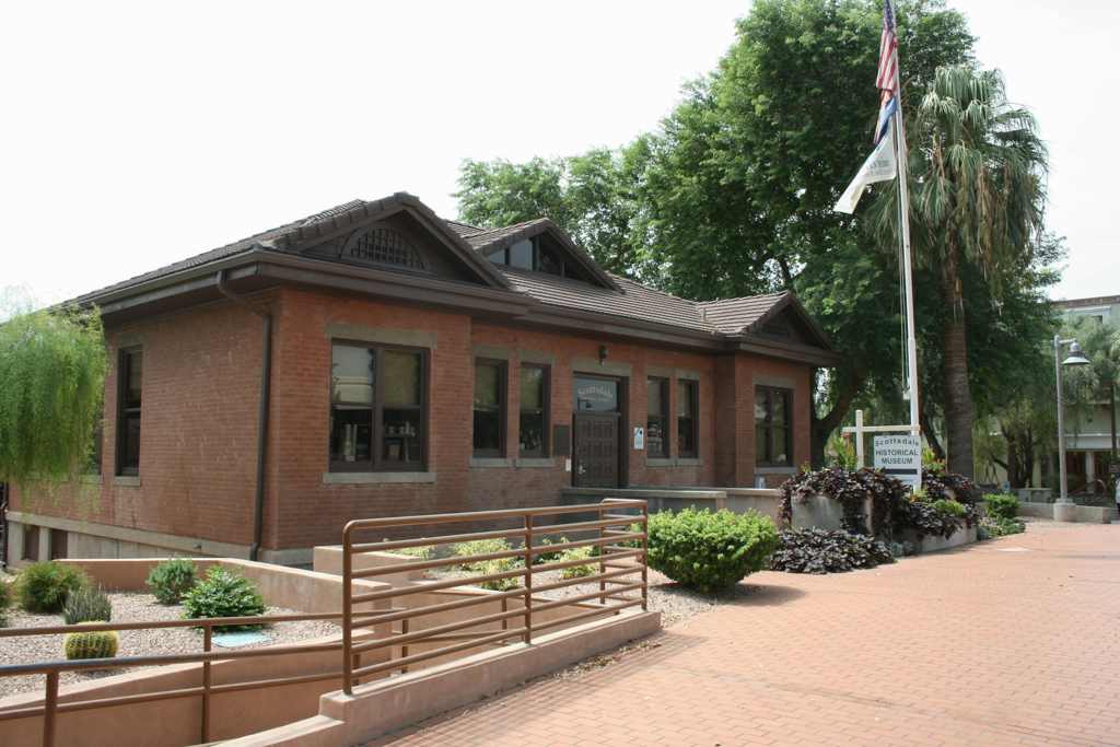
The Civic Center became a popular public space between the touristic Old Town Scottsdale and the government core, which subsequently expanded in all directions. R.A. McIntire and Associates designed the County Courts Building (now the Technology Center) on North Drinkwater Boulevard circa 1975 in a Southwest modern idiom that precisely copies Gonzales’s work at the Civic Center. In the 1970s, a historic building joined the contemporary ones when A. H. Coats’ Little Red Schoolhouse of 1909 was relocated to the southern edge of the mall’s panhandle. It was renovated by Robert Shoenberger and now operates as the Scottsdale Historical Museum. The Ascension Lutheran Church (1952) on Indian School Road was renovated in 1998 and is used by the city. Other notable buildings added to the increasingly dense area around the Civic Center include Taliesin Associated Architects’ parking garage on the southern edge of the mall (1974). Designed in a Southwest modern idiom, the structure has decorative concrete railings and southwestern ornamentation. Jones and Mah designed the Senior Center on East Second Street between 1976 and 1978. In 1999, Will Bruder and Partners renovated the privately owned UA Theaters building for use as the municipally managed Scottsdale Museum of Contemporary Arts (SMoCA).
References
“About Scottsdale: West's Most Western Town.” City of Scottsdale. Accessed September 3, 2015. http://www.scottsdaleaz.gov/.
“Architects: Bennie Gonzales Archive.” Modern Phoenix Neighborhood Network. Accessed August 26, 2015. http://www.modernphoenix.net/.