

Railroad Avenue
You are here
Central Avenue/Route 66


1880–present. Central Ave. between Tramway Blvd. SE and Atrisco Vista Blvd SW.


From 1880 through the 1950s, the urban growth of Albuquerque was driven by the coincident histories of Central Avenue, the city’s main street since 1880, and Route 66, the national highway that joined Central Avenue in 1937 on its way from Chicago to Los Angeles. Tracking the transformations traced by Chester Liebs in Main Street to Miracle Mile, these histories document at once how the railroad and the automobile successively remade the American landscape, and how a downtown main street generated a decentralized city of suburban neighborhoods.
In January 1880, the Atchison, Topeka, and Santa Fe Railroad (AT&SF) selected Albuquerque for its principal depot and rail yard in the Territory of New Mexico. It chose a site 1.5 miles east of the original Spanish settlement, on conveniently flat ground where straight tracks could avoid both the floodplain and the turns of the Rio Grande. One month before the railroad reached Albuquerque on April 5, three local businessmen formed the New Mexico Town Company as a subsidiary of the AT&SF to develop the 3.2 acres they bought up for the planned depot and New Town. Walter G. Marmon, a civil engineer who worked with the railroad, surveyed and laid out this New Town with a grid placed beside the projected tracks and bisected by Railroad Avenue. Leading west to what became (by default) the “Old Town,” Railroad Avenue also continued east across a mesa toward Tijeras Canyon, following a wagon trail that had been surveyed along the 35th Parallel in 1857.
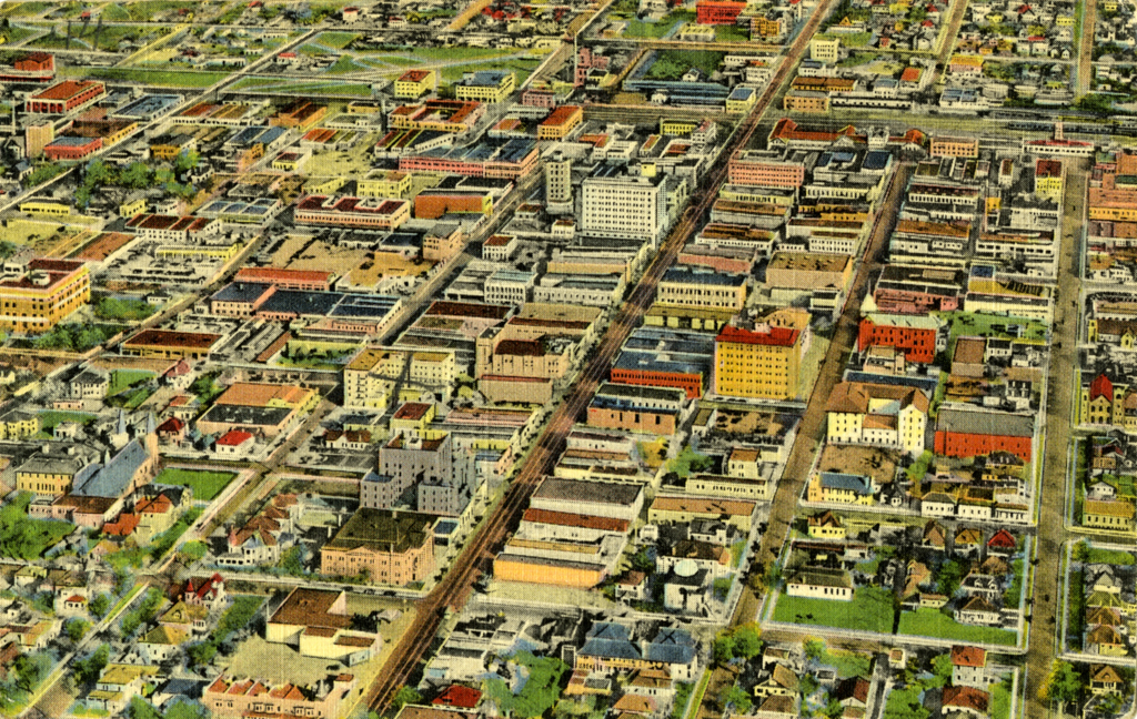
Anchored by the AT&SF locomotive repair shops, New Town Albuquerque became New Mexico’s primary warehousing, distribution, mercantile, and manufacturing hub. A thriving downtown of hotels, saloons, stores, and professional offices replaced Old Town as the center of commercial activity. The Huning Highlands Addition, platted in 1880 across the tracks from New Town, was the city’s first residential subdivision. This inaugurated a pattern of suburban development that saw the Perea Addition platted between New Town and Old Town in 1881, and the University Heights Addition platted on the East Mesa in 1906, across Railroad Avenue from the University of New Mexico (founded in 1889).
In 1881, the Street Railway Company started operating mule-drawn streetcars between New Town and Old Town. In 1904, the Albuquerque Traction Company introduced electric streetcars, which were extended in 1908 by the Highland Line that ran out to the university and University Heights. In 1912, Railroad Avenue was renamed Central Avenue at the urging of D.K.B. Sellers, the developer of University Heights who was then Albuquerque’s mayor. Sellers hoped that the locational name would attract property owners out to the East Mesa by identifying this remote area as an integral continuation of the already sprawling city.
By then, the age of the railroad was yielding to a new age of the automobile. The first automobile entered New Mexico in 1897, and in 1908 Albuquerque began licensing the “horseless carriages” that were suddenly invading its streets. When New Mexico became a state in 1912, it registered 470 vehicles, which rose to 17,000 by 1920 and 84,000 by 1930.
Recognizing that mobility brought increased accessibility, Albuquerque annexed 4,166 acres of land to the east of the University of New Mexico along Central Avenue. The College View and Monte Vista subdivisions were platted in 1926 as the city’s first car-oriented suburbs. To attract families, land in the Monte Vista subdivision was set aside for the Monte Vista School (1930–1931, T. Charles Gaastra), while the Monte Vista Fire Station (1936, Ernest Blumenthal) was built on Central Avenue to provide fire protection and thus reduce the cost of insurance to property owners. Concurrently, Albuquerque began paving its streets: 21.5 miles by 1923 and 53 miles by 1929. In 1928, the tracks along Central Avenue and other streets were paved over, and buses replaced streetcars with more flexible routes that were better able to serve the city’s dispersed subdivisions.
The city’s mechanization was paralleled by the creation of state highways, which New Mexico began planning in 1912 and began grading in 1917 with funding from the Federal Aid Road Acts of 1916 and 1921. In 1926, following the decision in 1925 to integrate the country’s state highways into a national system with consistent numerical designations, New Mexico’s major north-south highway became part of U.S. Route 85, and its major east-west highway became part of U.S. Route 66.
Route 66 entered New Mexico from the east along the historic wagon trail on the 35th Parallel. But difficult terrain separating Santa Rosa from Albuquerque, culminating with Tijeras Canyon between the Sandia and Manzano Mountains, forced Route 66 into a detour north around the mountains to Santa Fe. There it joined Route 85 for the 60 downhill miles to Albuquerque. Entering the downtown on Fourth Street, the two highways split again at the intersection of Fourth and Central Avenue: Route 66 turned west to leave the city along Central while Route 85 continued south on Fourth.
In 1937, Route 66 was straightened to head due west from Santa Rosa through Tijeras Canyon following State Highway 6, which had been constructed in anticipation of this realignment. Route 66 now traversed Albuquerque along the entire length of Central Avenue. With Routes 66 and 85 meeting downtown at Central and Fourth, the city’s principal commercial streets had become synonymous with two national highways. Originally unpaved in New Mexico, Routes 66 and 85 were both paved in the 1930s with federal funding from the Works Progress Administration and labor from the Civilian Conservation Corps.
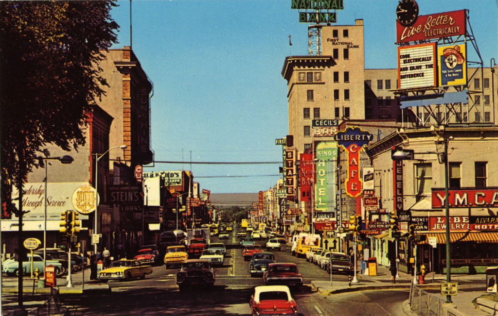
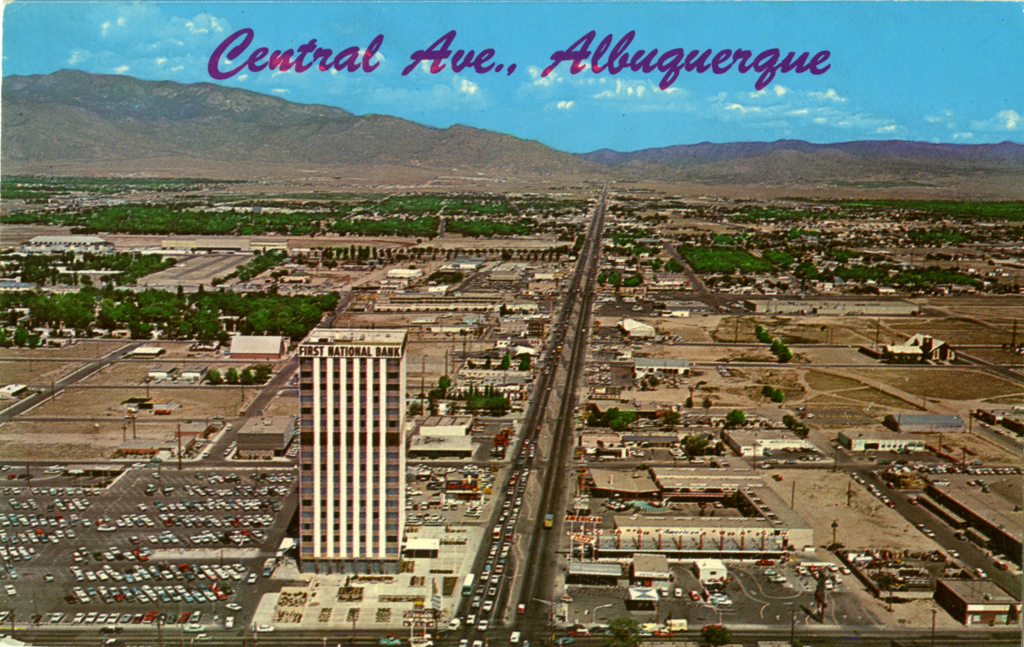
Like its streets, Albuquerque’s buildings were shaped by the railroad and the automobile. The Alvarado Hotel (1901–1902, Charles Whittlesey), built in the California Mission Style by the AT&SF in partnership with the Fred Harvey Company, anchored downtown Albuquerque alongside the tracks at the southeast corner of First Street (initially Front Street) and Railroad Avenue. As the downtown expanded beyond its original western border at Third Street, the first wooden buildings were replaced after 1900 by ones of brick and then reinforced concrete, often modeled after precedents imported from the Midwest. Typical buildings from this period include the Rosenwald Building (1909–1910, Trost and Trost), New Mexico’s first department store and first reinforced concrete structure, at the corner of Railroad Avenue and Fourth Street; and the First National Bank Building (1920–1924, Trost and Trost), New Mexico’s first “tall office building,” on the 200 block of Central Avenue.
The inauguration of Routes 66 and 85 encouraged the development of Central Avenue during the late 1930s and 1940s as both the city’s commercial downtown lined with national retail chains (Sears, Woolworths, Montgomery Ward, etc.) and as a tourist strip lined with curios shops. Albuquerque began to market itself to passing motorists as “the crossroads of New Mexico.” In 1926, the Fred Harvey Company had launched its “Indian Detours”: railroad passengers could stop off at either the Castañeda Hotel in Las Vegas or the Alvarado Hotel in Albuquerque for automobile or bus tours of scenic New Mexico before resuming their train trip at the other end. Complementing the Pueblo Revival architecture of Trost and Trost’s Franciscan Hotel (1923, demolished 1972), the nearby Art Deco KiMo Theatre (1926–1927, Carl Boller) on the 400 block of Central Avenue captured this marketing image with an eclectic profusion of Indian and Southwestern details.
The realignment of Route 66 in 1937 confirmed Central Avenue’s mutating identity from a downtown main street to a tourist strip on a national highway. Maisel’s Indian Trading Post (1937–1939, John Gaw Meem), on the 500 block of Central Avenue, caught the eye of passing motorists with a facade of Indian murals and motifs. The automobile’s phenomenon of speed had forced a radical rethinking of the marketing logic found in the Alvarado Hotel’s “Indian Room,” a completely interior space that relied for its clientele on a captive audience of train travelers.
The El Vado Motor Court (1937), at the 2500 block of Central Avenue where Route 66 headed west out of town, is a surviving example of the motels that once lined the highway at both ends of Albuquerque. Competing with downtown hotels like the Alvarado and the Franciscan, this new type of accommodation directly served the automobile with two wings of rooms that line a central court for easy access and parking off the highway. El Vado’s Pueblo Revival architecture offered the transient lodger a stereotypical experience of New Mexico.
Out on the East Mesa, at what was then the city’s edge at 3226 Central Avenue, the Jones Motor Company (1939, Thomas Danahy) was a combined Texaco service station and Ford dealership that catered to both arriving motorists and residents of the nearby College View and Monte Vista neighborhoods. Like the motel, the service station was invented for the automobile, dispensing fuel and mechanical repairs from a convenient, drive-through lot, whose efficiency was guaranteed in this case by its streamlined architecture.
The combination of mass tourism and people fleeing the Dust Bowl for California brought an explosion of vehicles on Route 66. Traffic in New Mexico increased by 300 percent during the 1930s, with 50 to 66 percent coming from out-of-state. In 1938, Albuquerque received federal funding to build a railroad underpass for Central Avenue to expedite the stream of cars downtown.
Rationing of gas, tires, and parts slowed travel on Route 66 during World War II. But traffic quickly recovered after the war and accelerated into the 1950s. Albuquerque stretched further west and east along Central Avenue, pulled outward by commercial decentralization as much as by suburban development. The Nob Hill Business Center (1946–1947, Louis Hesselden), built at the far east end of the University Heights Addition, was New Mexico’s first drive-in shopping center, with a supermarket, shops, and professional offices clustered around a parking lot right off Central Avenue.
By the mid-1950s, the same forces that had impelled Central Avenue and Route 66 as engines of Albuquerque’s growth were making them obsolete. In 1956, the Federal Aid Highway Act authorized a new system of interstate highways: I-40 replaced Route 66 and I-25 replaced Route 85 in New Mexico. Completed in 1966, these interstates parallel rather than follow Routes 66 and 85 through Albuquerque and intersect at the Big-I a mile east of their historic crossing at Central and Fourth. This segregation of highway from local traffic at once alleviated the congestion on city streets and threatened their commercial life. Winrock Center (1959–1961, Victor Gruen) opened alongside the new I-40 and competed simultaneously with downtown stores and suburban satellites like the Nob Hill Business Center by offering the convenience of New Mexico’s first shopping mall.
The automotive strip of motels, gas stations, restaurants, and stores along Central Avenue slowly eroded, while the Alvarado Hotel and other downtown structures were demolished in the 1970s in a misguided program of “urban renewal.” Policies and attitudes began to shift in the 1980s, initiating campaigns of preservation and commercial redevelopment that even saw the Alvarado Hotel recreated in a questionable simulacrum called the Alvarado Transportation Center (1999–2002, Dekker, Perrich, Sabatini). More convincingly, the Beach Apartments (1983–1986, Antoine Predock) were an early example of the ongoing incremental and experimental effort to repopulate Central Avenue with condominiums and apartment buildings. A short distance from El Vado Motel, the Beach Apartments celebrate Route 66 with polychromatic zigzag decoration and neon lighting.
In 2016, Central Avenue’s historic identity as an automobile highway was threatened again, this time by a controversial, federally funded municipal project called ART for Albuquerque Rapid Transit. Completed in 2017 and extending a distance of nine miles through the city, ART cuts car traffic to a single lane in each direction and runs dedicated high-speed bus lanes down the middle of the street.
References
DeWitt, Susan. Historic Albuquerque Today: An Overview Survey of Historic Buildings and Districts.2nd ed. Albuquerque, NM: Historic Landmarks Survey of Albuquerque, 1978.
Fergusson, Erna. Albuquerque. Albuquerque, NM: Merle Armitage, 1947.
Kammer, David. The Historic and Architectural Resources of Route 66 Through New Mexico.Santa Fe: New Mexico Historic Preservation Division, 1992.
Kammer, David, “The Twentieth-Century Suburban Growth of Albuquerque, New Mexico,” Bernalillo County, New Mexico. National Register of Historic Places—Multiple Property Documentation Form, 1997. National Park Service, U.S. Department of the Interior, Washington, D.C.
Liebs, Chester H. Main Street to Miracle Mile: American Roadside Architecture. 2nd ed. Baltimore: Johns Hopkins University Press, 1995.
Simmons, Marc. Albuquerque: A Narrative History. Albuquerque: University of New Mexico Press, 1982.
Slaney, Deborah C. Jewel of the Railroad Era: Albuquerque’s Alvarado Hotel.Albuquerque, NM: Albuquerque Museum, 2009.
Usner, Don J. New Mexico Route 66 On Tour: Legendary Architecture from Glenrio to Gallup. Santa Fe: Museum of New Mexico with the New Mexico Historic Preservation Division, 2001.
Writing Credits
Coordinator:
Christopher C. Mead
Regina N. Emmer
If SAH Archipedia has been useful to you, please consider supporting it.
SAH Archipedia tells the story of the United States through its buildings, landscapes, and cities. This freely available resource empowers the public with authoritative knowledge that deepens their understanding and appreciation of the built environment. But the Society of Architectural Historians, which created SAH Archipedia with University of Virginia Press, needs your support to maintain the high-caliber research, writing, photography, cartography, editing, design, and programming that make SAH Archipedia a trusted online resource available to all who value the history of place, heritage tourism, and learning.