

Spanish conquistador Juan de Oñate marched north in 1598 from central Mexico to the Rio Grande Valley near present-day El Paso. Oñate carried the Christianity of Mediterranean culture to far outposts, in this case Pueblo tribes along the river in present-day New Mexico, where he induced the natives to build a church in each village. After the Pueblo Revolt of 1680, sending Oñate and his legions back south, a few hundred Christian converts retreated with the Spanish downstream to El Paso del Norte (the Pass of the North). Within two years the Tigua and Piro refugees built adobe churches (EP60) on the central plazas of their new villages along the river, near current-day El Paso. Flooding and a change in the river’s course in 1829 required rebuilding the two mission churches on higher ground. These two mid-nineteenth-century churches—Corpus Christi de la Ysleta (EP60.1) for the Tigua and Nuestra Señora de la Limpia Concepción de Socorro (EP60.2) for the Piro and fellow transplants—survive today as descendants of Pueblo and Spanish traditions on the westernmost edge of Texas (see the El Paso del Norte, Onate, Isleta, and Socorro entries in the Handbook of Texas).
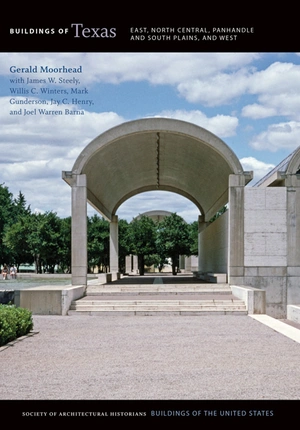
Fast forward to the twentieth century: foodstuffs entrepreneur Kay Kimbell based a consumer-products empire on the staple of Mediterranean diets—grain—through its storage, processing, distribution, and sale. Kimbell and his wife, Velma, began collecting museum-quality paintings in 1931, and upon Kay’s death in 1964 Velma devoted their fortune to building the best gallery Kimbell Milling Company dollars could buy, hiring Louis I. Kahn to design the building (FW33). Kahn and his engineer, August Komendant, followed a design program that connected the Kimbell fortune’s grain origin with the simplicity of ancient granaries.
These iconic buildings in El Paso and Fort Worth follow classical Mediterranean traditions, from their introduction into Spanish and native North America to the modern United States’ culture composed of many immigrant groups. While seventeenth-century builders depended on simple tools and ancient construction methods, their twentieth-century successors operated in a complex society that could assign any stylistic precedent and choose to shape new materials into every imaginable building commission.
ADVANCES INTO TEXAS
This second volume of Buildings of Texas on the east, north, central prairies, west, and Panhandle regions offers a geographical extension of volume 1, which explored the state’s central, south, and Gulf Coast counties. Volume 1 covered much of the Spanish entrada from the south, and the Texas coastal counties also hosted the most expansive early Euro-American development, fanning inland from deep-water ports of immigration and commerce in the early 1800s. This second volume describes the buildings of Spanish and Mexicans from the south and southwest and Anglo- and African Americans’ entry into Texas from the east and north beside and across the Red River and westward along rivers, trails, roads, and railroads.
Historian Frederick Jackson Turner wrote in 1925, “the United States was always beginning over on its outer edges as it advanced into the wilderness.” He explained that the westward flow of the population installed continuous lines of new towns serving promising new agricultural lands that always loomed in the direction of the setting sun (Turner, “Significance of Section”). Texas historian Walter P. Webb similarly wrote in 1952 that the westward advance in his home region stalled between about 1850 and 1880 at the 98th meridian (just west of Fort Worth) because that’s where annual rainfall declined dramatically (Webb, Great Frontier). While neither Turner nor Webb tackled the question of what East Texas might have in common with West Texas, they legitimized our approach in this book of moving the story of Texas settlement and architecture generally—after the Spanish entry from the south—from east to west in keeping with conventional American frontier sequences since the early 1800s.
The crossing of cultures in Texas follows ancient movements still evident in corridors across the state. One foot trail followed reliable water sources, north from Central Mexico to the Rio Grande at what is now El Paso and along that river north to what became Santa Fe. The Spanish named their north-south corridor El Camino Real de Tierra Adentro (the King’s Highway to land within). Another trail skipped west from what is now the state of Louisiana along the Red River to its source in the present-day Texas Panhandle and overland farther west. Much of this east-west route in Texas exists today but shifted slightly south from the Red River bluffs to be traversed by U.S. 82 and 287. The same corridor shifted farther south in the mid-twentieth century to I-30 and I-20, following the route built by the Texas and Pacific Railway in 1873–1881 from Texarkana to El Paso.
SHELTER AND SETTLEMENT
Some of the oldest evidence of prehistoric shelter and architecture in present-day Texas is found in the rock shelters (EL19, SS33) adorned with pictographs. As early as 5000 BCE, when humans first moved along a north-to-south migration through North America, hunter-gatherers stopped to rest, eat, and paint effigies on walls under stone shelves overlooking desert valleys of the Pecos River and Rio Grande.
To the east, around 800 CE Caddo people established Mississippian woodland culture villages of circular-plan thatch buildings and huge ceremonial mounds (LC14) throughout what is now northeast Texas in the lush drainages of the Red and Neches rivers (for the Landergin Mesa see “Understanding Variation”). Plains Village cultural groups (see TB10), semi-migratory bands from present-day Nebraska from c. 1100 to c. 1500 settled in the Canadian River valley of the Panhandle.
Spain claimed a vast landscape now partly defined by Texas in 1540–1542, but Spanish settlement along the Rio Grande near present-day El Paso only began in the late seventeenth century, with missions (EP60) and, in 1789, the Presidio San Elizario (EP60.3). A French incursion in 1685 into present-day coastal Texas had ignited anew Spanish interests north of the Rio Grande. By 1690 the Spanish had established Mission San Francisco de los Tejas, now reconstructed in a state park (LC13), at Weches and a mission in Nacogdoches in 1719, probably of log buildings. Spanish outposts also emerged between El Paso and San Antonio. Mission Santa Cruz de San Sabá and the Presidio San Luis de las Amarillas (SS38), on the other hand, were built in 1757 for protection from Comanche raids near present-day Menard (see the Nuestra Señora de Guadalupe Mission and Santa Cruz de San Sabá Mission entries in the Handbook of Texas).
The U.S. purchase in 1803 of France’s immense North American colonial claim included a southern boundary that followed the Red River along present-day North Texas. To explore and evaluate the purchase, President Thomas Jefferson not only dispatched Lewis and Clark but also assigned equal expectations to the “Grand Excursion” led by Thomas Freeman and Peter Custis westward across the annexed territory’s southern boundary. Custis is credited as the first biologist to record natural features of the western United States, as he and Freeman moved up the Red River toward what their president hoped was a water passage most of the way to Santa Fe. Alas, they met Spanish troops at Spanish Fort near present-day Henrietta on the Red River and hastily retreated (Flores, Jefferson and Southwestern Exploration).
Reports that a water route from the Mississippi River would float pioneers deep into the Louisiana Purchase brought settlers by flatboat in 1816 to what is now northeast Texas near Clarksville. Word spread in the East of this fertile outer edge. Shallow draft steamboats from New Orleans could ply the Red River to Jonesborough (until 1843, when it was devastated by a flood), a settlement north of present-day Clarksville, to intercept overland trail traffic from St. Louis. Settlers along this fertile stretch of the Red River thrived, but disputes between the United States and Spain, then Mexico, discouraged permanent settlement on either side. Meanwhile, politician and soldier of fortune Sam Houston first entered Texas here in 1832, crossing the Red River at Jonesborough along a new military road across Indian Territory. Houston made his way south to the larger settlements between the Gulf Coast and San Antonio. His fellow Tennessean David Crockett also traveled on the Red River to the Jonesborough landing in 1835, where he stepped into a widening dispute between Anglo-Americans and their Mexican provincial government.
FROM MEXICO TO THE REPUBLIC OF TEXAS
In early 1836 Sam Houston rose to become commanding general of the rebel Texan army, and Crockett arrived at San Antonio just as a large Mexican army besieged the Alamo. Mexico’s president Antonio Lopez de Santa Anna conquered the Alamo and Crockett, but he stumbled and was routed by Houston’s main force at San Jacinto near present-day Houston on April 21, 1836. The Republic of Texas, indisputably north to the Red River but with a murky southern boundary, maybe the Nueces River, emerged from the latest westward surge of Anglo-Americans.
Significantly, the new republic took charge of all public lands and flowing waters and assumed the considerable bureaucracy associated with land grants and sales. Slavery entered commerce and agricultural productivity as a legal enterprise, further linking Texas with the labor-intensive economy of the U.S. South. Texas now offered a potential agrarian (and largely slave-powered) opportunity to settlers, as well as real estate speculation on a grand scale, and the young republic absorbed tens of thousands of immigrants in the 1830s and 1840s. The great technological introduction in the 1830s of steam-powered sawmills accelerated the urbanizing boom deep into the growing trade centers of the East Texas forests, such as Nacogdoches, Liberty, and Jefferson.
Another Tennessean, attorney John Neely Bryan, probably crossed into Texas at Jonesborough in 1839 and followed an old southwesterly trace to the convergence of the three forks of the Trinity River. Bryan settled here and built a single-pen log cabin (DS4) from the local post oaks, and in 1845, on the eve of Texas statehood, he and a handful of neighbors established a town they named Dallas for then-U.S. vice president George Dallas (see entries in the Handbook of Texas for Dallas [City of] and John Neely Bryan). (Dallas is officially unsure of its namesake, but several new Texas towns and counties named themselves in 1845 and 1846 for U.S. government officials in hopes of boosting their chances in the U.S. Congress for approval of Texas annexation.) With admission to the United States as a slave state that year under President James Polk, Texas settlement by southern migrants increased dramatically.
The favored inland port of entry now was Jefferson, which accommodated shallow-draft steam paddle wheelers from New Orleans on a tributary of the Red River. Jefferson and the Red River turned out not to be the best way to Santa Fe, but the inland port thrived and rivaled Galveston for decades as a major shipping point for cotton heading to New Orleans and for finished goods making their way to Dallas and beyond.
EARLY STATEHOOD
Texas officially joined the Union as the 28th state in early 1846, retaining its estimated 225 million acres of public lands, as well as its considerable public debt as part of the annexation treaty. From a population of about 50,000 in 1836 the republic’s liberal immigration policies resulted a decade later in a census count of 125,000 upon annexation. By 1850, the state’s population reached 155,000, just as the congressional compromise of that year created the Territory of New Mexico and eventually parts of four new states from far-flung lands claimed by Texas for compensation exceeding $10 million. With its debts paid and cash in hand, the state government built public buildings in its heretofore tentative capital city of Austin. And substantial U.S. Army budgets produced masonry fort buildings where possible, including Fort Belknap on the Butterfield Overland Mail route west of Fort Worth.
The U.S. military grew to a major presence in the state and an important engine of its economy and building innovations. The defeat of Mexico in 1848, launched primarily from Texas, brought a federal strategy to guard the U.S. southern frontier against Mexico and the western frontier from the nomadic Comanche, Apache, and other tribes. The California Gold Rush beginning in 1848 accelerated the need for safe passage across Texas for fortune seekers heading west. The federal government sponsored several Pacific Railroad surveys between 1853 and 1855, including two across Texas. Much needed information resulted, from soil evaluations and geology to water courses and springs (see the Exploration entry in Handbook of Texas).
From its primary supply base in San Antonio, the U.S. Army’s assignments protected supply lines and stage routes that followed the Pacific Railroad surveys, reaching El Paso and beyond. Western frontier fort design and construction (see Federal Fort Planning in Texas: History and Federal Fort Planning in Texas: Construction on pp. 418–19 and 450–51) followed a standard plan, with a parade ground as a central space, officers’ quarters along one side, and enlisted men’s barracks on the other. Stables were placed downwind of daily activities, and hospitals enjoyed a sanitary distance as well.
The Texas population had quadrupled to 600,000 by 1860, and a few substantial towns emerged across the eastern third of the state, including Jefferson and Marshall, all of which exploited water traffic to build their urban centers. Ambitious town officials sought railroad connections and urged cross-state connections.
WAR AND RECONSTRUCTION
Texas joined the Confederacy in March 1861. Governor Sam Houston, who recommended either staying in the Union or declaring independence once again, was joined by representatives from North Texas along the Red River and from the Hill Country. But the legislature’s pro-Unionists were outvoted and returned to their homes to wait out the war (19 of 154 counties voted against secession).
Munitions factories were constructed in the Jefferson and Marshall areas, and prison camps were established near Tyler. The U.S. Army’s western frontier forts initially claimed by Confederate militia emptied as troops and arms moved east toward battles far from Texas. Shortly after the war ended a Union occupation force landed at Galveston to place the territory under martial law and to announce that all slaves in Texas were free. That was June 19, 1865, still celebrated as “Juneteenth,” Emancipation Day in Texas and elsewhere.
During Reconstruction (1865–1874 in Texas) a few individuals prospered in the postwar barter economy. For example, former Confederate general Sam Bell Maxey built his Italianate house (1868; MC45) in Paris of cypress (probably milled in New Orleans and shipped via Jefferson) after winning a lawsuit over wartime confiscated cotton. In rural Texas, home to by far the largest population block, farmers dressed their log dwellings with milled siding or built stud- or balloon-framed houses. African Americans established “freedmens” towns in rural areas and on the edge of cities, such as Deep Ellum near Dallas, to enter urban labor pools. For all rural Texans, log and clapboard country churches and schools served as modest urban centers, sometimes with both functions inside a single building and used by multiple congregations on Sundays.
As settlements spread west and north across the Trinity and Brazos rivers, new county lines repeated the formula of uniform 30 x 30–mile quadrants. This 900-square-mile county ideal allowed a farmer from the farthest corner of the county to drive his team and wagon to the central county seat on monthly trading days and return by sundown.
Slow-moving steamboat traffic on meandering rivers, connecting to wagons slogging through pine forests and across Blackland Prairies, motivated investors to build railroads. From the state’s 470 miles of track in 1861, the Texas and Pacific Railway (T&P), the Fort Worth and Denver City (FW&DC), the Houston and Texas Central (H&TC), the International and Great Northern (I&GN), the Galveston, Harrisburg and San Antonio (GH&SA), and other connecting lines operated nearly 10,000 miles of track by 1900, and the southern intercontinental link was made in December 1881 at Sierra Blanca by the T&P and Southern Pacific. Financed by state and federal land grants, typically 20 sections (12,800 acres) per mile, the railroads platted towns and farms and promoted investment and settlement through land sales. They provided transportation for the new settlers’ crops and goods and brought back the world’s goods to build the new towns, farms, and ranches. Well-timed investors ensured that new railroads connected their favored older towns, such as Fort Worth and Marshall, but the rails bypassed many older communities, causing their rapid decline. Some old towns got railroads but still lost their former commercial glory, including Jefferson and San Augustine in the east and Buffalo Gap in the west. Towns at the junctions of mainline railroads won the biggest economic benefits: Paris, Gainesville, Wichita Falls, Amarillo, and Dallas.
The new commodity and transport entrepreneurs rewarded themselves with lavish houses in fashionable, if not always up-to-date, styles. One of the first great post–Civil War cattle barons, Daniel Waggoner, built a brick Italianate villa (DD27) in 1883 as the anchor of his giant ranch across the prairie near Decatur.
Balloon-frame and box-frame houses of milled lumber appeared along rail lines like wildflowers in spring. The central hall breezeway prevailed even within complex designs, and pyramidal-roofed houses were ubiquitous, particularly among workers near industries. Mail-order buildings of all sorts arrived by rail, as well as the catalogues from which to order them. The Queen Anne houses of George F. Barber, jails from the Pauly Jail Building Company, prefabricated iron bridges by the King Iron Bridge and Manufacturing Company, and cast-iron and pressed metal storefronts by Mesker Brothers and others could not have been possible without the railroads.
THE LATE NINETEENTH CENTURY/URBAN GROWTH
The railroad boom shouldered prosperity and a surge of construction across Texas. Several engineering and architectural advancements converged in the 1880s that led to large and elaborate buildings. Texas’s post–Civil War prosperity paid for these buildings, boosted after 1881 by state laws allowing counties to sell bonds and leverage local taxes for new courthouses, jails, and road bridges. Architects such as James Riely Gordon and his contemporaries rode the rails between jobs, along with the building materials from Burnet (red granite), Pecos (red sandstone), Ferris (brick), Lufkin (lumber), countless Texas limestone quarries, and anywhere else in the United States from which iron, steel, glass, hardware, and specialty materials were issued.
The town of Granbury in Hood County, a typical example, developed during this period as a county seat and regional market center flush with cotton money, especially after the Fort Worth and Rio Grande Railway reached the town in 1887. In 1891, Wesley Clarke Dodson of Waco completed for Hood County one of his many Second Empire courthouses (WC20), crowned by a multistoried clock tower beckoning travelers from miles away. One- and two-story commercial buildings of limestone and brick developed on the Granbury square (WC21) through the 1880s and 1890s.
Dodson’s limestone Second Empire compositions and small but detailed classical columns on his courthouses of the 1880s and 1890s hinted at the emerging Classical Revival and Beaux-Arts civic planning. Chicago’s 1893 World’s Columbian Exposition caught the state’s attention. A few courthouse architects picked up on Chicago’s City Beautiful theme at the turn of the twentieth century, notably J. Riely Gordon as seen in his Harrison County Courthouse (LT7) in Marshall.
At Fort Worth, the powerful Gulf, Colorado and Santa Fe Railway erected a new depot (FW15) in 1899 reflecting Beaux-Arts ideals, but the building stood alone without a connecting civic plaza or prominent axis shared with other civic edifices. Similarly, in 1906 El Paso built a new Union Station (EP12) designed by Daniel H. Burnham’s Chicago firm, but with no civic plan to serve as foreground. Beaux-Arts classical forms were also introduced to several towns in the libraries funded by philanthropist Andrew Carnegie, as, for example, in Cleburne (WC37) and Terrell (KR5), and more than two dozen other Texas cities.
The U.S. Army greatly expanded its Texas facilities around the turn of the twentieth century, notably at Fort Bliss (EP49) in El Paso. At each old post, a parade ground defined axial open spaces, flanked by ever-larger barracks and administration buildings, with classical motifs but reflecting climate adaptation through deep roof extensions over continuous porches.
College and university campuses in Dallas (Southern Methodist University; DS70), Fort Worth (Texas Christian University; FW47), and Lubbock (Texas Technological University [Texas Tech]; LK17) combined the best of axial planning with sophisticated architectural themes. Southern Methodist University chose a Georgian Revival theme for its early buildings, including anchor Dallas Hall (DS70.1), a version of Thomas Jefferson’s Rotunda at the University of Virginia; Texas Tech developed a Spanish Renaissance theme based on Iberian originals rather than Spanish colonial New World models.
Coal- and oil-fired steam plants propelled the machinery behind these Progressive Era construction projects and the mechanical systems and creature comforts within the buildings. Electricity from local power plants became the norm for large and many small towns after the turn of the twentieth century along with mass transit, including trolley lines to planned residential developments. Streetcar suburbs multiplied beyond the increasingly crowded and commercial city centers.
INTO THE TWENTIETH CENTURY
In 1900, Texas’s population had risen to three million, making it the sixth largest state in the Union. The majority of Texans lived in small towns and on farms and ranches, and most cities remained under fifty thousand in population. Nevertheless, new architectural ideas reached even the smallest communities. Dallas architect James Edward Flanders’s small-town churches, such as the First United Methodist Church (KR16) in Pittsburg, caught the spirit as well as the important foliate details of Louis Sullivan’s ornamentation.
Others brought firsthand experience of Sullivan’s and Frank Lloyd Wright’s work to Texas. Henry C. Trost from Chicago designed Mission Revival buildings in Arizona and New Mexico before settling in El Paso in 1903. His own house (EP34.1) of 1909 shows various progressive influences. But Trost was no copier. He absorbed the latest ideas and reinterpreted them for his clients, and his architectural influence in West Texas lasted for decades to come. The 1917 Old Main Building (see EP36) Trost designed for the Texas School of Mines and Metallurgy (now the University of Texas at El Paso) issued from the pages of a 1914 National Geographic magazine article on Bhutan and inspired the campus’s style.
The Dallas firm of Lang and Witchell modeled itself on Chicago’s Adler and Sullivan by pairing an engineer (Otto Lang) with a designer (Frank Witchell). This team excelled after 1905 in and around Dallas and Fort Worth with high-rise commercial buildings and houses for the elite, all under strong Chicago and Prairie School influence. The firm’s chief designer, Charles Barglebaugh, had extensive Chicago experience.
Thus, national design ideas gained root in Texas, including a handful of interesting responses to Bertram Grosvenor Goodhue’s Nebraska State Capitol constructed in the 1920s. The Wichita Falls firm of Voelcker and Dixon produced a series of Goodhue-inspired gems highlighted by their Cottle County Courthouse (PH1) at Paducah in 1930, just as the West Texas dryland agricultural boom stumbled and began a long fall.
The U.S. Treasury Department stimulated a trend for classicism with buildings such as the 1917 U.S. Post Office (EP22) in El Paso and a number of contemporaneous postal centers across the state. Daniel H. Burnham’s mammoth white, classical Union Station in Washington, D.C. inspired Jarvis Hunt’s Dallas Union Station (DS7) of 1916. Soon some architects interpreted this form for courthouses, including Henry T. Phelps for Brown County in Brownwood (FC23) and Sanguinet and Staats for Lamar County (MC36) at Paris, both in 1917.
Regionally successful in many of the scattered oil capitals, architect David S. Castle of Abilene designed the handsome classical Stephens County Courthouse (1926; FC10) in Breckenridge. Classicism, including the more austerely Moderne for the nearby Eastland County Courthouse (FC14) of 1928 by Lang and Witchell, amplified patriotism.
The rising numbers of automobile owners, encompassing several levels of economic strata, accelerated the development of new automobile suburbs: Sunset Heights (EP34) in El Paso, Michaux Park in Palestine, and Angelo Heights (SS27) in San Angelo. Here and along similar streets in most Texas cities, bungalows spanned an easy transition from streetcar-served suburbs to automobile-dominated street grids. Sometimes the houses were dressed with Tudor Revival details or other historic motifs. Detached garages became typical, usually placed in the backyard at the end of grass-centered concrete driveways from the street.
THE GREAT DEPRESSION AND THE NEW DEAL
The Great Depression began following the stock market crash of October 1929. But on the East Texas blacklands and West Texas tablelands, the farming downturn had begun in the 1920s. Although little seemed changed at first for most of the state’s citizens, after 1930 city jobs began to disappear and urban markets shrank.
President Herbert Hoover and the U.S. Congress, led by House Speaker John Nance Garner of Uvalde, increased the federal share of highway construction, propped up utilities and insurance companies, and loaned states stopgap sums for more local public works. State-built roadworks and bridges in 1932 and early 1933 extended the U.S. highway system, while countless other relief jobs improved schools and parks. But despite emergency innovations, the Great Depression got worse. Private investment shriveled, and by 1933, 95 percent of the nation’s professional architects, engineers, and landscape architects found themselves without work or prospects. At his inauguration in March 1933 President Franklin D. Roosevelt proposed a much larger program of emergency employment and public works led by the federal government.
By the summer of 1933 Roosevelt’s sweeping plans not only kept banks, insurance companies, and mining processors open, but they also began to dramatically alter the landscape of Texas and the nation. More new highways cut across forests and prairies, opening scenic vistas and accelerating the migration of rural Texans to towns and cities. The state wholeheartedly embraced Roosevelt and his programs. John Nance Garner was Roosevelt’s vice president from 1933 until 1941, cajoling New Deal legislation through the U.S. Congress. New Deal programs included the Public Works Administration (PWA), the Works Progress Administration (WPA), the Civilian Conservation Corps (CCC), and the National Youth Administration (NYA).
Meanwhile members of Congress and a few ambitious local politicians learned how powerful their positions could be in distributing funds for public works. New Deal projects worked immediate miracles for chronic unemployment. Congressman Ewing Thomason of El Paso sponsored numerous bills to designate Big Bend lands as the first national park (FV15) in Texas. Senator Morris Sheppard of Texarkana supported massive water projects statewide, especially Possum Kingdom Lake and its dam named for him (Sheppard had earlier sponsored a dam in Louisiana that ensured Caddo Lake near Jefferson would be immune at last from annual rises and falls).
Texas architects eventually thrived with Depression-relief public works projects, ranging from city halls, courthouses, and post offices to schools and university buildings, the majority in modern classic mode (Henry, Architecture, 195). O’Neil Ford of San Antonio embraced regionalism and with the New Deal’s NYA labor created the Little Chapel in the Woods (DD9) at Texas State College for Women in his hometown of Denton.
The Texas centennial celebration of 1936—an astounding $6 million public works project—resulted in museums, statuary, and assorted historical reconstruction projects across the state. The Dallas state fairgrounds (DS91) were transformed as the centennial centerpiece. New York City’s William Lescaze introduced his avant-garde Magnolia Petroleum Building (DS91.5) to Fair Park and to a generation of young Texas designers. The traditional Dallas–Fort Worth rivalry inspired the construction of an “alternate” centennial centerpiece in Fort Worth, centered on the Will Rogers Auditorium complex (FW30) designed by Wyatt C. Hedrick’s firm.
Engineering projects spanned Texas and included the Rio Grande Rectification Project, which reduced the looping international waterway from 155 miles to 86 through El Paso and Ciudad Juárez, Mexico. It settled a longstanding border dispute and opened vast irrigated croplands on both sides of the river. Spectacular bridges for urban streets and remote highways appeared over the state’s largest and smallest drainages from the Lancaster Avenue Bridge of 1939 over the Trinity River in Fort Worth to a 433-foot rustic stone, arched bridge of 1942 across the Brazos River below Morris Sheppard Dam in Palo Pinto County. The Texas Highway Department constructed more than 700 roadside parks with rustic stone structures along its ever-lengthening system, mostly with NYA labor arranged by statewide NYA director Lyndon Baines Johnson.
WORLD WAR II AND ITS AFTERMATH
New Deal projects nominally included the armed services in its civil works, giving reserve officers invaluable training as camp commanders (the regular U.S. Army of 130,000 was outnumbered by 500,000 CCC workers nationwide). Several tranquil CCC-built state parks across the state served as army training camps in the peacetime military draft of 1940. Camp Bowie at Brownwood hosted activation of the Texas National Guard’s 36th Division and other units. Nearby, Lake Brownwood State Park’s rustic buildings temporarily became part of the military reservation for official military rest and relaxation. Camp Wolters at Mineral Wells gratefully utilized the little wooded state park north of town (the present Mineral Wells State Park is on former Fort Wolters acreage).
Extension of the peacetime draft in August 1941, orchestrated by U.S. House Speaker Sam Rayburn of Bonham, put 1.6 million draftees in uniform nationwide and redoubled the establishment of new training camps. Texas secured funding for the construction of new bases and coincidental buildup of arms industries, giving the state a significant economic boost. The army hired engineering firms and architects and set them up in dozens of small-town offices to design buildings, training grounds, artillery ranges, airfields, and associated infrastructure on vast tracts of hastily assembled rural lands.
The armed services’ new 800 series of “temporary” wooden mobilization buildings were built in groups of thousands with simple lines, trimmed eaves, and pale colors. In addition to the expansion of old Fort Bliss (EP49) at El Paso, a dizzying number of training camps and air fields sprang up across the state because of favorable weather, local labor forces, and congressional seniority. Camp Barkeley near Abilene accumulated 77,000 acres for training 50,000 infantrymen of the 45th Division and other units. Camp Maxey near Paris assembled 70,000 acres and built thousands of 700- and 800-series buildings to train two infantry divisions. Pyote Army Air Field on flat land near Pecos was activated in 1942 to train 6,000 men to fly B-17 and B-29 bombers. B-24 Liberator bombers rolled out of Consolidated Aircraft’s mile-long Fort Worth factory onto Tarrant Field (renamed Carswell Air Force Base after 1948). The B-24S were typically ferried by Women’s Airforce Service Pilots (WASPs), trained in 800-series buildings at Avenger Field (SL5) near Sweetwater. Texas benefited post–World War II, as well, hosting a lion’s share of military bases and manufacturing facilities during the Cold War. Fort Bliss and Sheppard Air Force Base at Wichita Falls trained the U.S. missile crews for ABMs and ICBMs.
Such an astounding amount of construction and military housing inevitably led to shortages of private living space, as well as overtaxing of water treatment plants, hospitals, highways, railroads, and other essentials. Avion Village (GF1) in Grand Prairie, a Garden City scheme laid out in 1942 with curving streets and boxy but landscaped housing, catered to workers at the nearby North American aircraft factory and Naval Air Station in Dallas.
The ever-accelerating migration of rural Texans to cities since the early 1930s, first for access to relief, then jobs, overflowed at war’s end. Returning GIs, women forcibly retired from working in industry, and former military workers sought new homes, with the fresh leverage of federally backed mortgage loans through the GI Bill and Federal Housing Administration. Subdivisions platted before the war, such as Lakewood in Dallas and Santa Rita in San Angelo, had rapidly filled with quickly built but fully modern houses stocked with all the latest appliances. Residential areas near colleges and universities exemplified the postwar housing boom particularly well, as the GI Bill’s promise of education funding after military service came true.
Soon after the war, developers built entirely new large-tract subdivisions at the edge of such cities as Tyler, Amarillo, Lubbock, as well as other towns. West Texas petroleum-production towns such as Midland, Odessa, and Pampa also found themselves transformed with suburbs for the postwar influx of oil and gas operators, managers, and investors. As somewhat typical examples, George H. W. and Barbara Bush moved from Houston to the Permian Basin oilfields in 1948, progressing in the oil business with a growing family through six houses over ten years, first in Odessa then nearby Midland. One of the family’s houses, where son George W. spent his boyhood, is preserved at Odessa’s presidential museum (see MT36.1) on the University of Texas Permian Basin campus and another is in Midland (MT10).
The Bush residences and thousands upon thousands of similar postwar houses across Texas employed simple lines achieved by sparing materials: low roofs, often no eaves or overhangs, and in many cases no porch other than a stoop at the front door. And the front walkway led not to the house’s entrance but to the driveway and carport.
Ironically the complications and political uncertainties of the postwar years brought constant creature comforts. Air-conditioning (critical in Texas’s climate) had gradually penetrated every aspect of consumer life: first in movie houses, then hotels and office buildings, then educational buildings, hospitals, and, after World War II, increasingly in houses and automobiles. Plainview native George C. Mathes invented a number of consumer devices through the 1940s, including small compressor-driven coolers to mount in standard home and office windows. Mathes settled his company in Arlington near the 1951 General Motors assembly plant where automobile air-conditioning became a favorite option of Texas car buyers.
In terms of design, colorful laminate and enameled aluminum panels became the fashion in the 1950s in curtain-wall inserts on the state’s largest commercial buildings. Dallas’s Republic National Bank (DS31) of 1954 by Harrison and Abramovitz with Gill and Harrell, and the Statler Hilton (DS18) Hotel of 1956 by William B. Tabler fully embraced the postwar noncontextual trend. Regional aspirations advanced during these decades, led by San Antonio’s (and Denton’s) O’Neil Ford among a handful of other architects. Ford embraced all manner of technical innovations, including concrete and air-conditioning, but he also attracted a loyal following for what would later be called passive-efficient details. Ford and others collaborated on pioneer Texas Instruments buildings around the world, anchored by their Semiconductor Building in Richardson.
In the 1960s federal urban renewal and Department of Education facility grants of the Lyndon B. Johnson administration resulted in Dallas County’s new downtown courthouse (see DS3) of 1964 (it was under construction near the site of President John F. Kennedy’s assassination in November 1963), part of a mercifully feeble effort to “renew” a still vibrant downtown.
THE 1970S AND BEYOND
Similar to the Texas regionalists who sought modernist solutions in historic vernacular adaptations, many Texas architects by the 1970s had graduated from glass or masonry-paneled boxes to using more sympathetic plans and materials. Louis Kahn, teamed with his long-time engineer August Komendant, produced the reinforced-concrete cycloidal vaults of Fort Worth’s Kimbell Art Museum (FW33) in 1972. The Kimbell filled a coveted spot in Fort Worth’s pastoral museum district not far from Philip Johnson’s 1961 Amon Carter Museum (FW32).
Historicizing styles dominated developer subdivisions throughout the state in the 1970s, requiring more materials and air-conditioning capacity than ever before. But in the competitive skylines of big and even medium Texas cities in the late 1970s and 1980s, dramatic new forms took center stage. I. M. Pei’s Dallas City Hall (DS11) of 1978 on a converted rail yard just outside the traditional downtown, is a dramatic angular concrete mass. The building could be forgiven its fortress posture by anyone who entered and then looked back at downtown from its spectacular vantage. In the race to be different, Welton Becket Associates of Los Angeles in 1978 added the Reunion Tower development (DS9), a gaudy but endearing amalgam.
The Texas real estate bust in the 1980s ironically, or perhaps naturally, inspired the most ambitious and high-budget historic preservation projects in the state since the national movement gained traction in the late 1960s. The East Texas town of Jefferson found its quaint downtown and picturesque neighborhoods with tree-lined streets and front porches a popular nostalgic retreat for weekend tourists.
One of the noblest preservation efforts in Texas saved, documented, and interpreted the 1963 Dealey Plaza assassination site of John F. Kennedy. Dallas politicians realized the Texas School Book Depository (see DS6) built in 1901 as the Southern Rock Island Plow Company warehouse and the Grassy Knoll (a 1939 New Deal park and railroad overpass project) had become the most visited spots in Dallas. The plaza’s surrounding buildings and landscapes were carefully restored, and the Sixth Floor Museum was established in the former School Book Depository to immortalize Kennedy.
Texas clients and architects slowly but surely appreciated the correlation of nostalgia and profit and the popularity of restored buildings and their pedestrian scale and prime locations. The Main Street Program, established in 1980 by the National Trust for Historic Preservation and managed in Texas by the Texas Historical Commission, brought planning and design assistance to scores of foundering downtowns starting with Granbury. Individual commercial rehabilitations rescued building after building with federal investment tax credits, such as aging but glamorous hotel buildings in Abilene (the Wooten; SB23), Dallas (the Adolphus; DS15), and El Paso (the Paso del Norte; EP13).
Dallas’s West End district (including the former Texas Schoolbook Depository) utilized tax credits to restore several huge abandoned brick warehouses as restaurants, bars, housing, offices, classrooms, and museums. Then, to accelerate downtown revitalization, the city passed a bond issue to build a light-rail system as an alternate to freeway expansions and restored Union Station (DS7) for Amtrak and as a transportation hub for light rail and for event and commercial activities.
In the early 1990s, Texas’s magnificent courthouses, the most recognizable and loved historic buildings, received federally assisted funding for their restoration. Championed by Governor George W. Bush, this led in 1997 to direct grants from the state legislature, and the Texas Historic Courthouse Preservation Program continued into the twenty-first century. Scores of Texas’s unmatched nineteenth- and twentieth-century courthouses received mechanical and accessibility upgrades, and reconstruction of towers, windows, courtrooms, and other features lost over their long productive lives. And dozens of restoration-trained architects capitalized on the largest single-source preservation program in the nation, as they fanned out to county seats across the state.
INTO THE TWENTY-FIRST CENTURY
In the twenty-first century, Texas architecture continues to blend national and international influences with state and local history. Following those of his father, President George H. W. Bush, at Texas A&M University in College Station and of President Lyndon B. Johnson at the University of Texas, Austin, former president George W. Bush’s presidential library (DS70.4) adds a third to the state. His understated facility at Southern Methodist University (SMU) in Dallas, a short hop from Bush’s retirement home in University Park, was designed by Robert A. M. Stern of red brick and limestone trim to be compatible with SMU’s Georgian Revival–styled campus. The common denominator for all these facilities is vast accommodation for parking, particularly for school buses filled with Texas schoolchildren. Those school children travel the backroads, highways, and interstates reaching across the state to visit such buildings of history and learning. Their journey is the legacy of cultures that also traveled to create communities, to learn, to commemorate, and to interact with each other within Texas.
Notes
Writing Credits
If SAH Archipedia has been useful to you, please consider supporting it.
SAH Archipedia tells the story of the United States through its buildings, landscapes, and cities. This freely available resource empowers the public with authoritative knowledge that deepens their understanding and appreciation of the built environment. But the Society of Architectural Historians, which created SAH Archipedia with University of Virginia Press, needs your support to maintain the high-caliber research, writing, photography, cartography, editing, design, and programming that make SAH Archipedia a trusted online resource available to all who value the history of place, heritage tourism, and learning.